Sylvanès
| Sylvanès | |
|---|---|
|
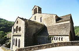
Abbey church | |
 Sylvanès | |
|
Location within Occitanie region  Sylvanès | |
| Coordinates: 43°50′03″N 2°57′33″E / 43.8342°N 2.9592°ECoordinates: 43°50′03″N 2°57′33″E / 43.8342°N 2.9592°E | |
| Country | France |
| Region | Occitanie |
| Department | Aveyron |
| Arrondissement | Millau |
| Canton | Camarès |
| Intercommunality | Rougier de Camarès |
| Government | |
| • Mayor (2008–2014) | Michel Wolkowitsky |
| Area1 | 16.96 km2 (6.55 sq mi) |
| Population (2008)2 | 93 |
| • Density | 5.5/km2 (14/sq mi) |
| Time zone | CET (UTC+1) |
| • Summer (DST) | CEST (UTC+2) |
| INSEE/Postal code | 12274 / 12360 |
| Elevation |
399–780 m (1,309–2,559 ft) (avg. 432 m or 1,417 ft) |
|
1 French Land Register data, which excludes lakes, ponds, glaciers > 1 km² (0.386 sq mi or 247 acres) and river estuaries. 2 Population without double counting: residents of multiple communes (e.g., students and military personnel) only counted once. | |
Sylvanès is a commune in the Aveyron department in southern France.
Geography
The Dourdou de Camarès forms part of the commune's southern border.
Population
| Historical population | ||
|---|---|---|
| Year | Pop. | ±% |
| 1793 | 439 | — |
| 1800 | 385 | −12.3% |
| 1836 | 404 | +4.9% |
| 1841 | 415 | +2.7% |
| 1846 | 407 | −1.9% |
| 1851 | 420 | +3.2% |
| 1856 | 407 | −3.1% |
| 1861 | 429 | +5.4% |
| 1866 | 429 | +0.0% |
| 1872 | 445 | +3.7% |
| 1876 | 503 | +13.0% |
| 1881 | 405 | −19.5% |
| 1886 | 382 | −5.7% |
| 1891 | 377 | −1.3% |
| 1896 | 407 | +8.0% |
| 1901 | 409 | +0.5% |
| 1906 | 408 | −0.2% |
| 1911 | 406 | −0.5% |
| 1921 | 329 | −19.0% |
| 1926 | 310 | −5.8% |
| 1931 | 288 | −7.1% |
| 1936 | 273 | −5.2% |
| 1946 | 215 | −21.2% |
| 1954 | 205 | −4.7% |
| 1962 | 159 | −22.4% |
| 1968 | 144 | −9.4% |
| 1975 | 109 | −24.3% |
| 1982 | 117 | +7.3% |
| 1990 | 108 | −7.7% |
| 1999 | 117 | +8.3% |
| 2008 | 93 | −20.5% |
See also
References
External links
| Wikimedia Commons has media related to Sylvanès. |
This article is issued from Wikipedia - version of the 3/15/2016. The text is available under the Creative Commons Attribution/Share Alike but additional terms may apply for the media files.