Camarès
| Camarès | ||
|---|---|---|
|
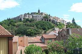
A general view of Camarès | ||
| ||
 Camarès | ||
|
Location within Occitanie region  Camarès | ||
| Coordinates: 43°49′24″N 2°52′49″E / 43.8233°N 2.8803°ECoordinates: 43°49′24″N 2°52′49″E / 43.8233°N 2.8803°E | ||
| Country | France | |
| Region | Occitanie | |
| Department | Aveyron | |
| Arrondissement | Millau | |
| Canton | Camarès | |
| Intercommunality | Rougier de Camarès | |
| Government | ||
| • Mayor (2008–2014) | Jacques Bernat | |
| Area1 | 41.86 km2 (16.16 sq mi) | |
| Population (2008)2 | 975 | |
| • Density | 23/km2 (60/sq mi) | |
| Time zone | CET (UTC+1) | |
| • Summer (DST) | CEST (UTC+2) | |
| INSEE/Postal code | 12044 / 12360 | |
| Elevation |
356–968 m (1,168–3,176 ft) (avg. 383 m or 1,257 ft) | |
|
1 French Land Register data, which excludes lakes, ponds, glaciers > 1 km² (0.386 sq mi or 247 acres) and river estuaries. 2 Population without double counting: residents of multiple communes (e.g., students and military personnel) only counted once. | ||
.svg.png)
Camarès is a commune in the Aveyron department in southern France.
Geography
Situated 23 kilometres south of Saint-Affrique and 80 kilometres from Béziers, the commune is traversed by the Dourdou de Camarès and sits at the foot of the Monts de Lacaune.
Its red soil, le rougier, is a schistose sandstone. It covers a rich substrate which was exploited for the first mines of copper and argentiferous lead during the Gallo-Roman era.
The commune includes a thermal basin with springs that are no longer in use today: Prugnes les eaux, Andabre, Le Cayla et Sylvanès (eau thermale).
Population
| Historical population | ||
|---|---|---|
| Year | Pop. | ±% |
| 1962 | 1,288 | — |
| 1968 | 1,253 | −2.7% |
| 1975 | 1,212 | −3.3% |
| 1982 | 1,258 | +3.8% |
| 1990 | 1,127 | −10.4% |
| 1999 | 1,008 | −10.6% |
| 2008 | 975 | −3.3% |
See also
References
| Wikimedia Commons has media related to Camarès. |
This article is issued from Wikipedia - version of the 11/4/2016. The text is available under the Creative Commons Attribution/Share Alike but additional terms may apply for the media files.