Onet-le-Château
| Onet-le-Château | |
|---|---|
|
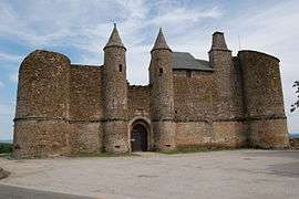
Chateau | |
 Onet-le-Château | |
|
Location within Occitanie region  Onet-le-Château | |
| Coordinates: 44°21′59″N 2°35′39″E / 44.3664°N 2.5942°ECoordinates: 44°21′59″N 2°35′39″E / 44.3664°N 2.5942°E | |
| Country | France |
| Region | Occitanie |
| Department | Aveyron |
| Arrondissement | Rodez |
| Canton | Rodez-Nord |
| Intercommunality | Grand Rodez |
| Government | |
| • Mayor (2008–2014) | Fabrice Geniez |
| Area1 | 40.2 km2 (15.5 sq mi) |
| Population (2008)2 | 10,643 |
| • Density | 260/km2 (690/sq mi) |
| Time zone | CET (UTC+1) |
| • Summer (DST) | CEST (UTC+2) |
| INSEE/Postal code | 12176 / 12850 |
| Elevation |
524–631 m (1,719–2,070 ft) (avg. 500 m or 1,600 ft) |
|
1 French Land Register data, which excludes lakes, ponds, glaciers > 1 km² (0.386 sq mi or 247 acres) and river estuaries. 2 Population without double counting: residents of multiple communes (e.g., students and military personnel) only counted once. | |
Onet-le-Château is a commune in the Aveyron department in southern France.
Population
| Historical population | ||
|---|---|---|
| Year | Pop. | ±% |
| 1793 | 103 | — |
| 1800 | 106 | +2.9% |
| 1806 | 1,397 | +1217.9% |
| 1821 | 1,408 | +0.8% |
| 1831 | 1,398 | −0.7% |
| 1836 | 1,265 | −9.5% |
| 1841 | 867 | −31.5% |
| 1846 | 941 | +8.5% |
| 1851 | 954 | +1.4% |
| 1856 | 988 | +3.6% |
| 1861 | 998 | +1.0% |
| 1866 | 916 | −8.2% |
| 1872 | 936 | +2.2% |
| 1876 | 1,057 | +12.9% |
| 1881 | 987 | −6.6% |
| 1886 | 1,030 | +4.4% |
| 1891 | 1,026 | −0.4% |
| 1896 | 944 | −8.0% |
| 1901 | 952 | +0.8% |
| 1906 | 953 | +0.1% |
| 1911 | 1,015 | +6.5% |
| 1921 | 984 | −3.1% |
| 1926 | 995 | +1.1% |
| 1931 | 1,002 | +0.7% |
| 1936 | 967 | −3.5% |
| 1946 | 1,060 | +9.6% |
| 1954 | 1,158 | +9.2% |
| 1962 | 1,515 | +30.8% |
| 1968 | 4,741 | +212.9% |
| 1975 | 6,391 | +34.8% |
| 1982 | 9,473 | +48.2% |
| 1990 | 9,705 | +2.4% |
| 1999 | 9,922 | +2.2% |
| 2008 | 10,643 | +7.3% |
See also
References
| Wikimedia Commons has media related to Onet-le-Château. |
This article is issued from Wikipedia - version of the 6/21/2015. The text is available under the Creative Commons Attribution/Share Alike but additional terms may apply for the media files.