Ayssènes
| Ayssènes | ||
|---|---|---|
|
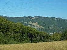
The hamlet of Le Pouget | ||
| ||
 Ayssènes | ||
|
Location within Occitanie region  Ayssènes | ||
| Coordinates: 44°04′13″N 2°46′49″E / 44.0703°N 2.7803°ECoordinates: 44°04′13″N 2°46′49″E / 44.0703°N 2.7803°E | ||
| Country | France | |
| Region | Occitanie | |
| Department | Aveyron | |
| Arrondissement | Millau | |
| Canton | Saint-Rome-de-Tarn | |
| Government | ||
| • Mayor (1995–2020) | Marie-Chantal Calmes-Bou | |
| Area1 | 23.14 km2 (8.93 sq mi) | |
| Population (2010)2 | 214 | |
| • Density | 9.2/km2 (24/sq mi) | |
| Time zone | CET (UTC+1) | |
| • Summer (DST) | CEST (UTC+2) | |
| INSEE/Postal code | 12017 / 12430 | |
| Elevation |
262–983 m (860–3,225 ft) (avg. 356 m or 1,168 ft) | |
|
1 French Land Register data, which excludes lakes, ponds, glaciers > 1 km² (0.386 sq mi or 247 acres) and river estuaries. 2 Population without double counting: residents of multiple communes (e.g., students and military personnel) only counted once. | ||

Ayssènes is a French commune in the Aveyron department in the Occitanie region of southern France.
The inhabitants of the commune are known as Ayssenols or Ayssenoles.[1]
Geography

Ayssènes is located some 25 km west of Millau and 7 km south-east of Alrance. Access to the commune is by the D510 road from Villefranche-de-Panat in the west which passes through the commune by a circuitous route to the village then continues south across the river to join the D200 on the opposite bank. Apart from the village there are the hamlets of:
- Ardennes
- Le Bastizou
- Cabière
- Calmels
- Le Caussanal
- La Caze
- La Clerguie
- Coupiaguet
- Le Crouzet
- Les Esclots
- Lescure
- Melet
- Le Pouget
- Rentières
- Saint-Rémy
- Vabrette
- Valergues
- Verdalle
- Vernet
The commune is mainly forest with large areas of farmland.[2]
The southern border of the commune is formed by the Tarn river which is dammed just south-west of the commune to form a long lake along the southern border. From the dam the Tarn continues south-west to eventually join the Garonne just west of Moissac. The Ruisseau de Vernobre rises in the north of the commune and flows south, gathering many tributaries, to join the Tarn. The Ruisseau de Coudols flows from the north-east, gathering some tributaries in the commune, and joins the Tarn at the same point as the Ruisseau de Vernobre.[2]
Neighbouring communes and villages[2]
 |
Alrance | Salles-Curan | Montjaux | |
| Villefranche-de-Panat | |
Viala-du-Tarn | ||
| ||||
| | ||||
| Le Truel | Les Costes-Gozon | Saint-Victor-et-Melvieu |
History
Middle Ages
The village was built on a ridge overlooking the Tarn and was a direct link between the Lévézou Plateau and Raspes du Tarn. There was once a fortress on the peak of Roc Saint-Jean. It belonged to the Count of Rodez who maintained a garrison in order to maintain his influence over the southern Rouergue. Prestigious guests stayed at this location including the King of France, Charles VII, on 13 May 1437 while returning from Languedoc where he had been to restore order.
Modern Era
The castle was the subject of much covetousness during the wars of religion. In October 1586 the army of the Duke of Joyeuse, Anne de Joyeuse - brother of King Henry III, tried to besiege it. The Captain of the garrison made a ploy and the duke's army retreated towards the plateau of Saint-Victor which was where the garrison captain attacked the camp at night - taking fifty horses and capturing several soldiers. The fortress became dangerous for the kingdom and was destroyed in 1629 by order of Cardinal Richelieu. Today nothing remains but the location has one of the most beautiful views in the region.
Contemporary era
The commune consisted of four parishes in the second half of the 19th century with a population of around 1500. Today there are no more than 213 year-round residents.
Heraldry
 |
Blazon: Party per pale, first Gules, a lion Or tongued and armed in Sable; second Azure, a tower Argent embattled of 4 pieces, ensigned with a Latin crosslet the same, port open, masoned in Sable, debruised by two swords Argent hilt and pommel Gules saltirewise; in base three fesses Argent wavy. |
Administration

List of Successive Mayors[3]
| From | To | Name | Party | Position |
|---|---|---|---|---|
| 1875 | 1888 | Galtier Calmeyrac | ||
| 1888 | 1889 | Basile Bonnefous | ||
| 1889 | 1892 | Félix Galtier | ||
| 1892 | 1904 | Paulin Brengues | ||
| 1904 | 1910 | Justin Fabre | ||
| 1910 | 1912 | Camille Bou | ||
| 1912 | 1914 | Edouard Cambefort | ||
| 1914 | 1919 | Benoît Costes | ||
| 1919 | 1953 | Edouard Cambefort | ||
| 1953 | 1995 | René Arles | ||
| 1995 | 2020 | Marie-Chantal Calmes-Bou |
(Not all data is known)
Demography
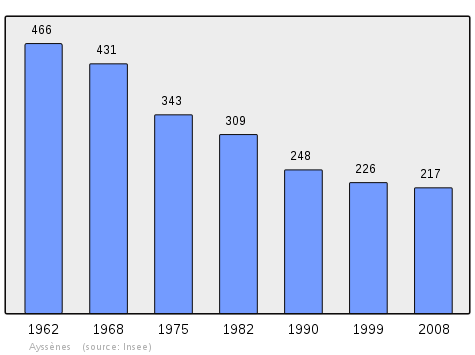
In 2010 the commune had 214 inhabitants. The evolution of the number of inhabitants is known from the population censuses conducted in the commune since 1793. From the 21st century, a census of communes with fewer than 10,000 inhabitants is held every five years, unlike larger communes that have a sample survey every year.[Note 1]
| 1793 | 1800 | 1806 | 1821 | 1831 | 1836 | 1841 | 1846 | 1851 |
|---|---|---|---|---|---|---|---|---|
| 591 | - | - | - | - | - | - | - | - |
| 1856 | 1861 | 1866 | 1872 | 1876 | 1881 | 1886 | 1891 | 1896 |
|---|---|---|---|---|---|---|---|---|
| - | - | - | - | 1,219 | 1,149 | 1,130 | 1,125 | 1,038 |
| 1901 | 1906 | 1911 | 1921 | 1926 | 1931 | 1936 | 1946 | 1954 |
|---|---|---|---|---|---|---|---|---|
| 1,014 | 956 | 963 | 828 | 770 | 739 | 740 | 663 | 568 |
| 1962 | 1968 | 1975 | 1982 | 1990 | 1999 | 2006 | 2010 | - |
|---|---|---|---|---|---|---|---|---|
| 466 | 431 | 343 | 309 | 248 | 226 | - | 214 | - |
Sources : Ldh/EHESS/Cassini until 1962, INSEE database from 1968 (population without double counting and municipal population from 2006)
Sites and monuments

- The Old Ayssènes Cemetery (graves from the early 19th century).
- The Roc Saint-Jean (The castle disappeared after Richelieu ordered its destruction)
- The Roc du Cavalier
- The Church of the Nativity of Mary (Ayssènes) (19th century)
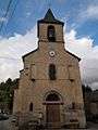
- The Church of Saint-Amans (at Coupiaguet) (19th century)
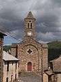
- The Church of Saint Rémy (at Saint-Rémy) (19th century)
- The Church of Saint-Blaise or of the Purification of Notre-Dame (at Vabrette) (19th century). The church contains two items that are registered as historical objects:
- The House of Chestnuts
-

Church of St-Rémy.
-

Church of Saint-Amans.
-
Church of Saint-Blaise.
-
Church of the Nativity of Mary.
Notable people linked to the commune
- Antoine Salvanh (1479-1555). Architect specialising in religious buildings, builder of the bell tower on Rodez Cathedral between 1513 and 1526.
- Guillaume Molinier-Lamothe (1736-1794). Refractory priest jailed in 1793 in Rodez then deported to the Fort du Hâ at Bordeaux the following year where he died.
- Georges Connes (1890-1974). Senior lecturer at the University of Dijon, Doctor of Literature, Dean of the University of Dijon in 1946 and 1947, resistance fighter in 1943, Mayor of Dijon after the liberation of the city in September 1944.
- Pierre-Damien Hèbles (1864-1954). Priest for Ayssènes from 1903 to 1944, member of the literary society of Aveyron, historian for the Raspes du Tarn region. He wrote three manuscripts on local history after 40 years of research in the departmental archives and deeds.
- Gaston Boulouis (1908-1991) Priest, Professor of Literature at the Seminary Minor of Saint Pierre and at the Sainte Marie de Rodez Institution. Canon, historian and occitan scholar at the end of his life. He published several historical books on the region as well as an autobiography and a collection of Occitan proverbs.
- Alain Marc (born in 1957). Politician, Municipal councillor for Ayssènes from 2001 to 2004, he has been MP for Aveyron since 2007.
See also
Bibliography
- Christian-Pierre Bedel, preface by Alain Marc, Sant-Roma, Aissenas, Broquièrs, Brossa, Las Còstas, L'Estrada, Sant-Victor, Lo Truèlh / Christian-Pierre Bedel e los estatjants del canton de Sant-Roma, Rodez, Departmental Mission for culture, 1995, Al canton collection, 239 pages, ill., cov. ill., 28 cm, ISBN 2-907279-20-3, ISSN 1151-8375, BnF 366885722 (Occitan)/(French)
External links
- Canton of Saint-Rome de Tarn website (French)
- Ayssènes on Lion1906
- Ayssènes on Google Maps
- Ayssènes on Géoportail, National Geographic Institute (IGN) website (French)
- Ayßene on the 1750 Cassini Map
- Ayssènes on the INSEE website (French)
- INSEE (French)
Notes and references
Notes
- ↑ At the beginning of the 21st century, the methods of identification have been modified by Law No. 2002-276 of 27 February 2002, the so-called "law of local democracy" and in particular Title V "census operations" allows, after a transitional period running from 2004 to 2008, the annual publication of the legal population of the different French administrative districts. For communes with a population greater than 10,000 inhabitants, a sample survey is conducted annually, the entire territory of these communes is taken into account at the end of the period of five years. The first "legal population" after 1999 under this new law came into force on 1 January 2009 and was based on the census of 2006.
References
- ↑ Inhabitants of Aveyron (French)
- 1 2 3 Google Maps
- ↑ List of Mayors of France (French)
- ↑ Ministry of Culture, Palissy PM12000911 Chasuble
(French)

- ↑ Ministry of Culture, Palissy PM12000910 Chasuble
(French)
| Wikimedia Commons has media related to Ayssènes. |