Sainte-Radegonde, Aveyron
| Sainte-Radegonde | ||
|---|---|---|
|
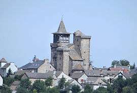
The village of Sainte-Radegonde, with the fortified church | ||
| ||
 Sainte-Radegonde | ||
|
Location within Occitanie region  Sainte-Radegonde | ||
| Coordinates: 44°20′12″N 2°37′38″E / 44.336751°N 2.627141°ECoordinates: 44°20′12″N 2°37′38″E / 44.336751°N 2.627141°E | ||
| Country | France | |
| Region | Occitanie | |
| Department | Aveyron | |
| Arrondissement | Rodez | |
| Canton | Rodez-Est | |
| Intercommunality | Grand Rodez | |
| Government | ||
| • Mayor (2008–2014) | Michel Delpal | |
| Area1 | 30.48 km2 (11.77 sq mi) | |
| Population (2008)2 | 1,587 | |
| • Density | 52/km2 (130/sq mi) | |
| Time zone | CET (UTC+1) | |
| • Summer (DST) | CEST (UTC+2) | |
| INSEE/Postal code | 12241 / 12850 | |
| Elevation |
526–791 m (1,726–2,595 ft) (avg. 535 m or 1,755 ft) | |
|
1 French Land Register data, which excludes lakes, ponds, glaciers > 1 km² (0.386 sq mi or 247 acres) and river estuaries. 2 Population without double counting: residents of multiple communes (e.g., students and military personnel) only counted once. | ||

Sainte-Radegonde is a commune in the Aveyron department in southern France.
Population
| Historical population | ||
|---|---|---|
| Year | Pop. | ±% |
| 1962 | 489 | — |
| 1968 | 452 | −7.6% |
| 1975 | 563 | +24.6% |
| 1982 | 1,027 | +82.4% |
| 1990 | 1,226 | +19.4% |
| 1999 | 1,355 | +10.5% |
| 2008 | 1,587 | +17.1% |
See also
References
| Wikimedia Commons has media related to Sainte-Radegonde, Aveyron. |
This article is issued from Wikipedia - version of the 3/9/2015. The text is available under the Creative Commons Attribution/Share Alike but additional terms may apply for the media files.