Salles-la-Source
| Salles-la-Source | |
|---|---|
|
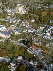
An aerial view of Salles-la-Source | |
 Salles-la-Source | |
|
Location within Occitanie region  Salles-la-Source | |
| Coordinates: 44°26′10″N 2°30′51″E / 44.4361°N 2.5142°ECoordinates: 44°26′10″N 2°30′51″E / 44.4361°N 2.5142°E | |
| Country | France |
| Region | Occitanie |
| Department | Aveyron |
| Arrondissement | Rodez |
| Canton | Marcillac-Vallon |
| Intercommunality | Causse et Vallon de Marcillac |
| Government | |
| • Mayor (2008–2014) | Robert Caule |
| Area1 | 78.03 km2 (30.13 sq mi) |
| Population (2008)2 | 2,028 |
| • Density | 26/km2 (67/sq mi) |
| Time zone | CET (UTC+1) |
| • Summer (DST) | CEST (UTC+2) |
| INSEE/Postal code | 12254 / 12330 |
| Elevation | 290–613 m (951–2,011 ft) |
|
1 French Land Register data, which excludes lakes, ponds, glaciers > 1 km² (0.386 sq mi or 247 acres) and river estuaries. 2 Population without double counting: residents of multiple communes (e.g., students and military personnel) only counted once. | |
Salles-la-Source is a commune in the Aveyron department in southern France.
The Rodez-Marcillac Airport is located in Salles-la-Source.
See also
References
| Wikimedia Commons has media related to Salles-la-Source. |
This article is issued from Wikipedia - version of the 3/9/2015. The text is available under the Creative Commons Attribution/Share Alike but additional terms may apply for the media files.