Arques, Aveyron
| Arques | |
|---|---|
|
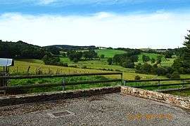
A general view of Arques | |
 Arques | |
|
Location within Occitanie region  Arques | |
| Coordinates: 44°19′05″N 2°48′05″E / 44.3181°N 2.8014°ECoordinates: 44°19′05″N 2°48′05″E / 44.3181°N 2.8014°E | |
| Country | France |
| Region | Occitanie |
| Department | Aveyron |
| Arrondissement | Rodez |
| Canton | Pont-de-Salars |
| Intercommunality | Pays de Salars |
| Government | |
| • Mayor (2008–2020) | Bernard Andrieu |
| Area1 | 11.29 km2 (4.36 sq mi) |
| Population (2009)2 | 118 |
| • Density | 10/km2 (27/sq mi) |
| Time zone | CET (UTC+1) |
| • Summer (DST) | CEST (UTC+2) |
| INSEE/Postal code | 12010 / 12290 |
| Elevation |
714–947 m (2,343–3,107 ft) (avg. 800 m or 2,600 ft) |
|
1 French Land Register data, which excludes lakes, ponds, glaciers > 1 km² (0.386 sq mi or 247 acres) and river estuaries. 2 Population without double counting: residents of multiple communes (e.g., students and military personnel) only counted once. | |
Arques is a French commune in the Aveyron department in the Occitanie region of southern France.
The inhabitants of the commune are known as Arcasois or Arcasoises[1]
Geography
Arques is located some 16 km east by south-east of Rodez and 6 km south of Laissac. Access to the commune is by road D29 from Agen-d'Aveyron in the north-west passing through the commune and the village and continuing south-east to Ségur. Apart from the village there are the hamlets of Le Mazet in the eastern arm of the commune and Moulin Fabre and Recoules south of the village. Except for two forests in the north the commune is entirely farmland.[2]
The Ruisseau des Gardies rises in the north of the commune and flows south through the village joining the Viaur south of the village. The Ruisseau de Clauverhes rises in the north-east of the commune and flows south-east to join the Viaur south of the village. The Viaur river flows from the south-west through the southern part of the commune and forming part of the southern border before continuing west to the Barrage of Pont-de-Salars then continuing west to eventually join the Aveyron river at Saint-Martin-Laguépie.[2]
Neighbouring communes and villages[2]
 |
Laissac | Sévérac-l'Église | | |
| Le Vibal | |
Lavernhe | ||
| ||||
| | ||||
| Pont-de-Salars | Prades-Salars | Ségur |
Toponymy
The word Arques derives from the Latin arx meaning "fortress".
History
The lordship of Arques extended over the Palanges mountains and included the current commune of the same name plus two enclaves currently in the communes of Segur and Vézins-de-Lévézou. Arques is mentioned in a donation to the Abbey of Conques in 1079. It was later attached to the Abbey of La Chaise-Dieu. It was a dependency of the Lordship of Montrozier, under the Count of Rodez, then of the king.
Administration
List of Successive Mayors[3]
| From | To | Name | Party | Position |
|---|---|---|---|---|
| 1792 | 1793 | Jean Clusel | ||
| 1793 | 1796 | Laurens Carrie | ||
| 1796 | 1800 | François Routaboul | ||
| 1800 | 1805 | Jean-Louis Fabre | ||
| 1805 | 1836 | Jean Clusel | ||
| 1836 | 1837 | Firmin Carrie | ||
| 1837 | 1847 | Jean Victor Clusel | ||
| 1847 | 1848 | Pierre François Gineste | ||
| 1848 | 1870 | Basile Gineste | ||
| 1870 | 1876 | Louis Poujade | ||
| 1876 | 1892 | Henri Marican | ||
| 1892 | 1900 | Casimir Fabre | ||
| 1900 | 1904 | Henri Marican | ||
| 1904 | 1916 | Basile Gineste | ||
| 1916 | 1919 | Joseph Amans | ||
| 1919 | 1935 | Marty Bru |
- Mayors from 1935
| From | To | Name | Party | Position |
|---|---|---|---|---|
| 1935 | 1965 | Joseph Amans | ||
| 1965 | 1976 | Albert Gineste | ||
| 1976 | 1977 | Guy Gineste | ||
| 1977 | 2020 | Bernard Andrieu | UMP |
(Not all data is known)
Demography
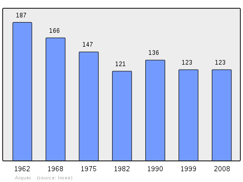
In 2009 the commune had 118 inhabitants. The evolution of the number of inhabitants is known from the population censuses conducted in the commune since 1793. From the 21st century, a census of communes with fewer than 10,000 inhabitants is held every five years, unlike larger towns that have a sample survey every year.[Note 1]
| 1793 | 1800 | 1806 | 1821 | 1831 | 1836 | 1841 | 1846 | 1851 |
|---|---|---|---|---|---|---|---|---|
| 358 | 381 | 384 | 400 | 266 | 301 | 440 | 416 | 377 |
| 1856 | 1861 | 1866 | 1872 | 1876 | 1881 | 1886 | 1891 | 1896 |
|---|---|---|---|---|---|---|---|---|
| 365 | 333 | 292 | 308 | 310 | 301 | 286 | 272 | 240 |
| 1901 | 1906 | 1911 | 1921 | 1926 | 1931 | 1936 | 1946 | 1954 |
|---|---|---|---|---|---|---|---|---|
| 253 | 248 | 219 | 215 | 206 | 215 | 208 | 205 | 187 |
| 1962 | 1968 | 1975 | 1982 | 1990 | 1999 | 2006 | 2009 | - |
|---|---|---|---|---|---|---|---|---|
| 187 | 166 | 147 | 121 | 136 | 123 | 130 | 118 | - |
Sources : Ldh/EHESS/Cassini until 1962, INSEE database from 1968 (population without double counting and municipal population from 2006)
Distribution of Age Groups
The table below compares the gender and age of the population with that of the department of Aveyron in the year 2009. Unlike national and departmental allocations, the male population of the town is greater than the female population (52.5% against 48.4% nationally and 48.2% at the departmental level).
Percentage Distribution of Age Groups in Arques and Aveyron Department in 2009
| Arques | Arques | Aveyron | Aveyron | |
|---|---|---|---|---|
| Age Range | Men | Women | Men | Women |
| 0 to 14 Years | 11.3 | 14.3 | 16.7 | 15.1 |
| 15 to 29 Years | 19.4 | 10.7 | 15.1 | 13.4 |
| 30 to 44 Years | 17.7 | 17.9 | 18.9 | 17.8 |
| 45 to 59 Years | 30.6 | 28.6 | 21.6 | 20.3 |
| 60 to 74 Years | 9.7 | 10.7 | 16.9 | 17.5 |
| 75 to 89 Years | 11.3 | 17.9 | 10.2 | 14.2 |
| 90 Years+ | 0.0 | 0.0 | 0.6 | 1.7 |
Sources:
- Evolution and Structure of the population of the Commune in 2009, INSEE.
- Evolution and Structure of the population of the Department in 2009, INSEE.
Sites and Monuments
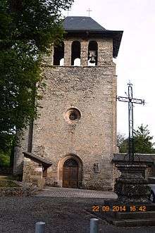
- A Parish Church from the 16th century, a Bell-gable, and an altarpiece from the 17th century - gilded in the 18th century. A Bronze Bell (1755)
 is registered as a historical monument.[4]
 - The Rives Viaur, a hilly site at the end of Lake Pont-de-Salars.
See also
Bibliography
- Christian-Pierre Bedel (preface, Alain Pichon), Lo Pònt : Agenh, Arcas, Canet, Flavinh, Pradas, Tremolhas, Lo Vibal / Christian-Pierre Bedel e los estatjants del canton del Pònt, Rodez, Departmental Mission for culture, coll. "Al Canton", 1995, ill., cover ill.; 28 cm, 239 p. (ISBN 978-2-907279-20-8, ISSN 1151-8375, Notice BnF No. FRBNF36688567g) (Occitan/French)
Notes and references
Notes
- ↑ At the beginning of the 21st century, the methods of identification have been modified by Law No. 2002-276 of 27 February 2002, the so-called "law of local democracy" and in particular Title V "census operations" allows, after a transitional period running from 2004 to 2008, the annual publication of the legal population of the different French administrative districts. For communes with a population greater than 10,000 inhabitants, a sample survey is conducted annually, the entire territory of these communes is taken into account at the end of the period of five years. The first "legal population" after 1999 under this new law came into force on 1 January 2009 and was based on the census of 2006.
References
- ↑ Inhabitants of Aveyron (French)
- 1 2 3 Google Maps
- ↑ List of Mayors of France (French)
- ↑ Ministry of Culture, Palissy PM12000001 Bronze Bell (French)
External links
| Wikimedia Commons has media related to Arques (Aveyron). |
- Arques on Lion1906
- Arques on Google Maps
- Arques on Géoportail, National Geographic Institute (IGN) website (French)
- Argues on the 1750 Cassini Map
- Arques on the INSEE website (French)
- INSEE (French)