Saratoga Springs, California
| Saratoga Springs | |
|---|---|
| Unincorporated community | |
 | |
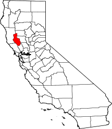
 Saratoga Springs  Saratoga Springs Location in California | |
| Coordinates: 39°10′31″N 122°58′51″W / 39.17528°N 122.98083°WCoordinates: 39°10′31″N 122°58′51″W / 39.17528°N 122.98083°W | |
| Country | United States |
| State | California |
| County | Lake County |
| Opened | 1873 |
| Area | |
| • Total | 260 acres (110 ha) |
| Elevation[1] | 1,427 ft (435 m) |
| Website | http://www.saratogasprings.com/ |
Saratoga Springs (formerly, Bachelor[2] and Pierson Springs[2]) is an unincorporated community in Lake County, California.[1] It is located 4 miles (6.4 km) west of Upper Lake,[2] at an elevation of 1427 feet (435 m).[1]
The town was originally located 3.5 miles (5.6 km) north of its present location.[2] The Bachelor post office opened in 1882, moved to this site in 1883, closed in 1919, reopened in 1920, and closed for good in 1940.[2]
The town has a resort, begun in the 1870s, which offered multiple cold mineral springs for bathing and a bottling plant for drinking, and by 1910 could accommodate 250 guests.[2] It included a stagecoach stop, dance hall and restaurant. Previously the springs had been frequented by the Pomo people. The resort re-opened in 1991 after decades of disuse and continues in operation using some of the original buildings.