Lakeport, California
| Lakeport, California | |
|---|---|
| City | |
|
Main Street | |
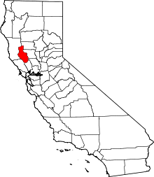
 Location within Lake County and California | |
| Coordinates: 39°02′35″N 122°54′57″W / 39.04306°N 122.91583°WCoordinates: 39°02′35″N 122°54′57″W / 39.04306°N 122.91583°W | |
| Country |
|
| State |
|
| County | Lake |
| Incorporated | April 30, 1888[1] |
| Area[2] | |
| • Total | 3.198 sq mi (8.284 km2) |
| • Land | 3.058 sq mi (7.920 km2) |
| • Water | 0.140 sq mi (0.364 km2) 4.39% |
| Elevation[3] | 1,355 ft (413 m) |
| Population (2010) | |
| • Total | 4,753 |
| • Density | 1,500/sq mi (570/km2) |
| Time zone | Pacific (PST) (UTC-8) |
| • Summer (DST) | PDT (UTC-7) |
| ZIP code | 95453 [4] |
| Area code | 707 |
| FIPS code | 06-39710 |
| GNIS feature ID | 0277536 |
| Website |
cityoflakeport |

Lakeport is an incorporated city and county seat of Lake County, California.[3] Lakeport is located on the west shore of Clear Lake,[5] at an elevation of 1355 feet (413 m).[3] The population was 4,753 at the 2010 census, down from 4,820 at the time of the 2000 census.
History
The city was formerly named Forbestown, Rocky Point, Stony Point, and Tuckertown.
Lakeport was first settled by Native Americans several thousand years ago. At the coming of the settlers, the Kabe-napos, a subtribe of the Pomo people, lived here within their main village. The village name was Kaci-Badon, after the water lily plant Kaci and badon which was the native name for island.[6]
The first business in Lakeport was established in 1855. Goods were traded to the natives for their wares and baskets. The business was run by a man named Johnson, but he did not have a store location. The first shop built in the Lakeport area was constructed by Dr. Boynton.
It was William Forbes and James Parrish, however, who created the first shop in the main Lakeport area. Parish was a blacksmith and Forbes was a wagon maker. Forbes was also a pioneer undertaker. It was this investment as well as the land grant Forbes bestowed upon the county, which earned Lakeport its first name: Forbestown.
William Forbes came to the area in 1858. He purchased 160 acres (0.6 km2) on which to build his home and farm. When the county was investigating land to put the local county seat, Forbes offered 40 acres (160,000 m2) of his property on which they could build the county office. The electorate thanked Forbes for his generosity by naming the town after him. Although the town no longer bears his name, other landmarks still retain their name association to the late William Forbes.
On June 14, 1861, Forbestown was officially changed to Lakeport. Some locations still bear the Forbes name, however, such as Forbes Creek and Forbes Street.
In 1850, Captain Nathaniel Lyon led an attack in the Bloody Island Massacre. Lyon would later die fighting for the Union in the Civil War.[7]
The first post office, called Big Valley, opened at the site in 1858, and changed its name to Lakeport in 1861.[5]
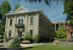
The first Lakeport courthouse was built from wood in 1861. The building burnt under suspicious circumstances in 1867.
In 1864, the Cache Creek Dam was built. Four years later, the locals tore the dam down and destroyed the mills it helped operate, after waters diverted by the dam flood most of Lower Lake and Anderson Ranch.[8]
In 1872, a spotting of the legendary "Monster of Blue Lakes" or "Devil Fish" caused Indians from all around to gather at Temescal to await an expected calamity.
In 1882, Black Bart robbed the stage traveling between Lakeport and Cloverdale. During this time period, over 450 Chinese immigrants were employed to work the area's quicksilver mines.
In 1883, William "Digger" Jones was hanged at Lakeport jail. He was the only white man ever legally hanged by the county.
In 1888, Lakeport was incorporated. For nearly a century, it was the only incorporated city in Lake County.
In 1892, Lakeport got its first telephone.
Geography
Lakeport is located at 39°02′35″N 122°54′57″W / 39.04306°N 122.91583°W.[3] According to the United States Census Bureau, the city has a total area of 3.2 square miles (8.3 km2), of which, 3.1 square miles (8.0 km2) of it is land and 0.1 square miles (0.26 km2) of it (4.39%) is water.
The Lakeport area is located on a sediment-filled valley adjacent to Clear Lake. Exposed materials within the area are limited to serpentinite and quaternary sediments. These sediments are poorly consolidated to unconsolidated mixtures of sand, silt, clay, and gravel derived from older rock in the adjacent mountains. Because of the low strength of the quaternary sediments, they are subject to rapid erosion and shallow slumping.
The greatest number of faults in the County occur in the Cobb Mountain area and Hopland Grade area running southeasterly to the southern County line. The southeastern portion of the County also appears to have considerable earthquake faults. There are also active faults within the vicinity of the City of Lakeport, including the San Andreas Fault which is 30 miles (48 km) to the west, and the Healdsburg Fault which is 15 miles (24 km) to the west. These faults have been responsible for moderate to major earthquakes in the past. The maximum creditable earthquake magnitudes are 8.25 for the San Andreas fault and 6.75 for the Healdsburg fault.[9]
There is a potentially active rupture zone (defined as a fault that has been active during quaternary time - the last 2,000,000 years) existing immediately east of the City limits running parallel and adjacent to the shoreline of Clear Lake. Within the past 200 years, no major potentially damaging earthquakes have occurred along any faults within Lake County, including the Big Valley fault adjacent to the eastern City boundaries. Geologically, recent faulting is indicated, however, by the apparent displacement of quaternary earth materials along the Big Valley fault.
The largest earthquake to affect the City was the 1906 San Francisco earthquake which had a magnitude of 8.3. Although shaking was severe, overall damage in Lakeport was comparatively minor and generally limited to the fall of decorative masonry and chimneys.
The city relies on wells for the majority of its potable supply. In periods of high rainfall flooding from Clear Lake, Scotts Creek and Forbes Creek, have caused historic property damage.
Climate
Lakeport, as well as all of the Clear Lake area, has hot, mostly dry summers and cool, wet winters. The average January temperatures are a maximum of 53.4 °F (11.9 °C) and a minimum of 31.5 °F (−0.3 °C). The average July temperatures are a maximum of 94.4 °F (34.7 °C) and a minimum of 53.0 °F (11.7 °C). There are an average of 77.5 days with highs of 90 °F (32 °C) or higher and an average of 75.5 days with lows of 32 °F (0 °C). The record high temperature was 112 °F (44 °C) on August 10, 1971, and September 13, 1972. The record low temperature was 9 °F (−13 °C) on December 9, 1972. Its climate can be classified as hot-summer Mediterranean climate according to the Köppen climate classification system.
Average annual precipitation is 28.36 inches (72.0 cm). There are an average of 66 days with measurable precipitation. The wettest year was 1973 with 44.50 inches (113.0 cm) and the driest year was 2013. The most precipitation in one month was 19.62 inches (49.8 cm) in February 1986. The most precipitation is 24 hours was 5.43 inches (13.8 cm) on December 10, 1937.
Snow is relatively rare in Lakeport, but common in the surrounding mountains. Average annual snowfall is 1.0 inch (2.5 cm). The most snow in one month was 15.0 inches (38 cm) in January 1937.[10]
| Climate data for Lakeport | |||||||||||||
|---|---|---|---|---|---|---|---|---|---|---|---|---|---|
| Month | Jan | Feb | Mar | Apr | May | Jun | Jul | Aug | Sep | Oct | Nov | Dec | Year |
| Record high °C (°F) | 72 (22) |
79 (26) |
82 (28) |
91 (33) |
99 (37) |
106 (41) |
109 (43) |
106 (41) |
106 (41) |
95 (35) |
90 (32) |
77 (25) |
109 (43) |
| Average high °C (°F) | 52 (11) |
55 (13) |
61 (16) |
68 (20) |
77 (25) |
82 (28) |
93 (34) |
91 (33) |
88 (31) |
75 (24) |
61 (16) |
54 (12) |
71.4 (21.9) |
| Daily mean °C (°F) | 41 (5) |
45 (7) |
46 (8) |
52 (11) |
59 (15) |
64 (18) |
72 (22) |
70 (21) |
66 (19) |
57 (14) |
48 (9) |
43 (6) |
55.3 (12.9) |
| Average low °C (°F) | 30 (−1) |
34 (1) |
34 (1) |
37 (3) |
43 (6) |
46 (8) |
52 (11) |
50 (10) |
46 (8) |
41 (5) |
36 (2) |
34 (1) |
40.3 (4.6) |
| Record low °C (°F) | 14 (−10) |
21 (−6) |
25 (−4) |
28 (−2) |
30 (−1) |
30 (−1) |
34 (1) |
36 (2) |
— | 27 (−3) |
23 (−5) |
18 (−8) |
14 (−10) |
| Average precipitation mm (inches) | 5.91 (150) |
5.12 (130) |
3.54 (90) |
1.57 (40) |
0.79 (20) |
0 (0) |
0 (0) |
0 (0) |
0 (0) |
1.18 (30) |
2.76 (70) |
5.12 (130) |
25.99 (660) |
| Source: [11] | |||||||||||||
Demographics
| Historical population | |||
|---|---|---|---|
| Census | Pop. | %± | |
| 1880 | 562 | — | |
| 1890 | 991 | 76.3% | |
| 1900 | 726 | −26.7% | |
| 1910 | 870 | 19.8% | |
| 1920 | 1,024 | 17.7% | |
| 1930 | 1,318 | 28.7% | |
| 1940 | 1,490 | 13.1% | |
| 1950 | 1,983 | 33.1% | |
| 1960 | 2,303 | 16.1% | |
| 1970 | 3,005 | 30.5% | |
| 1980 | 3,675 | 22.3% | |
| 1990 | 4,390 | 19.5% | |
| 2000 | 4,820 | 9.8% | |
| 2010 | 4,753 | −1.4% | |
| Est. 2015 | 4,807 | [12] | 1.1% |
2010
The 2010 United States Census[14] reported that Lakeport had a population of 4,753. The population density was 1,486.0 people per square mile (573.8/km²). The racial makeup of Lakeport was 3,932 (82.7%) White, 46 (1.0%) African American, 147 (3.1%) Native American, 99 (2.1%) Asian, 5 (0.1%) Pacific Islander, 337 (7.1%) from other races, and 187 (3.9%) from two or more races. Hispanic or Latino of any race were 799 persons (16.8%).
The Census reported that 4,616 people (97.1% of the population) lived in households, 11 (0.2%) lived in non-institutionalized group quarters, and 126 (2.7%) were institutionalized.
There were 2,002 households, out of which 563 (28.1%) had children under the age of 18 living in them, 803 (40.1%) were opposite-sex married couples living together, 260 (13.0%) had a female householder with no husband present, 110 (5.5%) had a male householder with no wife present. There were 177 (8.8%) unmarried opposite-sex partnerships, and 16 (0.8%) same-sex married couples or partnerships. 665 households (33.2%) were made up of individuals and 328 (16.4%) had someone living alone who was 65 years of age or older. The average household size was 2.31. There were 1,173 families (58.6% of all households); the average family size was 2.93.
The population was spread out with 1,031 people (21.7%) under the age of 18, 352 people (7.4%) aged 18 to 24, 1,033 people (21.7%) aged 25 to 44, 1,384 people (29.1%) aged 45 to 64, and 953 people (20.1%) who were 65 years of age or older. The median age was 44.2 years. For every 100 females there were 90.8 males. For every 100 females age 18 and over, there were 86.8 males.
There were 2,395 housing units at an average density of 748.8 per square mile (289.1/km²), of which 1,198 (59.8%) were owner-occupied, and 804 (40.2%) were occupied by renters. The homeowner vacancy rate was 5.1%; the rental vacancy rate was 8.4%. 2,661 people (56.0% of the population) lived in owner-occupied housing units and 1,955 people (41.1%) lived in rental housing units.
2000
As of the census[15] of 2000, there were 4,820 people, 1,967 households, and 1,233 families residing in the city. The population density was 1,799.8 people per square mile (694.4/km²). There were 2,394 housing units at an average density of 893.9 per square mile (344.9/km²). The racial makeup of the city was 88.7% White, 0.8% African American, 2.0% Native American, 1.5% Asian, 0.2% Pacific Islander, 3.5% from other races, and 3.4% from two or more races. Hispanic or Latino of any race were 11.5% of the population.
There were 1,967 households out of which 29.7% had children under the age of 18 living with them, 44.7% were married couples living together, 12.6% had a female householder with no husband present, and 37.3% were non-families. 31.0% of all households were made up of individuals and 16.2% had someone living alone who was 65 years of age or older. The average household size was 2.36 and the average family size was 2.93.
In the city the population was spread out with 24.5% under the age of 18, 6.9% from 18 to 24, 24.7% from 25 to 44, 22.8% from 45 to 64, and 21.0% who were 65 years of age or older. The median age was 41 years. For every 100 females there were 86.9 males. For every 100 females age 18 and over, there were 84.7 males.
The median income for a household in the city was $32,226, and the median income for a family was $37,900. Males had a median income of $36,719 versus $25,089 for females. The per capita income for the city was $17,215. About 13.5% of families and 15.7% of the population were below the poverty line, including 20.9% of those under age 18 and 5.6% of those age 65 or over.
Given the fact that the Lakeport area has an economy that is based somewhat on agricultural activities occurring in the Big Valley and Scotts Valley area which involve the growing and harvesting of food and nut crops as well as the increasing wine industry, there are a significant number of transient and seasonal farm workers. The need for housing, health care services, child care, and other services is clearly evident in this segment of the population. Insufficient data is available that quantifies the total number of seasonal or transient farm laborers that are living or working in the Lakeport area.
Government
In the California State Legislature, Lakeport is in the 2nd Senate District, represented by Democrat Mike McGuire, and in the 4th Assembly District, represented by Democrat Cecilia Aguiar-Curry.[16]
Federally, Lakeport is in California's 5th congressional district, represented by Democrat Mike Thompson.[17]
References
- ↑ "California Cities by Incorporation Date" (Word). California Association of Local Agency Formation Commissions. Retrieved August 25, 2014.
- ↑ "2010 Census U.S. Gazetteer Files – Places – California". United States Census Bureau.
- 1 2 3 4 U.S. Geological Survey Geographic Names Information System: Lakeport, California
- ↑ "ZIP Code(tm) Lookup". United States Postal Service. Retrieved December 6, 2014.
- 1 2 Durham, David L. (1998). California's Geographic Names: A Gazetteer of Historic and Modern Names of the State. Clovis, Calif.: Word Dancer Press. p. 90. ISBN 1-884995-14-4.
- ↑ "History of Clear Lake, Mt. Konocti and the Lake County Cattle Industry" by Henry K. Mauldin 1960
- ↑ "History of Lake County 1881" by Henry Hudson 1881.
- ↑ "A Description of Lake County California" published by Authority of the Board of Supervisors, 1888
- ↑ City of Lakeport General Plan to 2020, Earth Metrics Inc, 1989
- ↑ http://www.wrcc.dri.edu/cgi-bin/cliMAIN.pl?ca4701
- ↑ "Lakeport, California". Retrieved 23 October 2014.
- ↑ "Annual Estimates of the Resident Population for Incorporated Places: April 1, 2010 to July 1, 2015". Retrieved July 2, 2016.
- ↑ "Census of Population and Housing". Census.gov. Retrieved June 4, 2015.
- ↑ "2010 Census Interactive Population Search: CA - Lakeport city". U.S. Census Bureau. Retrieved July 12, 2014.
- ↑ "American FactFinder". United States Census Bureau. Retrieved 2008-01-31.
- ↑ "Statewide Database". UC Regents. Retrieved December 4, 2014.
- ↑ "California's 5th Congressional District - Representatives & District Map". Civic Impulse, LLC. Retrieved March 3, 2013.
External links
| Wikimedia Commons has media related to Lakeport, California. |