Slayton, Minnesota
| Slayton, Minnesota | |
|---|---|
| City | |
|
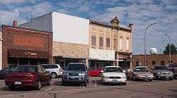
Downtown Slayton | |
| Motto: "A Community Of Ambitions In Action" | |
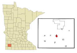 Location of Slayton within Murray County and state of Minnesota | |
| Coordinates: 43°59′18″N 95°45′21″W / 43.98833°N 95.75583°W | |
| Country | United States |
| State | Minnesota |
| County | Murray |
| Government | |
| • Type | Mayor – Council |
| • Mayor | Miron Carney |
| Area[1] | |
| • Total | 1.96 sq mi (5.08 km2) |
| • Land | 1.96 sq mi (5.08 km2) |
| • Water | 0 sq mi (0 km2) |
| Elevation | 1,601 ft (488 m) |
| Population (2010)[2] | |
| • Total | 2,153 |
| • Estimate (2012[3]) | 2,107 |
| • Density | 1,098.5/sq mi (424.1/km2) |
| Time zone | Central (CST) (UTC-6) |
| • Summer (DST) | CDT (UTC-5) |
| ZIP code | 56172 |
| Area code(s) | 507 |
| FIPS code | 27-60808[4] |
| GNIS feature ID | 0652147[5] |
| Website | slayton.govoffice.com |
Slayton is a city in and the county seat of Murray County, Minnesota, United States.[6] The population was 2,153 at the 2010 census.[7]
History
Slayton was platted in 1882 by Charles W. Slayton, and named for him.[8]
Geography
According to the United States Census Bureau, the city has a total area of 1.96 square miles (5.08 km2), all of it land.[1]
U.S. Highway 59 and Minnesota State Highway 30 are two of the main routes in the city.
Demographics
| Historical population | |||
|---|---|---|---|
| Census | Pop. | %± | |
| 1890 | 380 | — | |
| 1900 | 883 | 132.4% | |
| 1910 | 850 | −3.7% | |
| 1920 | 1,045 | 22.9% | |
| 1930 | 1,102 | 5.5% | |
| 1940 | 1,587 | 44.0% | |
| 1950 | 1,887 | 18.9% | |
| 1960 | 2,487 | 31.8% | |
| 1970 | 2,351 | −5.5% | |
| 1980 | 2,420 | 2.9% | |
| 1990 | 2,147 | −11.3% | |
| 2000 | 2,072 | −3.5% | |
| 2010 | 2,153 | 3.9% | |
| Est. 2015 | 2,053 | [9] | −4.6% |
| U.S. Decennial Census | |||
2010 census
As of the census[2] of 2010, there were 2,153 people, 946 households, and 566 families residing in the city. The population density was 1,098.5 inhabitants per square mile (424.1/km2). There were 1,048 housing units at an average density of 534.7 per square mile (206.4/km2). The racial makeup of the city was 98.0% White, 0.3% African American, 0.1% Native American, 0.2% Asian, 0.7% from other races, and 0.7% from two or more races. Hispanic or Latino of any race were 1.2% of the population.
There were 946 households of which 26.0% had children under the age of 18 living with them, 48.2% were married couples living together, 8.2% had a female householder with no husband present, 3.4% had a male householder with no wife present, and 40.2% were non-families. 35.9% of all households were made up of individuals and 19.9% had someone living alone who was 65 years of age or older. The average household size was 2.20 and the average family size was 2.84.
The median age in the city was 43.5 years. 23.3% of residents were under the age of 18; 7.1% were between the ages of 18 and 24; 21.2% were from 25 to 44; 21.6% were from 45 to 64; and 26.9% were 65 years of age or older. The gender makeup of the city was 47.0% male and 53.0% female.
2000 census
As of the census[4] of 2000, there were 2,072 people, 914 households, and 556 families residing in the city. The population density was 1,163.3 people per square mile (449.4/km²). There were 1,022 housing units at an average density of 573.8 per square mile (221.7/km²). The racial makeup of the city was 99.03% White, 0.14% African American, 0.05% Native American, 0.39% Asian, and 0.39% from two or more races. Hispanic or Latino of any race were 0.34% of the population.
There were 914 households out of which 24.9% had children under the age of 18 living with them, 52.5% were married couples living together, 6.3% had a female householder with no husband present, and 39.1% were non-families. 35.7% of all households were made up of individuals and 23.6% had someone living alone who was 65 years of age or older. The average household size was 2.18 and the average family size was 2.81.
In the city the population was spread out with 22.2% under the age of 18, 6.2% from 18 to 24, 21.7% from 25 to 44, 20.6% from 45 to 64, and 29.2% who were 65 years of age or older. The median age was 45 years. For every 100 females there were 82.7 males. For every 100 females age 18 and over, there were 78.2 males.
The median income for a household in the city was $36,500, and the median income for a family was $43,935. Males had a median income of $30,444 versus $19,830 for females. The per capita income for the city was $17,395. About 4.5% of families and 8.7% of the population were below the poverty line, including 7.8% of those under age 18 and 13.1% of those age 65 or over.
Education
Slayton is the home of Murray County Central School District. It is one of only two school districts left in the county (the other is Fulda Schools). The school has an average of 60 students per grade. Chandler-Lake Wilson High school closed (because of a devastating F5 tornado that struck the area) before the turn of the 21st century and joined with Slayton. Students attend MCC from area communities (although not all are located within the school district) including: Avoca, Chandler, Currie, Iona, and Lake Wilson. Joe Meyer is the Principal of the high school, and Luther Onken is the Superintendent. Summer Pankonen is the principal of the elementary school but is leaving at the end of the 2011-2012 school year.
Murray County Central's marching band is an award-winning band that competes in multiple competitions throughout the Midwest. They have marched in five states in the past ten years, including Minnesota, South Dakota, Florida, Illinois, and Missouri. In 2009 the band traveled to Orlando, Florida and marched in the famous Disney World Parade. In 2010 they placed first at the Tri-State Band Festival held in Luverne, Minnesota. Since 2009, the band has ranked in the top two at the festival. In addition, the Marching Rebels received a second place win at the Festival of Bands Competition in Sioux Falls, South Dakota, ranking as the highest placing public school in Class A competition. They are under the direction of Michael Helgeson.
Politics
Slayton is located in Minnesota's 1st congressional district, represented by Mankato educator Tim Walz, a Democrat. At the state level, Slayton is located in Senate District 22, represented by Republican Doug Magnus, and in House District 22A, represented by Republican Joe Schomacker.
Notable people
Vin Weber, congressman
Mike Johnson, baseball player
Trevor Winter, professional basketball player
David Bader, PhD, Gladys Parkinson Stahlman Chair in Cardiovascular Research, Vanderbilt University School of Medicine[10]
References
- 1 2 "US Gazetteer files 2010". United States Census Bureau. Retrieved 2012-11-13.
- 1 2 "American FactFinder". United States Census Bureau. Retrieved 2012-11-13.
- ↑ "Population Estimates". United States Census Bureau. Retrieved 2013-05-28.
- 1 2 "American FactFinder". United States Census Bureau. Retrieved 2008-01-31.
- ↑ "US Board on Geographic Names". United States Geological Survey. 2007-10-25. Retrieved 2008-01-31.
- ↑ "Find a County". National Association of Counties. Retrieved 2011-06-07.
- ↑ "2010 Census Redistricting Data (Public Law 94-171) Summary File". American FactFinder. United States Census Bureau. Retrieved 27 April 2011.
- ↑ Upham, Warren (1920). Minnesota Geographic Names: Their Origin and Historic Significance. Minnesota Historical Society. p. 367.
- ↑ "Annual Estimates of the Resident Population for Incorporated Places: April 1, 2010 to July 1, 2015". Retrieved July 2, 2016.
- ↑ https://faculty.mc.vanderbilt.edu/Faculty/Details/32252
External links
Municipalities and communities of Murray County, Minnesota, United States | ||
|---|---|---|
| Cities |  | |
| Townships | ||
| CDP | ||
| Unincorporated communities | ||
Coordinates: 43°59′16″N 95°45′21″W / 43.98778°N 95.75583°W