Solar eclipse of April 8, 1652
| Solar eclipse of April 8, 1652 | |
|---|---|
 Map | |
| Type of eclipse | |
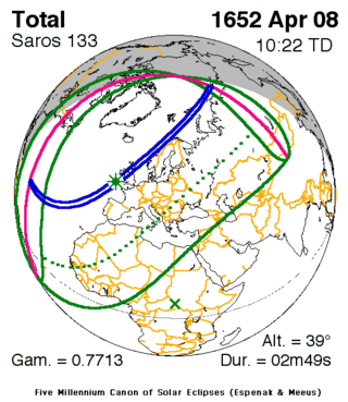
| Nature | Total |
| Gamma | 0.7713 |
| Magnitude | 1.0412 |
| Maximum eclipse | |
| Duration | 169 sec (2 m 49 s) |
| Coordinates | 49°36′N 8°54′W / 49.6°N 8.9°W |
| Max. width of band | 213 km (132 mi) |
| Times (UTC) | |
| Greatest eclipse | 10:22:28 |
| References | |
| Saros | 133 (25 of 72) |
| Catalog # (SE5000) | 8666 |
A total solar eclipse occurred on April 8, 1652. A solar eclipse occurs when the Moon passes between Earth and the Sun, thereby totally or partly obscuring the image of the Sun for a viewer on Earth. A total solar eclipse occurs when the Moon's apparent diameter is larger than the Sun's, blocking all direct sunlight, turning day into darkness. Totality occurs in a narrow path across Earth's surface, with the partial solar eclipse visible over a surrounding region thousands of kilometres wide. The path of totality intersected the United Kingdom, as well as passing just off the west coast of Norway.
Observations
Observed from Carrickfergus, Scotland, Dr. Wyberg wrote:
- "[The Sun was reduced] to a very slender crescent of light, the Moon all at once threw herself within the margin of the solar disc with such agility that she seemed to revolve like an upper millstone, affording a pleasant spectacle of rotatory motion."[1]
Because this eclipse occurred on a Monday that day became popularly known as Mirk Monday.[2]
Related eclipses
It is a part of solar Saros 133.
See also
Notes
- ↑ Solar Eclipse newsletter, April 2003
- ↑ Mairi Robinson (editor)Concise Scottish Dictionary, (1985), "mirk", p.416.
References
| Wikimedia Commons has media related to Solar eclipse of 1652 April 8. |

