Solukhumbu District
| Solukhumbu सोलुखुम्बु | |
|---|---|
| District | |
|
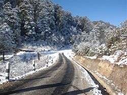
A road section in Solukhumbu. | |
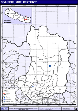
 Solukhumbu is located in the north of Nepal | |
| Country | Nepal |
| Region | Eastern (Purwanchal) |
| Zone | Sagarmatha |
| Headquarters | Salleri |
| Area | |
| • Total | 3,312 km2 (1,279 sq mi) |
| Population (2011) | |
| • Total | 105,886[1] |
| Time zone | NPT (UTC+5:45) |
Solukhumbu District (Nepali: सोलुखुम्बु जिल्ला![]() listen , Sherpa: ཤར་ཁུམ་བུ་རྫོང་ཁ། Wylie: shar khum bu dzong kha), a part of the Province No. 1, is one of the seventy-five districts of Nepal, a landlocked country of South Asia. As the name suggests, it consists of the subregions Solu and Khumbu.
listen , Sherpa: ཤར་ཁུམ་བུ་རྫོང་ཁ། Wylie: shar khum bu dzong kha), a part of the Province No. 1, is one of the seventy-five districts of Nepal, a landlocked country of South Asia. As the name suggests, it consists of the subregions Solu and Khumbu.
The district, with Salleri as its headquarters, covers an area of 3,312 km² and had a population 107,686 in 2001 and 105,886 in 2011.[1]
Mount Everest is in the northern part of this district, within Sagarmatha National Park.
Indigenous ethnic Rai and hill Caste Chhetri are the main groups living in the mid-hills, while Sherpas occupy high mountains. There is a notable hiking trail known as the Solukhumbu Trail.

Tourism
Solukhumbu District is a familiar name in mountain tourism. The main attraction is Mount Everest (8,848m). UNESCO has listed the Sagarmatha National Park as a World Heritage site. Sherpa culture and Tengboche Monastery are unique to this district. The Khumjung village is famous for Sherpa culture. Gokyo valley and Khumbu valley are the major Himalayan valleys famous among the adventure and nature seekers. Gokyo Lake trek, Island peak climbing, solukhumbu, Mera Peak climbing, Mount Everest Exepedition, Amadablam expedition, and Lobuche peak climbing are the popular adventure trips in Solukhumbu district. This district is well known for adventure holidays.
Geography and climate
| Climate Zone[2] | Elevation Range | % of Area |
|---|---|---|
| Upper Tropical | 300 to 1,000 meters 1,000 to 3,300 ft. |
0.7% |
| Subtropical | 1,000 to 2,000 meters 3,300 to 6,600 ft. |
9.3% |
| Temperate | 2,000 to 3,000 meters 6,400 to 9,800 ft. |
20.6% |
| Subalpine | 3,000 to 4,000 meters 9,800 to 13,100 ft. |
16.6% |
| Alpine | 4,000 to 5,000 meters 13,100 to 16,400 ft. |
28.3% |
| Nival | above 5,000 meters | 24.4% |
Village Development Committees (VDCs) and Municipalities
There are 35 Village Development Committees in Solukhumbu District:[3]
- Bapha
- Baku
- Basa
- Beni
- Bhakanje
- Bung
- Chaulakharka
- Chaurikharka
- Chheskam
- Deusa
- Dudhkunda Municipality
- Garma
- Goli
- Gorakhani
- Gudel
- Jubing
- Jubu
- Kaku
- Kangel
- Kerung
- Khumjung
- Loding Tamakhani
- Lokhim
- Mabe
- Mukali
- Namche
- Necha Batase
- Necha Bedghari
- Nele
- Panchan
- Salleri
- Salyan
- Sotang
- Takasindu
- Tapting
- Tingla
See also
References
- 1 2 "Districts of Nepal". Statoids.
- ↑ The Map of Potential Vegetation of Nepal - a forestry/agroecological/biodiversity classification system (PDF), Forest & Landscape Development and Environment Series 2-2005 and CFC-TIS Document Series No.110., 2005, ISBN 87-7903-210-9, retrieved Nov 22, 2013 horizontal tab character in
|series=at position 89 (help) - ↑ Nepal Census 2001
Coordinates: 27°30′N 86°35′E / 27.500°N 86.583°E
| Wikimedia Commons has media related to Solukhumbu District. |