South Lancaster, Massachusetts
| South Lancaster, Massachusetts | |
|---|---|
| CDP | |
|
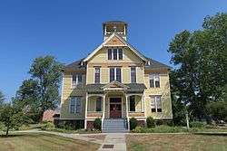
Founders Hall, Atlantic Union College | |
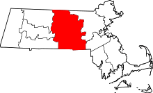
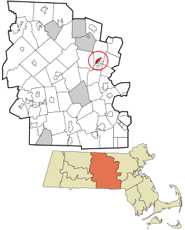 Location in Worcester County and the state of Massachusetts. | |
| Coordinates: 42°26′16″N 71°41′18″W / 42.43778°N 71.68833°WCoordinates: 42°26′16″N 71°41′18″W / 42.43778°N 71.68833°W | |
| Country | United States |
| State | Massachusetts |
| County | Worcester |
| Area | |
| • Total | 1.3 sq mi (3.4 km2) |
| • Land | 1.3 sq mi (3.4 km2) |
| • Water | 0.0 sq mi (0.0 km2) |
| Elevation | 285 ft (87 m) |
| Population (2010) | |
| • Total | 1,894 |
| • Density | 1,500/sq mi (560/km2) |
| Time zone | Eastern (EST) (UTC-5) |
| • Summer (DST) | EDT (UTC-4) |
| ZIP code | 01561 |
| Area code(s) | 978 |
| FIPS code | 25-64460 |
| GNIS feature ID | 0610918 |
South Lancaster is a census-designated place (CDP) in the town of Lancaster and close to the Town of Clinton in Worcester County, Massachusetts, United States. The population was 1,894 at the 2010 census.
Geography
South Lancaster is located at 42°26′16″N 71°41′18″W / 42.43778°N 71.68833°W (42.437841, -71.688444).[1]
According to the United States Census Bureau, the CDP has a total area of 3.4 km² (1.3 mi²). 3.4 km² (1.3 mi²) of it is land and 0.76% is water.
Demographics
As of the census[2] of 2000, there were 1,742 people, 676 households, and 469 families residing in the CDP. The population density was 517.4/km² (1,334.9/mi²), amongst the lowest in the state. There were 695 housing units at an average density of 206.4/km² (532.6/mi²). The racial makeup of the CDP was 90.30% White, 6.43% African American, 0.06% Native American, 1.26% Asian, 1.49% from other races, and 0.46% from two or more races. Hispanic or Latino of any race were 5.45% of the population.
There were 676 households out of which 32.7% had children under the age of 18 living with them, 57.0% were married couples living together, 8.7% had a female householder with no husband present, and 30.6% were non-families. 25.1% of all households were made up of individuals and 14.5% had someone living alone who was 65 years of age or older. The average household size was 2.58 and the average family size was 3.11.
In the CDP the population was spread out with 24.9% under the age of 18, 6.6% from 18 to 24, 30.4% from 25 to 44, 24.2% from 45 to 64, and 14.0% who were 65 years of age or older. The median age was 39 years. For every 100 females there were 93.6 males. For every 100 females age 18 and over, there were 84.6 males.
The median income for a household in the CDP was $48,750, and the median income for a family was $56,319. Males had a median income of $41,917 versus $31,429 for females. The per capita income for the CDP was $23,341. About 4.6% of families and 5.3% of the population were below the poverty line, including 1.9% of those under age 18 and 23.3% of those age 65 or over.
Religion and education
A significant portion of life in the village centers around Atlantic Union College, a Seventh-day Adventist institution of higher learning founded in 1882. The college is currently rebuilding after losing accreditation in 2011. The village is home to the Southern New England Conference of Seventh-day Adventists and the Atlantic Union Conference of Seventh-day Adventists. The college music department is housed in the Nathaniel Thayer Estate, which was placed on the National Register of Historic Places in 1976 and is now the Thayer Performing Arts Center.
References
- ↑ "US Gazetteer files: 2010, 2000, and 1990". United States Census Bureau. 2011-02-12. Retrieved 2011-04-23.
- ↑ "American FactFinder". United States Census Bureau. Retrieved 2008-01-31.