Paxton, Massachusetts
| Paxton, Massachusetts | ||
|---|---|---|
| Town | ||
|
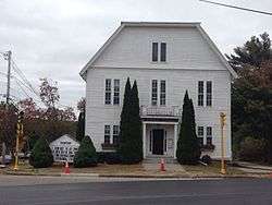
Paxton Town Hall | ||
| ||
| Motto: "A Rural Town Community"[1] | ||
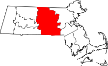
 Location in Worcester County and the state of Massachusetts. | ||
| Coordinates: 42°18′40″N 71°55′43″W / 42.31111°N 71.92861°WCoordinates: 42°18′40″N 71°55′43″W / 42.31111°N 71.92861°W | ||
| Country | United States | |
| State | Massachusetts | |
| County | Worcester | |
| Settled | 1749 | |
| Incorporated | 1765 | |
| Government | ||
| • Type | Open town meeting | |
| • Town Administrator | Carol Riches | |
| • Board of Selectmen |
Peter Bogren, Jr. John F. Malone Julia Pingitore | |
| Area | ||
| • Total | 15.5 sq mi (40.1 km2) | |
| • Land | 14.7 sq mi (38.2 km2) | |
| • Water | 0.7 sq mi (1.9 km2) | |
| Elevation | 1,158 ft (353 m) | |
| Population (2010) | ||
| • Total | 4,806 | |
| • Density | 310/sq mi (120/km2) | |
| Time zone | Eastern (UTC-5) | |
| • Summer (DST) | Eastern (UTC-4) | |
| ZIP code | 01612 | |
| Area code(s) | 508 / 774 | |
| FIPS code | 25-52420 | |
| GNIS feature ID | 0619485 | |
| Website | Town of Paxton, Massachusetts | |
Paxton is a town in Worcester County, Massachusetts, United States. The population was 4,806 at the 2010 census.
History
Paxton was first settled in 1749 and was officially incorporated in 1765.
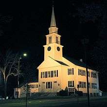
The district of Paxton was originally taken from the towns of Leicester and Rutland, in nearly equal parts, and was incorporated February 12, 1765. Charles Paxton, marshal of the Admiralty Court, offered a church bell to the town if it was named after him; no such gift was ever made.[2][3] The inhabitants soon commenced their plan for building a meeting house, and on the first day of April 1765, the town voted to build it. It was raised on 18 June 1766, and this is the frame of the present meeting house.
In 1766, within two years of the incorporation of the town, the foundation of the present meeting house was laid, on what is now the common, near the flagstaff. The land was given by Seth Howe, from a piece of his pasture.
David Davis went to Boston with a pair of oxen and drew to Paxton the bell now in use, which was made by Paul Revere.
A small historic and now defunct amusement park called "Paxton Yard" operated here in the mid 20th century.
Mount Asnebumskit was the site of the Yankee Network's early FM broadcasting antenna, beginning its commercial operations in Summer 1939.[4]
Geography
According to the United States Census Bureau, the town has a total area of 15.5 square miles (40 km2), of which 14.7 square miles (38 km2) is land and 0.7 square miles (1.8 km2), or 4.78%, is water.
Adjacent cities and towns
 |
Oakham | Rutland | Holden | |
| Spencer | |
|||
| ||||
| | ||||
| Leicester | Worcester |
Demographics
| Historical population | ||
|---|---|---|
| Year | Pop. | ±% |
| 1850 | 820 | — |
| 1860 | 725 | −11.6% |
| 1870 | 646 | −10.9% |
| 1880 | 592 | −8.4% |
| 1890 | 445 | −24.8% |
| 1900 | 459 | +3.1% |
| 1910 | 416 | −9.4% |
| 1920 | 489 | +17.5% |
| 1930 | 672 | +37.4% |
| 1940 | 791 | +17.7% |
| 1950 | 1,066 | +34.8% |
| 1960 | 2,399 | +125.0% |
| 1970 | 3,731 | +55.5% |
| 1980 | 3,762 | +0.8% |
| 1990 | 4,047 | +7.6% |
| 2000 | 4,386 | +8.4% |
| 2010 | 4,806 | +9.6% |
| * = population estimate. Source: United States Census records and Population Estimates Program data.[5][6][7][8][9][10][11][12][13][14] | ||
As of the census[15] of 2000, there were 4,386 people, 1,428 households, and 1,153 families residing in the town. The population density was 297.7 inhabitants per square mile (114.9/km2). There were 1,461 housing units at an average density of 99.2 per square mile (38.3/km2). The racial makeup of the town was 96.69% White, 0.68% African American, 0.09% Native American, 1.07% Asian, 0.57% from other races, and 0.89% from two or more races. Hispanic or Latino of any race were 1.55% of the population.
There were 1,428 households out of which 36.1% had children under the age of 18 living with them, 72.1% were married couples living together, 6.0% had a female householder with no husband present, and 19.2% were non-families. 15.7% of all households were made up of individuals and 8.3% had someone living alone who was 65 years of age or older. The average household size was 2.79 and the average family size was 3.13.
In the town the population was spread out with 23.9% under the age of 18, 13.6% from 18 to 24, 23.9% from 25 to 44, 24.0% from 45 to 64, and 14.6% who were 65 years of age or older. The median age was 38 years. For every 100 females there were 91.5 males. For every 100 females age 18 and over, there were 87.0 males.
The median income for a household in the town was $72,039, and the median income for a family was $80,498. Males had a median income of $51,694 versus $38,409 for females. The per capita income for the town was $29,573. None of the families and 1.8% of the population were living below the poverty line, including no under eighteens and 4.5% of those over 64.
| County-level state agency heads | |
|---|---|
| Clerk of Courts: | Dennis P. McManus (D) |
| District Attorney: | Joseph D. Early, Jr. (D) |
| Register of Deeds: | Anthony J. Vigliotti (D) |
| Register of Probate: | Stephanie K. Fattman (R) |
| County Sheriff: | Lew Evangelidis (R) |
| State government | |
| State Representative(s): | Kimberly N. Ferguson (R) |
| State Senator(s): | Anne Gobi (D) |
| Governor's Councilor(s): | Jen Caissie (R) |
| Federal government | |
| U.S. Representative(s): | James P. McGovern (D-2nd District) |
| U.S. Senators: | Elizabeth Warren (D), Ed Markey (D) |
Arts and culture
Points of interest
- Moore State Park
- Worcester County Memorial Park
- Thompson Pond (Massachusetts)
Education
- Anna Maria College's main campus is in Paxton, and the college recently opened a new campus in Worcester.
- Paxton is a member of the Wachusett Regional School District.
- Paxton Center School is the town's kindergarten, elementary and middle school (K-8).
- The public high school is Wachusett Regional High School, in Holden, Massachusetts.
- As of 2005, high school students may choose to attend Bay Path Regional Vocational Technical High School.
- Paxton Center School offers band, chorus and track to students in grades 5-8. All students participate in physical education, art education and technology classes.
Library
The Paxton public library began in 1877.[16][17] In fiscal year 2008, the town of Paxton spent 1.53% ($143,354) of its budget on its public library—some $30 per person.[18]
Infrastructure

Utilities
- Electric service is provided by the town's own municipal light department.
- Water service is provided by the town's own water department. Paxton's principal source of drinking water is Asnebumskit Pond. Recently, Paxton sells the raw Asnebumskit Pond water to Worcester, and buys back water treated at Worcester's filtration plant.
- Telephone service is provided by Verizon. All phones in Paxton are connected to Verizon's main central office in Worcester.
- Cable television service is provided by Charter Communications.
- No natural gas or sewer service is available in Paxton. At least one house on the Paxton-Worcester city line is connected to the Worcester sewer system. Paxton residents voted down the creation of the South Paxton Sewer District at a February 28, 2006 town meeting. This district would have installed sewers in the part of Paxton adjacent to Worcester.
Notable people
- Ralph Earl, portrait painter
- David Goodman, Medal of Honor recipient
References
- ↑ "Town of Paxton, Massachusetts". Town of Paxton, Massachusetts. Retrieved August 29, 2012.
- ↑ "Profile for Paxton, Massachusetts, MA". ePodunk. Retrieved October 23, 2015.
- ↑ "What's in a name? The story behind Paxton". The Landmark. Retrieved June 26, 2013.
- ↑ Lawrence Lessing (1969), Man of High Fidelity: Edwin Howard Armstrong, revised edition, New York: Bantam, Ch.12, "The Defender of the Human Ear", pp. 194-195.
- ↑ "TOTAL POPULATION (P1), 2010 Census Summary File 1". American FactFinder, All County Subdivisions within Massachusetts. United States Census Bureau. 2010.
- ↑ "Massachusetts by Place and County Subdivision - GCT-T1. Population Estimates". United States Census Bureau. Retrieved July 12, 2011.
- ↑ "1990 Census of Population, General Population Characteristics: Massachusetts" (PDF). US Census Bureau. December 1990. Table 76: General Characteristics of Persons, Households, and Families: 1990. 1990 CP-1-23. Retrieved July 12, 2011.
- ↑ "1980 Census of the Population, Number of Inhabitants: Massachusetts" (PDF). US Census Bureau. December 1981. Table 4. Populations of County Subdivisions: 1960 to 1980. PC80-1-A23. Retrieved July 12, 2011.
- ↑ "1950 Census of Population" (PDF). Bureau of the Census. 1952. Section 6, Pages 21-10 and 21-11, Massachusetts Table 6. Population of Counties by Minor Civil Divisions: 1930 to 1950. Retrieved July 12, 2011.
- ↑ "1920 Census of Population" (PDF). Bureau of the Census. Number of Inhabitants, by Counties and Minor Civil Divisions. Pages 21-5 through 21-7. Massachusetts Table 2. Population of Counties by Minor Civil Divisions: 1920, 1910, and 1920. Retrieved July 12, 2011.
- ↑ "1890 Census of the Population" (PDF). Department of the Interior, Census Office. Pages 179 through 182. Massachusetts Table 5. Population of States and Territories by Minor Civil Divisions: 1880 and 1890. Retrieved July 12, 2011.
- ↑ "1870 Census of the Population" (PDF). Department of the Interior, Census Office. 1872. Pages 217 through 220. Table IX. Population of Minor Civil Divisions, &c. Massachusetts. Retrieved July 12, 2011.
- ↑ "1860 Census" (PDF). Department of the Interior, Census Office. 1864. Pages 220 through 226. State of Massachusetts Table No. 3. Populations of Cities, Towns, &c. Retrieved July 12, 2011.
- ↑ "1850 Census" (PDF). Department of the Interior, Census Office. 1854. Pages 338 through 393. Populations of Cities, Towns, &c. Retrieved July 12, 2011.
- ↑ "American FactFinder". United States Census Bureau. Retrieved 2008-01-31.
- ↑ C.B. Tillinghast. The free public libraries of Massachusetts. 1st Report of the Free Public Library Commission of Massachusetts. Boston: Wright & Potter, 1891. Google books
- ↑ Richards Memorial Library. Retrieved 2010-11-10
- ↑ July 1, 2007 through June 30, 2008; cf. The FY2008 Municipal Pie: What’s Your Share? Commonwealth of Massachusetts, Board of Library Commissioners. Boston: 2009. Available: Municipal Pie Reports. Retrieved 2010-08-04
External links
| Wikimedia Commons has media related to Paxton, Massachusetts. |
- Town of Paxton, Massachusetts
- Wachusett Regional School District
- Bay Path Regional Vocational Technical High School