Templeton, Massachusetts
| Templeton, Massachusetts | ||
|---|---|---|
| Town | ||
|
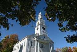
First Church of Templeton | ||
| ||
| Motto: "Industry" | ||
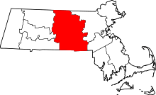
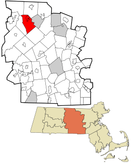 Location in Worcester County and the state of Massachusetts. | ||
| Coordinates: 42°33′20″N 72°04′05″W / 42.55556°N 72.06806°WCoordinates: 42°33′20″N 72°04′05″W / 42.55556°N 72.06806°W | ||
| Country | United States | |
| State | Massachusetts | |
| County | Worcester | |
| Settled | 1751 | |
| Incorporated | 1762 | |
| Government | ||
| • Type | Open town meeting | |
| Area | ||
| • Total | 32.4 sq mi (83.9 km2) | |
| • Land | 32.0 sq mi (83.0 km2) | |
| • Water | 0.4 sq mi (1.0 km2) | |
| Elevation | 1,141 ft (348 m) | |
| Population (2010) | ||
| • Total | 8,013 | |
| • Density | 250/sq mi (96/km2) | |
| Time zone | Eastern (UTC-5) | |
| • Summer (DST) | Eastern (UTC-4) | |
| ZIP code | 01436 | |
| Area code(s) | 351 / 978 | |
| FIPS code | 25-69275 | |
| GNIS feature ID | 0619492 | |
| Website | www.templeton1.org | |

Templeton is a town in Worcester County, Massachusetts, United States. The population was 8,013 at the 2010 census. The town comprises four main villages: Templeton Center, East Templeton, Baldwinville, and Otter River. It is the home of Narragansett Regional High School, a regional public high school serving the towns of Templeton and Phillipston.
Geography
According to the United States Census Bureau, the town has a total area of 32.4 square miles (84 km2), of which 32.0 square miles (83 km2) is land and 0.4 square miles (1.0 km2), or 1.17%, is water.
Templeton is bordered by Royalston and Winchendon to the north, Gardner to the east, Hubbardston to the southeast, and Phillipston to the west.
Demographics
| Historical population | ||
|---|---|---|
| Year | Pop. | ±% |
| 1850 | 2,173 | — |
| 1860 | 2,816 | +29.6% |
| 1870 | 2,802 | −0.5% |
| 1880 | 2,789 | −0.5% |
| 1890 | 2,999 | +7.5% |
| 1900 | 3,489 | +16.3% |
| 1910 | 3,756 | +7.7% |
| 1920 | 4,019 | +7.0% |
| 1930 | 4,159 | +3.5% |
| 1940 | 4,601 | +10.6% |
| 1950 | 4,757 | +3.4% |
| 1960 | 5,371 | +12.9% |
| 1970 | 5,863 | +9.2% |
| 1980 | 6,070 | +3.5% |
| 1990 | 6,438 | +6.1% |
| 2000 | 6,799 | +5.6% |
| 2010 | 8,013 | +17.9% |
| * = population estimate. Source: United States Census records and Population Estimates Program data.[1][2][3][4][5][6][7][8][9][10] | ||
As of the census[11] of 2000, there were 6,799 people, 2,411 households, and 1,808 families residing in the town. The population density was 212.2 people per square mile (81.9/km²). There were 2,597 housing units at an average density of 81.1 per square mile (31.3/km²). The racial makeup of the town was 98.15% White, 0.35% African American, 0.22% Native American, 0.28% Asian, 0.43% from other races, and 0.57% from two or more races. Hispanic or Latino of any race were 1.44% of the population. 19.2% were of French, 13.3% French Canadian, 12.8% Irish, 10.1% Italian, 9.6% English, 8.0% Polish, 5.4% Finnish and 5.4% American ancestry according to Census 2000.
There were 2,411 households out of which 35.3% had children under the age of 18 living with them, 60.5% were married couples living together, 9.4% had a female householder with no husband present, and 25.0% were non-families. 19.7% of all households were made up of individuals and 9.5% had someone living alone who was 65 years of age or older. The average household size was 2.71 and the average family size was 3.09.
In the town the population was spread out with 26.1% under the age of 18, 6.0% from 18 to 24, 31.1% from 25 to 44, 23.9% from 45 to 64, and 12.9% who were 65 years of age or older. The median age was 38 years. For every 100 females there were 101.0 males. For every 100 females age 18 and over, there were 99.2 males.
The median income for a household in the town was $48,482, and the median income for a family was $52,936. Males had a median income of $38,088 versus $26,993 for females. The per capita income for the town was $21,994. About 7.4% of families and 9.1% of the population were below the poverty line, including 10.5% of those under age 18 and 13.4% of those age 65 or over.
Government
| County-level state agency heads | |
|---|---|
| Clerk of Courts: | Dennis P. McManus (D) |
| District Attorney: | Joseph D. Early, Jr. (D) |
| Register of Deeds: | Anthony J. Vigliotti (D) |
| Register of Probate: | Stephanie K. Fattman (R) |
| County Sheriff: | Lew Evangelidis (R) |
| State government | |
| State Representative(s): | Susannah Whipps Lee (R) |
| State Senator(s): | Anne Gobi (D) |
| Governor's Councilor(s): | Jen Caissie (R) |
| Federal government | |
| U.S. Representative(s): | James P. McGovern (D-2nd District), |
| U.S. Senators: | Elizabeth Warren (D), Ed Markey (D) |
Library
Templeton's Boynton Public Library began in 1868.[12][13] In fiscal year 2008, the town of Templeton spent 0.49% ($53,608) of its budget on its public library—some $6 per person.[14]
Notable people
- Stephen Pearl Andrews (1812-1886), individualist anarchist[15]
- George E. Bryant (1832-1907), Wisconsin legislator and general
- William Goodell (1792-1867), missionary and linguist, the first to translate the Bible into Armeno-Turkish
- Sarah Goodridge (1788–1853), painter
- Elizabeth Goodridge (1798-1882), miniaturist, Sarah's sister
- Mike Kelley (1875–1955), baseball player
- Charles Knowlton (1800-1850), physician, atheist, and writer
- Pliny Norcross (1838-1915), Wisconsin legislator and lawyer
- Sylvanus Sawyer (1822-1895), inventor and businessman
- Jonathan Baldwin Turner (1805-1899), classical scholar, botanist, dedicated Christian, and political activist
- Charlotte Frances Wilder (1839-1916), writer
Sites of interest
- Templeton Developmental Center, Department of Mental Health, a state-operated facility for individuals with mental health issues
- Otter River State Forest, operated by the Massachusetts Department of Conservation and Recreation. Located on Beamon Pond, it includes 85 campsites, a swimming beach, picnic areas and a ball field.
References
- ↑ "TOTAL POPULATION (P1), 2010 Census Summary File 1". American FactFinder, All County Subdivisions within Massachusetts. United States Census Bureau. 2010.
- ↑ "Massachusetts by Place and County Subdivision - GCT-T1. Population Estimates". United States Census Bureau. Retrieved July 12, 2011.
- ↑ "1990 Census of Population, General Population Characteristics: Massachusetts" (PDF). US Census Bureau. December 1990. Table 76: General Characteristics of Persons, Households, and Families: 1990. 1990 CP-1-23. Retrieved July 12, 2011.
- ↑ "1980 Census of the Population, Number of Inhabitants: Massachusetts" (PDF). US Census Bureau. December 1981. Table 4. Populations of County Subdivisions: 1960 to 1980. PC80-1-A23. Retrieved July 12, 2011.
- ↑ "1950 Census of Population" (PDF). Bureau of the Census. 1952. Section 6, Pages 21-10 and 21-11, Massachusetts Table 6. Population of Counties by Minor Civil Divisions: 1930 to 1950. Retrieved July 12, 2011.
- ↑ "1920 Census of Population" (PDF). Bureau of the Census. Number of Inhabitants, by Counties and Minor Civil Divisions. Pages 21-5 through 21-7. Massachusetts Table 2. Population of Counties by Minor Civil Divisions: 1920, 1910, and 1920. Retrieved July 12, 2011.
- ↑ "1890 Census of the Population" (PDF). Department of the Interior, Census Office. Pages 179 through 182. Massachusetts Table 5. Population of States and Territories by Minor Civil Divisions: 1880 and 1890. Retrieved July 12, 2011.
- ↑ "1870 Census of the Population" (PDF). Department of the Interior, Census Office. 1872. Pages 217 through 220. Table IX. Population of Minor Civil Divisions, &c. Massachusetts. Retrieved July 12, 2011.
- ↑ "1860 Census" (PDF). Department of the Interior, Census Office. 1864. Pages 220 through 226. State of Massachusetts Table No. 3. Populations of Cities, Towns, &c. Retrieved July 12, 2011.
- ↑ "1850 Census" (PDF). Department of the Interior, Census Office. 1854. Pages 338 through 393. Populations of Cities, Towns, &c. Retrieved July 12, 2011.
- ↑ "American FactFinder". United States Census Bureau. Retrieved 2008-01-31.
- ↑ C.B. Tillinghast. The free public libraries of Massachusetts. 1st Report of the Free Public Library Commission of Massachusetts. Boston: Wright & Potter, 1891.
- ↑ http://boyntonpubliclibrary.org/ Retrieved 2010-11-10
- ↑ July 1, 2007 through June 30, 2008; cf. The FY2008 Municipal Pie: What’s Your Share? Commonwealth of Massachusetts, Board of Library Commissioners. Boston: 2009. Available: Municipal Pie Reports. Retrieved 2010-08-04
- ↑ Who Was Who in America, Historical Volume, 1607-1896. Marquis Who's Who. 1967.
External links
| Wikimedia Commons has media related to Templeton, Massachusetts. |