Oakham, Massachusetts
| Oakham, Massachusetts | ||
|---|---|---|
| Town | ||
|
Town Center | ||
| ||
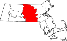
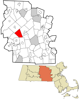 Location in Worcester County and the state of Massachusetts. | ||
| Coordinates: 42°21′10″N 72°02′45″W / 42.35278°N 72.04583°WCoordinates: 42°21′10″N 72°02′45″W / 42.35278°N 72.04583°W | ||
| Country | United States | |
| State | Massachusetts | |
| County | Worcester | |
| Settled | 1749 | |
| Incorporated | 1775 | |
| Government | ||
| • Type | Open town meeting | |
| Area | ||
| • Total | 21.5 sq mi (55.8 km2) | |
| • Land | 21.1 sq mi (54.7 km2) | |
| • Water | 0.4 sq mi (1.1 km2) | |
| Elevation | 1,050 ft (320 m) | |
| Population (2010) | ||
| • Total | 1,902 | |
| • Density | 88/sq mi (34/km2) | |
| Time zone | Eastern (UTC-5) | |
| • Summer (DST) | Eastern (UTC-4) | |
| ZIP code | 01068 | |
| Area code(s) | 508 / 774 | |
| FIPS code | 25-50670 | |
| GNIS feature ID | 0618378 | |
| Website | www.oakham-ma.gov | |


Oakham is a town in Worcester County, Massachusetts, United States. The population was 1,902 at the 2010 census.
History
Oakham was first settled in 1749 as part of Rutland, and was officially incorporated in 1762. It was originally named Oakhampton, but the name was changed for an unknown reason.
The village of Coldbrook Springs is part of Oakham, near the Barre line.
Geography
According to the United States Census Bureau, the town has a total area of 21.5 square miles (56 km2), of which 21.1 square miles (55 km2) is land and 0.4 square miles (1.0 km2), or 1.90%, is water.
Oakham is bordered by Barre to the northwest, Rutland to the northeast, Paxton to the southeast, Spencer to the south, and New Braintree to the southwest. The towns of Oakham, New Braintree, Spencer and North Brookfield share a common town corner; however, due to its location within feet of the banks of Brooks Pond, there is no direct way to get to North Brookfield from Oakham.
Demographics
| Historical population | ||
|---|---|---|
| Year | Pop. | ±% |
| 1850 | 1,137 | — |
| 1860 | 959 | −15.7% |
| 1870 | 860 | −10.3% |
| 1880 | 869 | +1.0% |
| 1890 | 738 | −15.1% |
| 1900 | 588 | −20.3% |
| 1910 | 552 | −6.1% |
| 1920 | 477 | −13.6% |
| 1930 | 502 | +5.2% |
| 1940 | 423 | −15.7% |
| 1950 | 455 | +7.6% |
| 1960 | 524 | +15.2% |
| 1970 | 730 | +39.3% |
| 1980 | 994 | +36.2% |
| 1990 | 1,503 | +51.2% |
| 2000 | 1,673 | +11.3% |
| 2010 | 1,902 | +13.7% |
| * = population estimate. Source: United States Census records and Population Estimates Program data.[1][2][3][4][5][6][7][8][9][10] | ||
As of the census[11] of 2000, there were 1,673 people, 578 households, and 467 families residing in the town. The population density was 79.2 people per square mile (30.6/km²). There were 591 housing units at an average density of 28.0 per square mile (10.8/km²). The racial makeup of the town was 98.33% White, 0.36% African American, 0.12% Native American, 0.60% Asian, 0.24% from other races, and 0.36% from two or more races. Hispanic or Latino of any race were 1.02% of the population.
There were 578 households out of which 41.5% had children under the age of 18 living with them, 71.5% were married couples living together, 6.4% had a female householder with no husband present, and 19.2% were non-families. Of all households 14.7% were made up of individuals and 5.2% had someone living alone who was 65 years of age or older. The average household size was 2.89 and the average family size was 3.24.
In the town the population was spread out with 29.6% under the age of 18, 6.0% from 18 to 24, 29.0% from 25 to 44, 27.5% from 45 to 64, and 7.8% who were 65 years of age or older. The median age was 38 years. For every 100 females there were 100.4 males. For every 100 females age 18 and over, there were 99.8 males.
The median income for a household in the town was $60,729, and the median income for a family was $63,487. Males had a median income of $42,065 versus $30,882 for females. The per capita income for the town was $23,175. About 1.5% of families and 1.9% of the population were below the poverty line, including 1.8% of those under age 18 and 2.2% of those age 65 or over.
Government
| County-level state agency heads | |
|---|---|
| Clerk of Courts: | Dennis P. McManus (D) |
| District Attorney: | Joseph D. Early, Jr. (D) |
| Register of Deeds: | Anthony J. Vigliotti (D) |
| Register of Probate: | Stephanie K. Fattman (R) |
| County Sheriff: | Lew Evangelidis (R) |
| State government | |
| State Representative(s): | Donnie Berthiaume (R) |
| State Senator(s): | Anne M. Gobi (D) |
| Governor's Councilor(s): | Jen Caissie (R) |
| Federal government | |
| U.S. Representative(s): | James P. McGovern (D-2nd District), |
| U.S. Senators: | Elizabeth Warren (D), Ed Markey (D) |
Library
The Oakham Free Public Library was established in 1892.[12][13] In fiscal year 2008, the town of Oakham spent 1.71% ($47,657) of its budget on its public library—some $24 per person.[14]
References
- ↑ "TOTAL POPULATION (P1), 2010 Census Summary File 1". American FactFinder, All County Subdivisions within Massachusetts. United States Census Bureau. 2010.
- ↑ "Massachusetts by Place and County Subdivision - GCT-T1. Population Estimates". United States Census Bureau. Retrieved July 12, 2011.
- ↑ "1990 Census of Population, General Population Characteristics: Massachusetts" (PDF). US Census Bureau. December 1990. Table 76: General Characteristics of Persons, Households, and Families: 1990. 1990 CP-1-23. Retrieved July 12, 2011.
- ↑ "1980 Census of the Population, Number of Inhabitants: Massachusetts" (PDF). US Census Bureau. December 1981. Table 4. Populations of County Subdivisions: 1960 to 1980. PC80-1-A23. Retrieved July 12, 2011.
- ↑ "1950 Census of Population" (PDF). Bureau of the Census. 1952. Section 6, Pages 21-10 and 21-11, Massachusetts Table 6. Population of Counties by Minor Civil Divisions: 1930 to 1950. Retrieved July 12, 2011.
- ↑ "1920 Census of Population" (PDF). Bureau of the Census. Number of Inhabitants, by Counties and Minor Civil Divisions. Pages 21-5 through 21-7. Massachusetts Table 2. Population of Counties by Minor Civil Divisions: 1920, 1910, and 1920. Retrieved July 12, 2011.
- ↑ "1890 Census of the Population" (PDF). Department of the Interior, Census Office. Pages 179 through 182. Massachusetts Table 5. Population of States and Territories by Minor Civil Divisions: 1880 and 1890. Retrieved July 12, 2011.
- ↑ "1870 Census of the Population" (PDF). Department of the Interior, Census Office. 1872. Pages 217 through 220. Table IX. Population of Minor Civil Divisions, &c. Massachusetts. Retrieved July 12, 2011.
- ↑ "1860 Census" (PDF). Department of the Interior, Census Office. 1864. Pages 220 through 226. State of Massachusetts Table No. 3. Populations of Cities, Towns, &c. Retrieved July 12, 2011.
- ↑ "1850 Census" (PDF). Department of the Interior, Census Office. 1854. Pages 338 through 393. Populations of Cities, Towns, &c. Retrieved July 12, 2011.
- ↑ "American FactFinder". United States Census Bureau. Archived from the original on September 11, 2013. Retrieved 2008-01-31.
- ↑ Report of the Free Public Library Commission of Massachusetts. v.9 (1899)
- ↑ Fobes Memorial Library
- ↑ July 1, 2007 through June 30, 2008; cf. The FY2008 Municipal Pie: What’s Your Share? Commonwealth of Massachusetts, Board of Library Commissioners. Boston: 2009. Available: Municipal Pie Reports. Retrieved 2010-08-04
Further reading
- Wright, Henry Parks (1914). Soldiers of Oakham, Massachusetts, in the Revolutionary War, the War of 1812 and the Civil War. New Haven: Tuttle, Morehouse & Taylor Press. Retrieved April 20, 2014.
External links
-
 Media related to Oakham, Massachusetts at Wikimedia Commons