Princes Motorway
| Princes Motorway F6 Freeway / Southern Freeway New South Wales | |
|---|---|
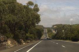 | |
| Princes Motorway near Helensburgh | |
| Coordinates | 34°24′5″S 150°52′21″E / 34.40139°S 150.87250°ECoordinates: 34°24′5″S 150°52′21″E / 34.40139°S 150.87250°E |
| General information | |
| Type | Motorway |
| Length | 55.4 km (34 mi)[1] |
| Opened | 1975–1987 |
| Route number(s) |
|
| Former route number |
|
| Major junctions | |
| North end | |
| |
| South end | |
| Location(s) | |
| Major suburbs / towns | Helensburgh, Wollongong, Figtree, Dapto |
| Highway system | |
|
Highways in Australia National Highway • Freeways in Australia Highways in New South Wales | |
| |
The Princes Motorway, formerly known as the Southern Freeway[2] is a 55-kilometre (34 mi)[1] predominately dual carriage untolled motorway that links Sydney to Wollongong and further south through the Illawarra region to Albion Park Rail. Part of the Australian Highway 1 network, the motorway is designated with the route number M1, having previously been signposted as F6 (Freeway Route 6) and is sometimes commonly known by this latter name.
As Wollongong and Port Kembla are important industrial centres, freight traffic is heavy. Despite the current decline of the local steel industry, emergence of Wollongong as a commuter city of Sydney has kept the freeway and the adjacent Mount Ousley Road busy.
History
In the north, the Princes Motorway route starts at Waterfall, taking more or less a parallel route with Princes Highway until the sprawling Bulli Tops interchange (with Appin Road (State Route 69) and Princes Highway). There it continues downhill, avoiding the steep Bulli Pass, and bypasses Wollongong CBD, through Gwynneville and continues for 20 kilometres (12 mi), bypassing the suburb of Yallah, and rejoining the Princes Highway north of Albion Park Rail near the Princes Highway junction with the Illawarra Highway.
From its opening on 24 July 1975, the Waterfall to Bulli Tops section of the then Southern Freeway incurred a toll.[3] This part of the freeway did not feature the Helensburgh Interchange (which subsequently opened in February 2000). The toll operated for 20 years, which was 10 years short of its intended operating length. The main reason for this was local residents complaining that the F3 Freeway (now Pacific Motorway) had their toll dropped in 1988, which was at the time intended to be dropped as its loans had been fully paid off unlike those of the F6.
After much pressure the toll for the F6 freeway was removed on 30 July 1995 as the loans had been repaid. Remnants of the tollbooths are still able to be seen at the old toll plaza at Waterfall. One of the lanes and very faint markings are still intact. Heading southbound one set of warning lights to slow down for the toll plaza are also still intact minus signage.
In early 2013, as part of the New South Wales alphanumeric route conversion process, the road name changed from the Southern Freeway to the Princes Motorway. The new name was also applied to what was formerly known as Mount Ousley Road.[4]
In November 2015, it was announced that the section between Bulli Tops and Picton Road would have a third lane added in each direction.[5]
Exits and interchanges

| LGA | Location | km | mi | Destinations | Notes |
|---|---|---|---|---|---|
| Sutherland | Waterfall | 0 | 0.0 | Northern terminus; continues north as the Princes Highway | |
| 0 | 0.0 | Princes Highway – Woronora Dam, Helensburgh | Northbound entrance and southbound exit only | ||
| Wollongong | Helensburgh | 6.7 | 4.2 | Exit to Lawrence Hargrave Drive – Helensburgh, Stanwell Tops, Stanwell Park, Otford | Southbound exit only |
| 7.1 | 4.4 | Entrance via Lawrence Hargrave Drive – Helensburgh, Stanwell Tops, Stanwell Park, Otford | Southbound entrance only | ||
| 7.4 | 4.6 | Princes Highway – Helensburgh, Stanwell Tops, Stanwell Park, Otford | Northbound entrance only | ||
| 7.8 | 4.8 | Princes Highway – Helensburgh, Stanwell Tops, Stanwell Park, Otford | Northbound exit only | ||
| Thirroul | 18.5 | 11.5 | Princes Highway – Sublime Point Lookout and Maddens Plains, Bulli, Corrimal | Southbound exit only | |
| 19.3 | 12.0 | Princes Highway – Sublime Point Lookout, Maddens Plains, Bulli and Corrimal | Southbound entrance only | ||
| 21 | 13 | Southbound exit and northbound entrance only | |||
| Balgownie | 30.1 | 18.7 | Northbound entrance only | ||
| 30.4 | 18.9 | Southbound and northbound exits only | |||
| 30.9 | 19.2 | Southbound entrance only | |||
| 31.3 | 19.4 | Clive Bissell Drive - Mount Keira | Northbound exit and entrance only | ||
| 34.2 | 21.3 | New Mount Pleasant Road - Balgownie, Fairy Meadow | Southbound exit only | ||
| Mount Ousley | 35.7 | 22.2 | Mount Ousley Road - Mount Ousley to Princes Highway and | Southbound exit only | |
| 35.8 | 22.2 | Mount Ousley Road - Mount Ousley from Princes Highway and | Northbound and southbound entrances only | ||
| Keiraville | 36.0 | 22.4 | Northfields Avenue - University of Wollongong, Keiraville, Gwynneville | Northbound entrance and northbound exit to both Northfields Avenue and Irvine Street only | |
| 36.2 | 22.5 | University Avenue - University of Wollongong, Keiraville, Gwynneville | Southbound exit and entrance only | ||
| Gwynneville | 36.5 | 22.7 | Northbound entrance and southbound entrance only | ||
| 36.8 | 22.9 | To | Southbound exit only | ||
| Mangerton | 38.7 | 24.0 | Princes Highway - Wollongong, Figtree | Northbound entrance and exit; southbound exit and entrance | |
| Figtree | 39.9 | 24.8 | Masters Drive - Spring Hill, Port Kembla, Wollongong | Northbound entrance and southbound exit only | |
| 40.6 | 25.2 | Masters Drive - Spring Hill, Port Kembla, Wollongong | Southbound entrance only | ||
| Unanderra | 42 | 26 | Five Islands Road - Unanderra, Port Kembla | Northbound entrance and exit; and southbound exit and entrance | |
| Berkeley | 45.1 | 28.0 | Northcliffe Drive - Kembla Grange, Warrawong, Port Kembla | Northbound entrance and exit; southbound exit and entrance | |
| Kanahooka | 47.8 | 29.7 | Kanahooka Road - Dapto, Kanahooka, Koonawarra | Northbound entrance and southbound exit only | |
| Dapto | 49.5 | 30.8 | Fowlers Road - Dapto, Koonawarra | Northbound entrance and southbound exit only | |
| Shellharbour | Yallah | 52.7 | 32.7 | Exit to Princes Highway – Yallah, Dapto | Northbound exit only |
| 53.3 | 33.1 | Princes Highway – Yallah, Dapto | Southbound entrance only | ||
| Haywards Bay | 54.3 | 33.7 | Yalla Road from Princes Highway; to Haywards Bay Drive – Haywards Bay | Northbound entrance and southbound exit only | |
| 54.7 | 34.0 | To Yalla Road; from Haywards Bay Drive – Haywards Bay | Northbound exit and southbound entrance only | ||
| Albion Park Rail | 55.4 | 34.4 | Southern terminus; continues south as the Princes Highway | ||
| 55.4 | 34.4 | Westbound as the | |||
| 1.000 mi = 1.609 km; 1.000 km = 0.621 mi | |||||
Proposed extension
_01.jpg)

The County of Cumberland Scheme of 1948 outlined an F6 extension from the current-day end-point at Waterfall.[6] As such, an F6 corridor was set aside that passes through the Royal National Park from Waterfall to Campbell Road in St Peters. The land reservation tract currently passes through the suburbs of Loftus, Kirrawee, Gymea, Miranda, Taren Point, Sandringham, Sans Souci, Ramsgate, Monterey, Kogarah, Brighton-Le-Sands, Rockdale, Banksia, Kyeemagh and Tempe.[7]
Of the proposed extension, only the six-lane Captain Cook Bridge and a short connecting section of Taren Point Road to the south have been built. Establishment of the bridge section of the F6 extension began in 1962, expedited to replace the ferry service that had operated from Taren Point to Sans Souci since 1916. Captain Cook Bridge was opened for general use in May 1965.[8]
In the original plan, the F6 would connect to the Western Distributor.[9] Then, in August 1977, premier Neville Wran cancelled the inner section of the F6 link, which at the time had an estimated construction cost of $96 million.[8] At the same time, Wran announced that the inner section reservation would be sold off and the proposed extension would instead terminate at St Peters, a medium density industrial suburb.[8][10][11]
Prior to the 2007 federal election, the Liberal-Nationals (Coalition) promised to allocate A$20 million towards planning for the F6 extension.[12] Although the Coalition did not win the 2007 election,[13] the funding was once again promised at the subsequent 2010 federal election. This funding would ensure the project is "shovel ready" when funding becomes available.[14]
As part of modifications made during the planning stage of the WestConnex project, stub tunnels will be added to the "New M5" tunnel to allow for an extension connection to it by the F6 extension.[15][16] In June 2016 the Roads & Maritime Services commenced geotechnical analysis to determine underground rock and soil conditions on the former F6 corridor from Waterfall to the Sydney Orbital Network at Rockdale with a view into developing a possible link between the Princes Motorway and the Orbital Network.[17] It was further reported in October 2016 that any extension would be known as SouthConnex.[18]
See also
References
- 1 2 "Princes Highway & A1 & M1 & Princes Motorway, New South Wales to 3-5 Princes Highway, Albion Park Rail NSW 2527". Google Maps. Google. 2016. Retrieved 11 October 2016.
- ↑ F6 Southern Freeway, Ozroads: the Australian Roads Website. Retrieved 24 August 2008.
- ↑ F6 Southern Freeway – Construction, Ozroads: the Australian Roads Website. Retrieved 24 August 2008.
- ↑ "Information for Southern NSW & ACT". Alpha-numeric route numbers. Roads and Maritime Services. 20 May 2013. Retrieved 13 June 2013.
- ↑ Humphries, Glen (2 November 2015). "Extra lanes for motorway between Picton Road and Bulli Tops". Illawarra Mercury. Archived from the original on 3 November 2015.
- ↑ "10 reasons for not building an F6 Motorway" (PDF). Sutherland Shire Environment Centre. 2005. Retrieved 30 August 2010.
- ↑ "F6 Corridor Public Transport Use Assessment" (PDF). Roads and Traffic Authority. September 2004. Retrieved 30 August 2010.
- 1 2 3 "F6 Southern Freeway : History and Development". Ozroads. Retrieved 30 August 2010.
- ↑ "Western Distributor - Construction Information". Retrieved 11 May 2011.
- ↑ Baker, Jordan (27 February 2007). "Shire will become car park unless F6 is built: NRMA". The Sydney Morning Herald. Retrieved 30 August 2010.
- ↑ Baker, Jordan (12 February 2007). "F6 extension – the great dividing road". The Sydney Morning Herald. Retrieved 30 August 2010.
- ↑ "$20 million worth of progress on F6". NRMA. 5 November 2007. Retrieved 30 August 2010.
- ↑ "Kevin Rudd claims victory in federal election". The Sydney Morning Herald. 24 November 2007. Retrieved 30 August 2010.
- ↑ Kelly, Craig; Morrison, Scott (2 August 2010). "Morrison/Kelly Announce $20 Million to Get F6 Extension Tunnel Shovel Ready". Liberal Party of Australia. Retrieved 30 August 2010.
- ↑ Saulwick, Jacob (3 September 2015). "Multimillion-dollar compensation brawl brews over WestConnex St Peters interchange". The Sydney Morning Herald. Retrieved 26 July 2016.
- ↑ "WestConnex – Updated Strategic Business Case" (PDF). Sydney Motorway Corporation. November 2015. ISBN 978-1-925421-39-2. Retrieved 26 July 2016.
- ↑ "Fact sheet: F6 Corridor Geotechnical Analysis" (PDF). Roads & Maritime Services. Government of New South Wales. June 2016. Retrieved 10 October 2016.
- ↑ Patterson, Ian (17 October 2016). "Sydney's missing F6 motor link to the south on road to reality". The Daily Telegraph. Retrieved 17 October 2016.