St. Joseph Parkway
|
St. Joseph Park and Parkway System | |
|
St. Joseph parkway, April 2016 | |
  | |
| Location | Roughly, along Northwest, Northeast, Corby Grove, Southwest and A Pkwys. and Noyes Blvd. from Krug Park to Hyde Park, St. Joseph, Missouri |
|---|---|
| Coordinates | 39°45′04″N 94°50′25″W / 39.75111°N 94.84028°WCoordinates: 39°45′04″N 94°50′25″W / 39.75111°N 94.84028°W |
| Area | 983 acres (398 ha) |
| Architect | Robinson, Charles Mulford; et al. |
| Architectural style | Renaissance |
| MPS | St. Joseph MPS |
| NRHP Reference # | 94001566[1] |
| Added to NRHP | January 20, 1995 |
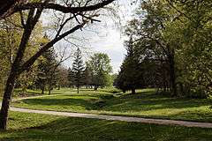
The St. Joseph Park and Parkway System is a national historic district located at St. Joseph, Missouri. It is St. Joseph, Missouri's hiking and biking Parkway ribbons through the city for 26 miles. Developed in 1918 by internationally known landscape architect George Burnap, St. Joseph was one of the first cities in the United States to develop a comprehensive parkway plan. Popular for hiking and biking activities, the completed system connects principal parks and recreation facilities, providing a "green belt" throughout the city.[2]
St. Joseph's Parkway system was listed in the National Register of Historic Places in 1994.
See also
References
- ↑ National Park Service (2010-07-09). "National Register Information System". National Register of Historic Places. National Park Service.
- ↑ Deon K. Wolfenbarger (April 1994). "National Register of Historic Places Inventory Nomination Form: St. Joseph Park and Parkway System" (PDF). Missouri Department of Natural Resources. Retrieved 2016-09-01.
External links

This article is issued from Wikipedia - version of the 11/26/2016. The text is available under the Creative Commons Attribution/Share Alike but additional terms may apply for the media files.