National Register of Historic Places listings in Adair County, Missouri

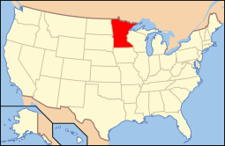
Location of Adair County in Missouri
This is a list of the National Register of Historic Places listings in Adair County, Missouri.
This is intended to be a complete list of the properties and districts on the National Register of Historic Places in Adair County, Missouri, United States. Latitude and longitude coordinates are provided for many National Register properties and districts; these locations may be seen together in a map.[1]
There are 17 properties and districts listed on the National Register in the county.
- This National Park Service list is complete through NPS recent listings posted December 16, 2016.[2]
Current listings
| [3] |
Name on the Register |
Image |
Date listed[4] |
Location |
City or town |
Description |
|---|
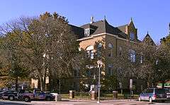
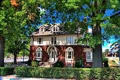
| 1 |
Adair County Courthouse |
|
000000001978-08-11-0000August 11, 1978
(#78001636) |
Washington St.
40°11′42″N 92°35′01″W / 40.195°N 92.583611°W / 40.195; -92.583611 (Adair County Courthouse) |
Kirksville |
|
| 2 |
Bear Creek Baptist Church |
|
000000001984-03-29-0000March 29, 1984
(#84002132) |
N of Kirksville off US 63
40°14′30″N 92°37′31″W / 40.241667°N 92.625278°W / 40.241667; -92.625278 (Bear Creek Baptist Church) |
Kirksville |
|
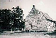
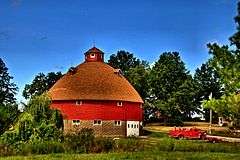
| 3 |
Cabins Historic District |
|
000000001979-07-17-0000July 17, 1979
(#79001344) |
S of Novinger off MO 6
40°12′31″N 92°41′10″W / 40.208611°N 92.686111°W / 40.208611; -92.686111 (Cabins Historic District) |
Novinger |
|
| 4 |
Dockery Hotel |
Upload image |
000000001983-02-10-0000February 10, 1983
(#83000971) |
Elson and McPherson Sts.
40°11′38″N 92°35′04″W / 40.193889°N 92.584444°W / 40.193889; -92.584444 (Dockery Hotel) |
Kirksville |
Demolished in 1991.[5]
|
| 5 |
Grim Building |
|
000000001979-06-27-0000June 27, 1979
(#79001343) |
113-115 E. Washington St.
40°11′43″N 92°34′52″W / 40.195278°N 92.581111°W / 40.195278; -92.581111 (Grim Building) |
Kirksville |
|
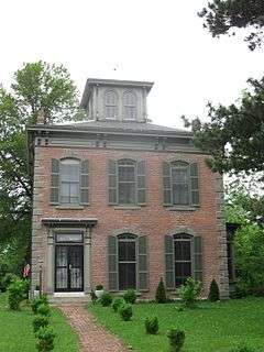
| 6 |
Capt. Thomas C. Harris House |
|
000000001973-10-15-0000October 15, 1973
(#73001034) |
1308 N. Franklin St.
40°12′19″N 92°34′56″W / 40.205278°N 92.582222°W / 40.205278; -92.582222 (Capt. Thomas C. Harris House) |
Kirksville |
|
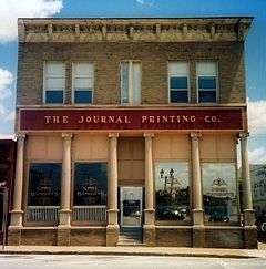
| 7 |
Journal Printing Company Building |
|
000000002011-07-14-0000July 14, 2011
(#11000439) |
119 S. Elson St.
40°11′40″N 92°35′03″W / 40.194444°N 92.584167°W / 40.194444; -92.584167 (Journal Printing Company Building) |
Kirksville |
|
| 8 |
Kirksville Courthouse Square Historic District |
|
000000002009-05-21-0000May 21, 2009
(#09000330) |
200 block N. Franklin St., 100 block E. Harrison St., 100 block W. Harrison St.
40°11′44″N 92°34′59″W / 40.195564°N 92.583142°W / 40.195564; -92.583142 (Kirksville Courthouse Square Historic District) |
Kirksville |
|
| 9 |
Drs. George and Blanche Laughlin House |
Upload image |
000000002014-03-11-0000March 11, 2014
(#14000047) |
706 S. Halliburton St.
40°11′22″N 92°34′37″W / 40.189492°N 92.577049°W / 40.189492; -92.577049 (Drs. George and Blanche Laughlin House) |
Kirksville |
|
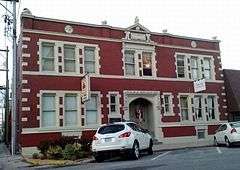
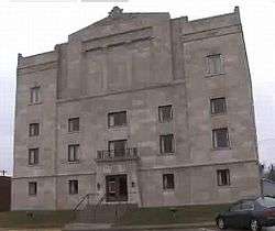
| 10 |
Masonic Temple |
|
000000002010-01-07-0000January 7, 2010
(#09001208) |
217 E. Harrison St.
40°11′44″N 92°34′55″W / 40.195572°N 92.581883°W / 40.195572; -92.581883 (Masonic Temple) |
Kirksville |
Egyptian Revival architecture[6]
|
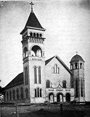
| 11 |
St. Mary's Church |
|
000000001974-12-16-0000December 16, 1974
(#74001069) |
On MO 11
40°15′08″N 92°22′27″W / 40.252222°N 92.374167°W / 40.252222; -92.374167 (St. Mary's Church) |
Adair |
Romanesque Revival architecture.
|
| 12 |
Dr. E. Sanborn Smith House |
|
000000002009-01-30-0000January 30, 2009
(#08001385) |
111 E. Patterson St.
40°11′11″N 92°34′59″W / 40.186375°N 92.583°W / 40.186375; -92.583 (Dr. E. Sanborn Smith House) |
Kirksville |
|
| 13 |
Orie J. Smith Black and White Stock Farm Historic District |
|
000000002001-01-16-0000January 16, 2001
(#00001658) |
0.5 miles SE of Jct. of MO P and Co. Rd. 129B
40°13′32″N 92°33′33″W / 40.225556°N 92.559167°W / 40.225556; -92.559167 (Orie J. Smith Black and White Stock Farm Historic District) |
Kirksville |
|
| 14 |
Sojourners Club |
Upload image |
000000002014-03-11-0000March 11, 2014
(#14000048) |
211 S. Elson St.
40°11′36″N 92°35′03″W / 40.193359°N 92.58403°W / 40.193359; -92.58403 (Sojourners Club) |
Kirksville |
|
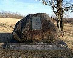
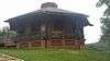
| 15 |
Thousand Hills State Park Petroglyphs Archeological Site |
|
000000001970-01-23-0000January 23, 1970
(#70000320) |
W of Kirksville
40°11′12″N 92°38′28″W / 40.186667°N 92.641111°W / 40.186667; -92.641111 (Thousand Hills State Park Petroglyphs Archeological Site) |
Kirksville |
Within Thousand Hills State Park
|
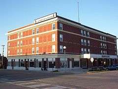
| 16 |
Travelers Hotel |
|
000000002009-09-16-0000September 16, 2009
(#09000718) |
301 W. Washington St.
40°11′41″N 92°35′07″W / 40.194678°N 92.58535°W / 40.194678; -92.58535 (Travelers Hotel) |
Kirksville |
|
| 17 |
Trinity Episcopal Church |
|
000000002008-01-02-0000January 2, 2008
(#07001338) |
124 N Mulanix St.
40°11′50″N 92°34′47″W / 40.197222°N 92.579722°W / 40.197222; -92.579722 (Trinity Episcopal Church) |
Kirksville |
|
See also
References
- ↑ The latitude and longitude information provided in this table was derived originally from the National Register Information System, which has been found to be fairly accurate for about 99% of listings. For about 1% of NRIS original coordinates, experience has shown that one or both coordinates are typos or otherwise extremely far off; some corrections may have been made. A more subtle problem causes many locations to be off by up to 150 yards, depending on location in the country: most NRIS coordinates were derived from tracing out latitude and longitudes off of USGS topographical quadrant maps created under the North American Datum of 1927, which differs from the current, highly accurate WGS84 GPS system used by most on-line maps. Chicago is about right, but NRIS longitudes in Washington are higher by about 4.5 seconds, and are lower by about 2.0 seconds in Maine. Latitudes differ by about 1.0 second in Florida. Some locations in this table may have been corrected to current GPS standards.
- ↑ "National Register of Historic Places: Weekly List Actions". National Park Service, United States Department of the Interior. Retrieved on December 16, 2016.
- ↑ Numbers represent an ordering by significant words. Various colorings, defined here, differentiate National Historic Landmarks and historic districts from other NRHP buildings, structures, sites or objects.
- ↑ The eight-digit number below each date is the number assigned to each location in the National Register Information System database, which can be viewed by clicking the number.
- ↑ http://www.dnr.mo.gov/shpo/Adair.htm
- ↑ Eden Derby, Historic Places: Inside the Masonic Temple, KTVO TV-3, May 13, 2010
|
|---|
|
| Topics | |
|---|
|
| Lists by states | |
|---|
|
| Lists by insular areas | |
|---|
|
| Lists by associated states | |
|---|
|
| Other areas | |
|---|
|
-
 Portal Portal
-
 WikiProject WikiProject
|
|
|---|
|
Lists
by county | | |
|---|
|
| Other lists | |
|---|
|
|