National Register of Historic Places listings in Jefferson County, Missouri

Location of Jefferson County in Missouri
This is a list of the National Register of Historic Places listings in Jefferson County, Missouri.
This is intended to be a complete list of the properties and districts on the National Register of Historic Places in Jefferson County, Missouri, United States. Latitude and longitude coordinates are provided for many National Register properties and districts; these locations may be seen together in a map.[1]
There are 14 properties and districts listed on the National Register in the county.
- This National Park Service list is complete through NPS recent listings posted December 16, 2016.[2]
Current listings
| [3] | Name on the Register | Image | Date listed[4] | Location | City or town | Description |
|---|---|---|---|---|---|---|
| 1 | Beaumont-Tyson Quarry District | Upload image | (#74001079) |
Address Restricted |
Times Beach | |
| 2 | Boemler Archeological District | Upload image | (#74001075) |
Address Restricted |
Byrnes Mill | |
| 3 | Boland Archeological District | Upload image | (#74001080) |
Address Restricted |
Times Beach | |
| 4 | Central School Campus | Upload image | (#09000813) |
221 S. 3rd St. 38°08′18″N 90°33′23″W / 38.138292°N 90.556497°W |
De Soto | |
| 5 | Thomas C. Fletcher House | Upload image | (#74001076) |
Elm between 1st and 2nd Sts. 38°13′55″N 90°34′02″W / 38.231944°N 90.567222°W |
Hillsboro | |
| 6 | Gustave Greystone-Meissner House | Upload image | (#74001078) |
Northeast of Pevely off U.S. Route 61 38°18′13″N 90°22′48″W / 38.303611°N 90.38°W |
Pevely | |
| 7 | Kimmswick Bone Bed | 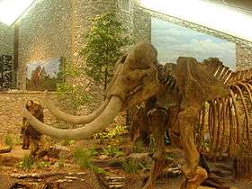 |
(#80002371) |
Junction of Rock and Little Rock Creeks[5]:41 38°22′45″N 90°23′01″W / 38.379167°N 90.383611°W |
Imperial | Also known as "Mastodon State Historic Site". |
| 8 | Kimmswick Historic District | Upload image | (#07000752) |
Roughly bounded by Front St., 4th St., Mill St., Elm St., and Oak St. 38°22′00″N 90°21′51″W / 38.366606°N 90.364153°W |
Kimmswick | |
| 9 | Valentine Leight General Store | 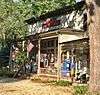 |
(#92001014) |
4566 Main St. 38°24′37″N 90°34′09″W / 38.410278°N 90.569167°W |
House Springs | |
| 10 | Moder Archeological District | Upload image | (#74001077) |
Address Restricted |
House Springs | |
| 11 | Louis J. and Harriet Rozier House | Upload image | (#06000221) |
322 W. Clement 38°08′16″N 90°33′27″W / 38.137778°N 90.5575°W |
DeSoto | |
| 12 | Sandy Creek Covered Bridge | 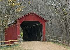 |
(#70000337) |
5 miles north of Hillsboro off U.S. Route 21 38°17′38″N 90°31′05″W / 38.293889°N 90.518056°W |
Hillsboro | |
| 13 | Stonebrook | Upload image | (#10001130) |
3511 Stonebrook Forest Dr. 38°21′38″N 90°27′44″W / 38.360556°N 90.462222°W |
Antonia | |
| 14 | Windsor Harbor Road Bridge | |
(#83001024) |
Windsor Harbor Rd. at Rock Creek 38°21′50″N 90°21′44″W / 38.363889°N 90.362222°W |
Kimmswick |
See also
- List of National Historic Landmarks in Missouri
- National Register of Historic Places listings in Missouri
References
| Wikimedia Commons has media related to National Register of Historic Places in Jefferson County, Missouri. |
- ↑ The latitude and longitude information provided in this table was derived originally from the National Register Information System, which has been found to be fairly accurate for about 99% of listings. For about 1% of NRIS original coordinates, experience has shown that one or both coordinates are typos or otherwise extremely far off; some corrections may have been made. A more subtle problem causes many locations to be off by up to 150 yards, depending on location in the country: most NRIS coordinates were derived from tracing out latitude and longitudes off of USGS topographical quadrant maps created under the North American Datum of 1927, which differs from the current, highly accurate WGS84 GPS system used by most on-line maps. Chicago is about right, but NRIS longitudes in Washington are higher by about 4.5 seconds, and are lower by about 2.0 seconds in Maine. Latitudes differ by about 1.0 second in Florida. Some locations in this table may have been corrected to current GPS standards.
- ↑ "National Register of Historic Places: Weekly List Actions". National Park Service, United States Department of the Interior. Retrieved on December 16, 2016.
- ↑ Numbers represent an ordering by significant words. Various colorings, defined here, differentiate National Historic Landmarks and historic districts from other NRHP buildings, structures, sites or objects.
- ↑ The eight-digit number below each date is the number assigned to each location in the National Register Information System database, which can be viewed by clicking the number.
- ↑ Adams, Robert McCormick. "The Kimmswick Bone Bed". Missouri Archaeologist 15.4 (1953): 40-56.
| Topics | |
|---|---|
| Lists by states |
|
| Lists by insular areas | |
| Lists by associated states | |
| Other areas | |
| |
Municipalities and communities of Jefferson County, Missouri, United States | ||
|---|---|---|
| Cities | | |
| Villages | ||
| Townships | ||
| CDPs |
| |
| Unincorporated communities | ||
This article is issued from Wikipedia - version of the 6/19/2016. The text is available under the Creative Commons Attribution/Share Alike but additional terms may apply for the media files.