National Register of Historic Places listings in Mississippi County, Missouri
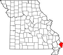
Location of Mississippi County in Missouri
This is a list of the National Register of Historic Places listings in Mississippi County, Missouri.
This is intended to be a complete list of the properties and districts on the National Register of Historic Places in Mississippi County, Missouri, United States. Latitude and longitude coordinates are provided for many National Register properties and districts; these locations may be seen together in a map.[1]
There are 10 properties and districts listed on the National Register in the county.
- This National Park Service list is complete through NPS recent listings posted December 16, 2016.[2]
Current listings
| [3] | Name on the Register | Image | Date listed[4] | Location | City or town | Description |
|---|---|---|---|---|---|---|
| 1 | Beckwith's Fort Archeological Site | 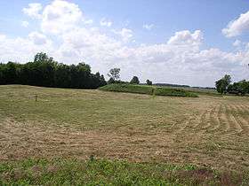 |
(#69000113) |
County Road 502[5] 36°41′36″N 89°14′08″W / 36.693333°N 89.235556°W |
Wolf Island | Also known as Towosahgy State Historic Site[6] |
| 2 | Crosno Fortified Village Archeological Site | Upload image | (#69000112) |
Southeastern quarter of Section 23, Township 25 North, Range 17 East[7]:231 36°47′41″N 89°10′51″W / 36.794722°N 89.180833°W |
Crosno | |
| 3 | Hearnes Site |  |
(#73001047) |
U.S. Route 60 east of Charleston, immediately west of the Charleston Country Club[8] 36°55′23″N 89°18′12″W / 36.923056°N 89.303333°W |
Charleston | |
| 4 | Hess Archeological Site | Upload image | (#74001081) |
Midway between Pinhook and Towosahgy State Historic Site, east of Missouri Route F1[7]:235 36°43′08″N 89°15′04″W / 36.718889°N 89.251111°W |
East Prairie | |
| 5 | Hoecake Village Archeological Site | Upload image | (#72000723) |
2.5 miles (4.0 km) west of Pinhook[9] 36°44′20″N 89°18′46″W / 36.738889°N 89.312778°W |
East Prairie | Smithsonian trinomial 23MI8[9] |
| 6 | Missouri Pacific Depot | 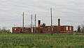 |
(#72000722) |
East of intersecting branches of the Missouri Pacific Railroad 36°55′22″N 89°21′28″W / 36.922778°N 89.357778°W |
Charleston | |
| 7 | Moore House |  |
(#80002380) |
403 N. Main St. 36°55′35″N 89°21′02″W / 36.926389°N 89.350556°W |
Charleston | |
| 8 | Mueller Archeological Site | Upload image | (#74001082) |
Address Restricted |
East Prairie | |
| 9 | O'Bryan Ridge Archeological District | Upload image | (#72000724) |
Missouri Route 77 south of Wyatt[10] 36°52′02″N 89°12′54″W / 36.867222°N 89.215000°W |
Wyatt | |
| 10 | Jacob Swank House |  |
(#73001048) |
0.2 miles west of Charleston on U.S. Routes 60 and 62 36°55′20″N 89°22′16″W / 36.922222°N 89.371000°W |
Charleston |
See also
- List of National Historic Landmarks in Missouri
- National Register of Historic Places listings in Missouri
References
| Wikimedia Commons has media related to National Register of Historic Places in Mississippi County, Missouri. |
- ↑ The latitude and longitude information provided in this table was derived originally from the National Register Information System, which has been found to be fairly accurate for about 99% of listings. For about 1% of NRIS original coordinates, experience has shown that one or both coordinates are typos or otherwise extremely far off; some corrections may have been made. A more subtle problem causes many locations to be off by up to 150 yards, depending on location in the country: most NRIS coordinates were derived from tracing out latitude and longitudes off of USGS topographical quadrant maps created under the North American Datum of 1927, which differs from the current, highly accurate WGS84 GPS system used by most on-line maps. Chicago is about right, but NRIS longitudes in Washington are higher by about 4.5 seconds, and are lower by about 2.0 seconds in Maine. Latitudes differ by about 1.0 second in Florida. Some locations in this table may have been corrected to current GPS standards.
- ↑ "National Register of Historic Places: Weekly List Actions". National Park Service, United States Department of the Interior. Retrieved on December 16, 2016.
- ↑ Numbers represent an ordering by significant words. Various colorings, defined here, differentiate National Historic Landmarks and historic districts from other NRHP buildings, structures, sites or objects.
- ↑ The eight-digit number below each date is the number assigned to each location in the National Register Information System database, which can be viewed by clicking the number.
- ↑ Towosahgy State Historic Site, Missouri Department of Natural Resources, n.d. Accessed 2012-11-27.
- ↑ National Park Service (2010-07-09). "National Register Information System". National Register of Historic Places. National Park Service.
- 1 2 Chapman, Carl, et al. "Investigation and Comparison of Two Fortified Mississippian Traditional Archaeological Sites in Southeastern Missouri: A Preliminary Compilation". Missouri Archaeologist 38 Whole Volume (1977).
- ↑ Klippel, Walter Emerson. "The Hearnes Site: A Multicomponent Occupation Site and Cemetery in the Cairo Lowland Region of Southeast Missouri". Missouri Archaeologist 31 (1969): whole volume: 13.
- 1 2 Emerson, Thomas E., and R. Barry Lewis. Cahokia and the Hinterlands: Middle Mississippian Cultures of the Midwest. Champaign: U of Illinois P, 2000, 277-278.
- ↑ O'Brien, Michael J., and Robert C. Dunnell, eds. Changing Perspectives on the Archaeology of the Central Mississippi Valley. Tuscaloosa and London: U of Alabama P, 1998, 137.
| Topics | |
|---|---|
| Lists by states |
|
| Lists by insular areas | |
| Lists by associated states | |
| Other areas | |
| |
Municipalities and communities of Mississippi County, Missouri, United States | ||
|---|---|---|
| Cities | | |
| Villages | ||
| Townships |
| |
| Unincorporated communities | ||
| Ghost towns | ||
| Footnotes | ‡This populated place also has portions in an adjacent county or counties | |
This article is issued from Wikipedia - version of the 10/12/2016. The text is available under the Creative Commons Attribution/Share Alike but additional terms may apply for the media files.