Ohio State Route 19
| |||||||
|---|---|---|---|---|---|---|---|
 | |||||||
| Route information | |||||||
| Maintained by ODOT | |||||||
| Length: | 86.48 mi[1] (139.18 km) | ||||||
| Existed: | 1932 – present | ||||||
| Major junctions | |||||||
| South end: |
| ||||||
|
| |||||||
| North end: |
| ||||||
| Location | |||||||
| Counties: | Morrow, Crawford, Seneca, Sandusky, Ottawa | ||||||
| Highway system | |||||||
| |||||||


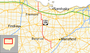
State Route 19 (SR 19) is a north–south route in northern and central Ohio. Its southern terminus is at U.S. Route 42 in the unincorporated village of Williamsport, and its northern terminus is at State Route 2 north of Oak Harbor.
History
The current State Route 19 was certified in 1932 and originally went from Galion to Oak Harbor, going through Fremont on State Street (U.S. Route 20) and Stone Street. The route was extended in the north to State Route 2 in 1938, and in the south to U.S. Route 42 in 1939. In 1960, State Route 19 was rerouted around Fremont along with U.S. Route 20, U.S. Route 6, and State Route 53 (Ohio) via a freeway bypass.
The route number 19 was used for the route of an original state highway that went from Columbus to the Pennsylvania state line. This route is now the eastern Ohio portion of U.S. Route 62. The route number was then given to the route of the former State Route 62, which the U.S. highway system had made defunct.
Major intersections
| County | Location | mi[1] | km | Exit | Destinations | Notes |
|---|---|---|---|---|---|---|
| Morrow | Congress Township | 0.00 | 0.00 | |||
| North Bloomfield Township | 8.78 | 14.13 | ||||
| Crawford | Galion | 11.90 | 19.15 | Southern end of SR 97 concurrency | ||
| 12.60 | 20.28 | Northern end of SR 97 concurrency; southern end of SR 61 / SR 309 concurrency | ||||
| 13.87 | 22.32 | Northern end of SR 61 / SR 309 concurrency; southern terminus of SR 598 | ||||
| Polk–Whetstone township line | 17.05 | 27.44 | Southern terminus of SR 602 | |||
| Whetstone Township | 21.51 | 34.62 | Southern end of SR 100 concurrency | |||
| Bucyrus | 24.92 | 40.10 | Southern end of SR 4 / SR 98 concurrency | |||
| 25.12 | 40.43 | Northern end of SR 98 concurrency | ||||
| 25.92 | 41.71 | Interchange | ||||
| 26.48 | 42.62 | Northern end of SR 4 concurrency | ||||
| Lykens Township | 33.68 | 54.20 | Northern end of SR 100 concurrency | |||
| 35.69 | 57.44 | |||||
| Seneca | Bloom–Scipio township line | 44.75 | 72.02 | |||
| Republic | 47.75 | 76.85 | ||||
| 47.86 | 77.02 | Northern terminus of SR 67 | ||||
| Adams Township | 53.86 | 86.68 | Southern terminus of SR 228 | |||
| 55.49 | 89.30 | |||||
| 55.89 | 89.95 | Northern terminus of SR 778 | ||||
| Sandusky | Green Creek Township | 64.23 | 103.37 | Southern end of US 20 concurrency | ||
| 64.53– 64.70 | 103.85– 104.12 | 105 | State Street – Fremont | Interchange; northbound exit / southbound entrance only | ||
| Sandusky Township | 66.52 | 107.05 | 103 | Interchange; western terminus of SR 412 | ||
| Fremont | 67.47 | 108.58 | 102 | Interchange; southern end of US 6 concurrency | ||
| 68.88 | 110.85 | 101 | Interchange; southern end of SR 53 concurrency | |||
| 69.64 | 112.07 | 100 | Interchange; northern end of US 6 / US 20 / SR 53 concurrency | |||
| Rice Township | 74.93 | 120.59 | Western terminus of SR 523 | |||
| Ottawa | Oak Harbor | 79.85 | 128.51 | Eastern terminus of SR 105 | ||
| Carroll Township | 86.48 | 139.18 | ||||
1.000 mi = 1.609 km; 1.000 km = 0.621 mi
| ||||||