Summerland, British Columbia
| Summerland | ||
|---|---|---|
| District municipality | ||
| The Corporation of the District of Summerland[1] | ||
|
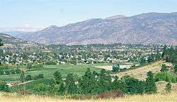
A view of Summerland | ||
| ||
| Nickname(s): Town of Festivals | ||
 Summerland Location of Summerland in British Columbia | ||
| Coordinates: 49°36′02″N 119°40′40″W / 49.60056°N 119.67778°W | ||
| Country |
| |
| Province |
| |
| Region | South Okanagan | |
| Regional District | Okanagan-Similkameen | |
| Founded | 1902 | |
| Government | ||
| • Mayor | Peter Waterman | |
| Area | ||
| • Total | 73.88 km2 (28.53 sq mi) | |
| Elevation | 454 m (1,490 ft) | |
| Population (2011) | ||
| • Total | 11,280 | |
| • Density | 150/km2 (400/sq mi) | |
| Postal code | V0H | |
| Area code(s) | +250 | |
| Website | summerland.ca | |
.JPG)
| Historical population | ||
|---|---|---|
| Year | Pop. | ±% |
| 1921 | 1,892 | — |
| 1931 | 1,791 | −5.3% |
| 1941 | 2,054 | +14.7% |
| 1951 | 3,567 | +73.7% |
| 1956 | 3,893 | +9.1% |
| 1961 | 4,307 | +10.6% |
| 1966 | 4,585 | +6.5% |
| 1971 | 5,551 | +21.1% |
| 1976 | 6,724 | +21.1% |
| 1981 | 7,473 | +11.1% |
| 1986 | 7,755 | +3.8% |
| 1991 | 9,253 | +19.3% |
| 1996 | 10,584 | +14.4% |
| 2001 | 10,713 | +1.2% |
| 2006 | 10,828 | +1.1% |
| 2011 | 11,280 | +4.2% |
| Sources: Statistics Canada[2] | ||
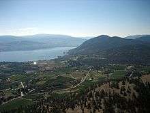
Summerland (2011 population 11,280) is a town on the west side of Okanagan Lake in the interior of British Columbia, Canada. The district is between Peachland to the north and Penticton to the south. The largest centre in the region is Kelowna, approximately 50 km to the north (via Highway 97), and Vancouver is approximately 425 km (264 mi) away to the west. The district is famous for "Bottleneck drive", a system of roads connecting a large number of wineries.
Electoral representatives
The current Mayor is Peter Waterman. The district's (2016 federal) Member of Parliament is Dan Albas. Its (provincial) Member of Legislative Assembly is Liberal cabinet minister; Dan Ashton.
History
In 2006, the District of Summerland celebrated its centennial as an incorporated municipality in 1906, yet the history of settlement in the Summerland area extends beyond that time. Summerland's first inhabitants were the Okanagan Salish with the Nation's boundaries extending from Kamloops to southern Washington State. The area known as "Nicola Prairie" was notably named after the Grand Chief Nicola.
A published map of the Okanagan Valley in 1827 includes only three sites for the entire Okanagan Valley; Nicola Prairie; Lone Tree (north end of Summerland); and Sandy Cove (across the lake from present day Kelowna). Summerland's proud and diverse past includes hunting and fur trading, ranching, orchards and fruit industries, transportation hubs and more recently, tourism. Immigration to the Summerland area commenced in the late 1880s when the first settlers arrived and began diverting water to irrigate orchards. The first commercial orchard was planted in the 1890s in Trout Creek, where a water license was issued to irrigate 1,000 acres.
The first settlement identified on maps of the Okanagan Valley was Priest Encampment located on the shores of Garnett Lake. Later development began on the shores of Okanagan Lake. The upper benches continued to be an important transportation route and a number of small communities were constructed or were planned for development. They included Upper Trout Creek, Balcomo, the Prairie Valley Townsite, Mineola and Appledale. In 1892 Upper Trout Creek was established.
Summerland's former name was Trout Creek. In the 1890s George Barclay operated the largest cattle ranch in Trout Creek. In 1902 Sir Thomas Shaughnessy bought the Barclay Ranch and formed Summerland; incorporation was not completed until 1906. By the 1920s the present location of downtown Summerland was developed and the earlier areas on the upper benches were not utilized or forgotten. Downtown Summerland (Siwash Flat) was originally part of the Penticton Indian Reserve No. 3 (exchanged between 1904-06 following a mutually agreeable land deal). The subject lands eventually became known as West Summerland.
Present day Lower Town was the original town site of Summerland. In the early 1900s the Summerland Development Company with Sir Thomas Shaughnessy (President) and J.M. Robinson (Manager) primarily responsible for the initial decisions on its development. From the Company, the community received water, septic tanks, electricity, a post office, a school and a sawmill. Settlers from across the prairies, eastern Canada and England were drawn to the Summerland area.
By 1907, Summerland had access to Peachland and Penticton with a well-established road system, and a ferry service connecting the community with the eastern shore of Okanagan Lake (Naramata). West Summerland (present day Downtown Summerland) experienced increased importance also in part due to a 1922 fire which destroyed many of the lakeside buildings in Lower Town.[3]
Geography
Summerland is located within the Thompson-Okanagan Plateau ecoregion. This is one of the warmest and driest ecoregions in Canada. It is characterized by rolling plateaus and major valley systems of the Okanagan, Thompson and Nicola rivers. The mean annual temperature of the major valleys is approximately 10 °C with a summer mean of 21 °C and a winter mean of -3.5 °C; however, winter months are often very temperate and cold weather usually lasts no more than a few weeks, while summer months often see drought with high daytime and cool nighttime temperatures. In the summer of 2003, a severe drought nearly rendered the town's reservoir incapable of ensuring a water supply through to the beginning of the next annual replenishment cycle. Since then, awareness of the real need for water conservation measures has begun to be taken seriously, and permanent water use restrictions are now in place.
The immediate ecosystem consists of grasslands in a matrix of bluebunch wheat grass and sagebrush amongst scattered Ponderosa pines. The region has a gently rolling surface covered mainly by glacial deposits. Summerland is home to an extinct volcano, known locally as Giant's Head Mountain - so-named for its gigantic facial profile as viewed from the southeast. This "hill" dominates the town's land features and provides an hour's hike to the top for an expansive view up and down the Okanagan Valley.
The range of representative wildlife around Summerland includes mule deer, Canada geese, California quail, ravens, coyotes, red wolves (half coyote, half wolf), blue grouse, bald eagles, and black widow spiders. Back into the hills surrounding Summerland is natural habitat for black bear, white-tailed deer, moose, cougars and bobcats, California big-horn sheep, mountain goats, and rattlesnakes.
Demographics
| Canada 2006 Census | Population | % of Total Population | |
|---|---|---|---|
| Visible minority group Source:[4] | Chinese | 65 | 0.6% |
| South Asian | 145 | 1.4% | |
| Black | 45 | 0.4% | |
| Filipino | 10 | 0.1% | |
| Latin American | 10 | 0.1% | |
| Southeast Asian | 0 | 0% | |
| Arab | 0 | 0% | |
| West Asian | 10 | 0.1% | |
| Korean | 30 | 0.3% | |
| Japanese | 55 | 0.5% | |
| Other visible minority | 10 | 0.1% | |
| Mixed visible minority | 0 | 0% | |
| Total visible minority population | 375 | 3.5% | |
| Aboriginal group Source:[5] | First Nations | 290 | 2.7% |
| Métis | 1 | 0.01% | |
| Inuit | 0 | 0% | |
| Total Aboriginal population | 290 | 2.7% | |
| White | 10,020 | 93.8% | |
| Total population | 10,686 | 100% | |
Education
Summerland's public school system is operated by School District 67 Okanagan Skaha which operates two elementary schools (Giants Head and Trout Creek), one middle school (Summerland Middle), and one secondary school (Summerland Secondary). Summerland has one private school (a Montessori school), after The Glenfir School shut down in March 2011.[6]
Tourism
Summerland is popular because of its idyllic situation on Okanagan Lake and sandy beaches, a playground for three major Canadian population centres (Vancouver, Calgary, Edmonton). Both tourism and tourist attractions are a significant industry. Agriculture, featuring fresh tree fruits (peaches, cherries, apricots, apples and pears), and canneries, were the economic engine of the region until the late 20th Century. Stone fruit and apples are now produced mainly for the fresh market (local and export). Over the past 20 years, Summerland has become home to several world-renowned wineries, and despite being in an arid desert climate, has several golf courses. Summerland is also home to the historic Kettle Valley Steam Railway. The railway runs constantly, taking tourists on a trip around the Dale Meadows region of Summerland and further, eventually ending at the famous Trout Creek Trestle. Tourism Summerland guides visitors to Summerland attractions and events.
Wine
Summerland is home to one of Canada's largest wine industries. Many of Summerland's wineries are connected by the famed 'Bottleneck Drive.' Famed wineries include Thornhaven, Dirty Laundry, Sleeping Giant, Sonoran, Summer Gate, Sumac Ridge, the Tethered Lamb, Vinegar Works, Hollywood Wine, Heaven's Gate, SilkScarf, 8th Generation and Bonitas.
Sport
Summerland is the home of the Summerland Steam of the Kootenay International Junior Hockey League. The town also used to be the home of the Summerland Sting (2001-2009), and the Summerland Warriors (1999-2000), both of whom played in the same league. Previously the Summerland Buckaroos played in the British Columbia Hockey League from 1983-1988. Summerland is also home to the Summerland Minor Hockey Association (SMHA) known as the Summerland Jets.
Worship
- Summerland Baptist Church
- St. John's Lutheran Church
- Julia Street Community Church
- Kingdom Hall of Jehovah's Witnesses
- Summerland Alliance Church
- Holy Child Catholic Church
- Saint Stephen's Anglican Church
- South Okanagan Hindu Temple
Climate
Summerland has a humid continental climate with hot, dry summers and cool winters. Late fall and most of the winter see very little sunshine in Summerland, but Summerland gets more days with sunshine during the spring than any other place in Canada. The sun makes an appearance on average of 88.4 days each spring.
Because Summerland is located up on a natural bench, it stays relatively warm at night. By comparison, Penticton experiences colder nights as the cool air sinks down into the valley below. These warm nights in a dry climate means that Summerland has the lowest morning relative humidity in Canada from May through September.[7]
| Climate data for Summerland | |||||||||||||
|---|---|---|---|---|---|---|---|---|---|---|---|---|---|
| Month | Jan | Feb | Mar | Apr | May | Jun | Jul | Aug | Sep | Oct | Nov | Dec | Year |
| Record high °C (°F) | 15.5 (59.9) |
16.7 (62.1) |
22.2 (72) |
28.9 (84) |
33.9 (93) |
38.3 (100.9) |
40.0 (104) |
37.8 (100) |
36.0 (96.8) |
28.5 (83.3) |
19.5 (67.1) |
15.6 (60.1) |
40.0 (104) |
| Average high °C (°F) | 1.2 (34.2) |
3.7 (38.7) |
10.0 (50) |
14.7 (58.5) |
19.9 (67.8) |
23.7 (74.7) |
26.8 (80.2) |
26.8 (80.2) |
21.0 (69.8) |
13.3 (55.9) |
5.3 (41.5) |
0.2 (32.4) |
13.9 (57) |
| Daily mean °C (°F) | −1.3 (29.7) |
0.4 (32.7) |
5.2 (41.4) |
9.3 (48.7) |
13.9 (57) |
17.6 (63.7) |
20.3 (68.5) |
20.3 (68.5) |
15.1 (59.2) |
8.8 (47.8) |
2.4 (36.3) |
−2.3 (27.9) |
9.1 (48.4) |
| Average low °C (°F) | −3.8 (25.2) |
−2.9 (26.8) |
0.4 (32.7) |
3.7 (38.7) |
7.8 (46) |
11.5 (52.7) |
13.8 (56.8) |
13.7 (56.7) |
9.1 (48.4) |
4.3 (39.7) |
−0.5 (31.1) |
−4.7 (23.5) |
4.4 (39.9) |
| Record low °C (°F) | −30.0 (−22) |
−26.7 (−16.1) |
−21.7 (−7.1) |
−8.9 (16) |
−5.0 (23) |
1.5 (34.7) |
4.4 (39.9) |
5.6 (42.1) |
−3.9 (25) |
−14.0 (6.8) |
−23.0 (−9.4) |
−29.4 (−20.9) |
−30.0 (−22) |
| Average precipitation mm (inches) | 25.6 (1.008) |
18.5 (0.728) |
20.7 (0.815) |
28.8 (1.134) |
37.1 (1.461) |
42.2 (1.661) |
36.1 (1.421) |
30.2 (1.189) |
20.1 (0.791) |
19.5 (0.768) |
28.0 (1.102) |
30.0 (1.181) |
336.7 (13.256) |
| Average rainfall mm (inches) | 10.2 (0.402) |
12.5 (0.492) |
19.1 (0.752) |
28.8 (1.134) |
37.1 (1.461) |
42.2 (1.661) |
36.1 (1.421) |
30.2 (1.189) |
20.1 (0.791) |
19.2 (0.756) |
21.5 (0.846) |
10.1 (0.398) |
287.0 (11.299) |
| Average snowfall cm (inches) | 16.1 (6.34) |
7.7 (3.03) |
2.3 (0.91) |
0.0 (0) |
0.0 (0) |
0.0 (0) |
0.0 (0) |
0.0 (0) |
0.0 (0) |
0.2 (0.08) |
6.7 (2.64) |
21.0 (8.27) |
54.0 (21.26) |
| Average precipitation days (≥ 0.2 mm) | 10.3 | 9.3 | 9.1 | 11.2 | 11.5 | 11.2 | 9.7 | 8.6 | 5.9 | 7.3 | 12.6 | 12.1 | 118.8 |
| Average rainy days (≥ 0.2 mm) | 5.1 | 6.3 | 8.6 | 11.2 | 11.5 | 11.2 | 9.7 | 8.6 | 5.9 | 7.2 | 10.8 | 4.6 | 100.8 |
| Average snowy days (≥ 0.2 cm) | 5.8 | 3.3 | 0.9 | 0.0 | 0.0 | 0.0 | 0.0 | 0.0 | 0.0 | 0.1 | 2.5 | 8.1 | 20.7 |
| Mean monthly sunshine hours | 40.8 | 93.9 | 160.0 | 195.2 | 248.1 | 256.3 | 302.2 | 283.2 | 223.2 | 148.9 | 64.2 | 42.0 | 2,057.9 |
| Percent possible sunshine | 15.2 | 33.1 | 43.5 | 47.4 | 52.2 | 52.7 | 61.6 | 63.3 | 58.8 | 44.4 | 23.4 | 16.5 | 42.7 |
| Source: [7] | |||||||||||||
International relations
Summerland serves as a sister city with Omak, Washington, a city in the United States,[8] and Toyokoro, Hokkaido, a town in Japan.[9]
Notable people
- Nicole Dunsdon - Miss Canada 1992
- Cynthia Kereluk - Miss Canada 1984
- Justin Kripps - Bobsleigh
- Kristi Richards - Freestyle skier
- Deven Sideroff - ice hockey player, selected in 3rd round of 2015 NHL Entry Draft by the Anaheim Ducks
- Dan O'Rourke - NHL referee
References
- ↑ "British Columbia Regional Districts, Municipalities, Corporate Name, Date of Incorporation and Postal Address" (XLS). British Columbia Ministry of Communities, Sport and Cultural Development. Retrieved 2 November 2014.
- ↑ "Historical Municipal Census Data: 1921–2011". BC Stats. Retrieved 25 August 2013.
- ↑ "Official Community Plan".
- ↑ "Community Profiles from the 2006 Census, Statistics Canada - Census Subdivision". 2.statcan.gc.ca. 2010-12-06. Retrieved 2013-04-13.
- ↑ "Aboriginal Peoples - Data table". 2.statcan.ca. 2010-10-06. Retrieved 2013-04-13.
- ↑ Kidd, Steve. "Final Bell Sounds for Summerland's Glenfir School". Penticton Western. Retrieved 4 November 2011.
- 1 2 "Environment Canada Climate Normals". Environment Canada. Retrieved 27 Oct 2014.
- ↑ "Washington's 'Sister' Relationships". Lieutenant Governor of Washington. Retrieved 13 February 2013.
- ↑ "Toyokoro – Our Sister City". District of Summerland. Retrieved 23 February 2013.
External links
| Wikivoyage has a travel guide for Summerland. |
- The District of Summerland
- Summerland Chamber of Commerce
- Tourism Summerland
- The Summerland Review
- The Kettle Valley Steam Railway
| Subdivisions | 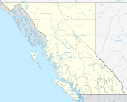 | |
|---|---|---|
| Communities | ||
| Metro areas and agglomerations | ||
| District municipalities |
| |
| ||
Municipalities and communities of Okanagan, British Columbia, Canada | ||
|---|---|---|
| Cities |  | |
| Towns | ||
| Districts | ||
| Villages | ||
| Designated places |
| |
| Unincorporated communities | ||
| Indian reservations | ||
| Ghost towns | ||
| Footnotes | ‡This populated place also has portions in an adjacent region | |
Coordinates: 49°36′02″N 119°40′40″W / 49.60056°N 119.67778°W