Sycamore, Missouri
| Sycamore, Missouri | |
|---|---|
| Community | |
|
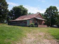
The old Sycamore store building on the north side of Route 181 | |
 Sycamore, Missouri Location of Sycamore, Missouri | |
| Coordinates: 36°42′12″N 92°16′28″W / 36.70333°N 92.27444°WCoordinates: 36°42′12″N 92°16′28″W / 36.70333°N 92.27444°W[1] | |
| Country | U. S. A. |
| State | Missouri |
| County | Ozark County |
| Elevation[1] | 250 m (820 ft) |
| Time zone | CST (UTC-6) |
| • Summer (DST) | CDT (UTC-5) |
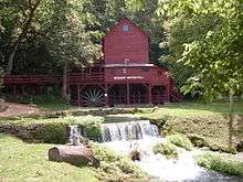
Sycamore is an unincorporated community in eastern Ozark County in the Ozarks of southern Missouri.[2] It is located on Route 181 about fourteen miles northeast of Gainesville. The old townsite is located on a ridge on the west side of Bryant Creek, a major tributary of the North Fork River. The old Hodgson Mill and spring lie on Bryant Creek 0.8 mi (1.3 km) to the northeast.[1] The mill was nominated to the National Register of Historic Places as Aid-Hodgson Mill in 2001.[3]
The community was founded in 1891 and named for a grove of American sycamore trees near the original town site.[4] The community post office was originally located in Hodgson Mill in 1891. The post office was later moved to the Sycamore store and remained active until 1973.[3][5]
References
- 1 2 3 Sycamore, Missouri, 7.5 Minute Topographic Quadrangle, USGS, 1968
- ↑ U.S. Geological Survey Geographic Names Information System: Sycamore
- 1 2 National Register of Historic Places Registration Form, Aid-Hodgson Mill, Ozark County, Missouri
- ↑ "Ozark County Place Names, 1928–1945". The State Historical Society of Missouri. Archived from the original on June 24, 2016. Retrieved November 27, 2016.
- ↑ Moser, Arthur Paul, A Directory of Towns, Villages, and Hamlets Past and Present of Ozark County, Missouri
Municipalities and communities of Ozark County, Missouri, United States | ||
|---|---|---|
| Cities | 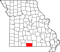 | |
| Villages | ||
| Townships |
| |
| CDPs | ||
| Other unincorporated communities | ||
| Ghost towns | ||