Toledo, Ozark County, Missouri
| Toledo, Missouri | |
|---|---|
| Community | |
 Toledo, Missouri Location of Toledo, Missouri | |
| Coordinates: 36°46′28″N 92°41′08″W / 36.77444°N 92.68556°WCoordinates: 36°46′28″N 92°41′08″W / 36.77444°N 92.68556°W[1] | |
| Country | U. S. A. |
| State | Missouri |
| County | Ozark County |
| Elevation[2] | 272 m (892 ft) |
| Time zone | CST (UTC-6) |
| • Summer (DST) | CDT (UTC-5) |
Toledo is an unincorporated community in Ozark County, in the U.S. state of Missouri.[1] Toledo is located in the valley of the Little North Fork White River about four miles north of Thornfield and Missouri Route 95.[2][3]
History
Toledo was formerly called Benners.[4] A post office was established as Benners in 1898, the name was changed to Toledo in 1910, and the post office closed in 1942.[5] The present name is a transfer from Toledo, Ohio.[6] Little remains of the original community since much of the surrounding area was given over to the Mark Twain National Forest.[4]
References
- 1 2 U.S. Geological Survey Geographic Names Information System: Toledo, Ozark County, Missouri
- 1 2 Smallett, Missouri, 7.5 Minute Topographic Quadrangle, USGS, 2004
- ↑ Thornfield, Missouri, 7.5 Minute Topographic Quadrangle, USGS, 2004
- 1 2 Harvey, Hank (Sep 11, 1994). "Missouri's Toledo is just a ghost town now". Toledo Blade. p. 6. Retrieved 6 October 2015.
- ↑ "Ozark County". Jim Forte Postal History. Retrieved 6 October 2015.
- ↑ "Ozark County Place Names, 1928–1945". The State Historical Society of Missouri. Archived from the original on June 24, 2016. Retrieved November 27, 2016.
Municipalities and communities of Ozark County, Missouri, United States | ||
|---|---|---|
| Cities | 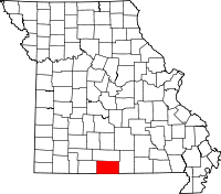 | |
| Villages | ||
| Townships |
| |
| CDPs | ||
| Other unincorporated communities | ||
| Ghost towns | ||
This article is issued from Wikipedia - version of the 11/28/2016. The text is available under the Creative Commons Attribution/Share Alike but additional terms may apply for the media files.