Timberon, New Mexico
| Timberon, New Mexico | |
|---|---|
| CDP | |
|
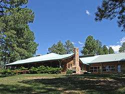
Timberon Lodge | |
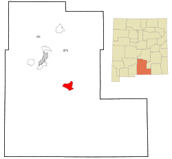 Location of Timberon, New Mexico | |
 Timberon, New Mexico Location in the United States | |
| Coordinates: 32°37′54″N 105°41′32″W / 32.63167°N 105.69222°WCoordinates: 32°37′54″N 105°41′32″W / 32.63167°N 105.69222°W | |
| Country | United States |
| State | New Mexico |
| County | Otero |
| Area | |
| • Total | 20.2 sq mi (52.3 km2) |
| • Land | 20.2 sq mi (52.3 km2) |
| • Water | 0.0 sq mi (0.0 km2) |
| Elevation | 6,929 ft (2,112 m) |
| Population (2010) | |
| • Total | 348 |
| • Density | 15.3/sq mi (5.9/km2) |
| Time zone | Mountain (MST) (UTC-7) |
| • Summer (DST) | MDT (UTC-6) |
| ZIP code | 88350 |
| Area code(s) | 575 |
| FIPS code | 35-77950 |
| GNIS feature ID | 0912792 |
Timberon is a census-designated place (CDP) in Otero County, New Mexico and is within the Sacramento Mountains at the southern edge of the Lincoln National Forest, directly north of the Fort Bliss Military Reservation. The population was 309 at the 2000 census.
Timberon has a 9-hole golf course, as well as a lodge, a pool, a church, an airstrip and a volunteer fire department. The residents consider it a retirement and resort community. Children are bussed into Cloudcroft for public school.[1]
Geography
Timberon is located at 32°37′54″N 105°41′32″W / 32.63167°N 105.69222°W (32.631675, -105.692254).[2] Elevation is 7150 feet.
According to the United States Census Bureau, the CDP has a total area of 20.2 square miles (52 km2), all of it land.
History
The land that now constitutes the community of Timberon was purchased from the State of New Mexico in 1933 by Judge Paul Moss. Moss had a hunting lodge there and cut some timber. In the 1960s the land was owned by Willie Farah, of [El Paso, Texas|El Paso] who built an airstrip there. Development of the community really began when the property was sold to the North American Land Development Corporation in March 1969. The volunteer fire department was begun in 1974, the firehouse was completed in 1981 and the post office opened that same year.[3] In 1976 a missile from White Sands Missile Range went awry and landed in the middle of the community.[4] The road into Timberon was paved in 2005.[3]
In July 2016 a devastating fire destroyed almost eighty structures, including forty-four homes in Timberon.[5][6][7]
Demographics
As of the census[8] of 2000, there were 309 people, 145 households, and 98 families residing in the CDP. The population density was 15.3 people per square mile (5.9/km²). There were 458 housing units at an average density of 22.7 per square mile (8.7/km²). The racial makeup of the CDP was 91.59% White, 0.32% Native American, 0.32% Asian, 4.21% from other races, and 3.56% from two or more races. Hispanic or Latino of any race were 12.62% of the population.
There were 145 households out of which 14.5% had children under the age of 18 living with them, 63.4% were married couples living together, 2.1% had a female householder with no husband present, and 32.4% were non-families. 29.7% of all households were made up of individuals and 14.5% had someone living alone who was 65 years of age or older. The average household size was 2.13 and the average family size was 2.52.
In the CDP the population was spread out with 16.2% under the age of 18, 3.6% from 18 to 24, 15.2% from 25 to 44, 36.6% from 45 to 64, and 28.5% who were 65 years of age or older. The median age was 54 years. For every 100 females there were 114.6 males. For every 100 females age 18 and over, there were 100.8 males.
The median income for a household in the CDP was $24,519, and the median income for a family was $25,804. Males had a median income of $13,000 versus $25,278 for females. The per capita income for the CDP was $11,743. About 2.9% of families and 9.5% of the population were below the poverty line, including none of those under the age of eighteen and 4.9% of those sixty five or over.
Education
In the 1970s children were bussed to the elementary school in Weed, New Mexico, but because of the difficulties of winter travel, a elementary school was established in December 1980 that operated just during the three winter months. The school building, known as the Little Red School House, offered Kindergarten through Sixth Grade instruction under the Alamogordo School District until 1992 when the Weed schools were closed. It continued under the administration of the Cloudcroft School District until May 2002, after which students were bussed to Cloudcroft.[3]
See also
References
- ↑ "Timberon FAQ". Timberon Development Council. Archived from the original on 11 November 2013.
- ↑ "US Gazetteer files: 2010, 2000, and 1990". United States Census Bureau. 2011-02-12. Retrieved 2011-04-23.
- 1 2 3 "History of Timberon". Timberon Development Council. Archived from the original on 11 November 2013.
- ↑ Kohut, John J. (1995). Stupid Government Tricks: Outrageous (But True!) Stories of Bureaucratic Bungling and Washington Waste. New York: Plume. p. 12. ISBN 978-0-452-27314-6.
- ↑ Gabbert, Bill (15 July 2016). "Wildfire burns approximately 30 homes in Timberon, New Mexico". Wildfire Today. Archived from the original on 7 August 2016.
- ↑ Pierce, David (18 July 2016). "Timberon Fire now 80 percent contained". KOAT-TV. Archived from the original on 1 December 2016.
- ↑ Warren, Jamie (21 September 2016) [First published 18 July 2016, later updated]. "Timberon fire destroys $130K home, homeowners did not have fire insurance". KVIA-TV. Archived from the original on 1 December 2016.
- ↑ "American FactFinder". United States Census Bureau. Retrieved 2008-01-31.
External links
| Wikimedia Commons has media related to Timberon, New Mexico. |
- The Timberon Mountaineer
- Timberon info pages from the Mountain Times
- Timberon Development Council, Inc.
Municipalities and communities of Otero County, New Mexico, United States | ||
|---|---|---|
| City | 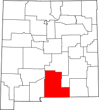 | |
| Villages | ||
| CDPs | ||
| Other unincorporated communities | ||
| Indian reservation | ||
| Footnotes | ‡This populated place also has portions in an adjacent county or counties | |