Troy, Kansas
| Troy, Kansas | |
|---|---|
| City | |
|
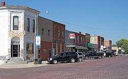
Troy business district with brick street (2006) | |
 Location within Doniphan County and Kansas | |
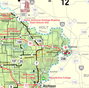 KDOT map of Doniphan County (legend) | |
| Coordinates: 39°47′17″N 95°5′27″W / 39.78806°N 95.09083°WCoordinates: 39°47′17″N 95°5′27″W / 39.78806°N 95.09083°W | |
| Country | United States |
| State | Kansas |
| County | Doniphan |
| Area[1] | |
| • Total | 0.99 sq mi (2.56 km2) |
| • Land | 0.98 sq mi (2.54 km2) |
| • Water | 0.01 sq mi (0.03 km2) |
| Elevation | 1,096 ft (334 m) |
| Population (2010)[2] | |
| • Total | 1,010 |
| • Estimate (2013)[3] | 994 |
| • Density | 1,030.6/sq mi (397.9/km2) |
| Time zone | Central (CST) (UTC-6) |
| • Summer (DST) | CDT (UTC-5) |
| ZIP code | 66087 |
| Area code(s) | 785 |
| FIPS code | 20-71575[4] |
| GNIS feature ID | 0473041[5] |
| Website | troykansas.com |
Troy is a city in and the county seat of Doniphan County, Kansas, United States.[6] As of the 2010 census, the city population was 1,010.[7] Troy is part of the St. Joseph, MO–KS Metropolitan Statistical Area.
History
Troy was platted in 1855.[8] It was named after the ancient city of Troy.[9] The first house in Troy was built in 1856, and the first store opened in 1857. Troy was incorporated as a city in 1860.[10] The first post office in Troy was established in March, 1857.[11]
Troy grew up from humble beginnings along the wagon route from St. Joseph, Missouri to Oregon and California. British explorer Richard Francis Burton en route to California in 1860 noted: "Passing though a few wretched shanties called Troy ..."[12]
Geography
Troy is located at 39°47′17″N 95°05′27″W / 39.788099°N 95.090840°W (39.788099, -95.090840).[13] According to the United States Census Bureau, the city has a total area of 0.99 square miles (2.56 km2), of which 0.98 square miles (2.54 km2) is land and 0.01 square miles (0.03 km2) is water.[1]
Demographics
| Historical population | |||
|---|---|---|---|
| Census | Pop. | %± | |
| 1860 | 131 | — | |
| 1870 | 639 | 387.8% | |
| 1880 | 694 | 8.6% | |
| 1890 | 730 | 5.2% | |
| 1900 | 750 | 2.7% | |
| 1910 | 940 | 25.3% | |
| 1920 | 1,013 | 7.8% | |
| 1930 | 1,042 | 2.9% | |
| 1940 | 1,049 | 0.7% | |
| 1950 | 977 | −6.9% | |
| 1960 | 1,051 | 7.6% | |
| 1970 | 1,047 | −0.4% | |
| 1980 | 1,240 | 18.4% | |
| 1990 | 1,073 | −13.5% | |
| 2000 | 1,054 | −1.8% | |
| 2010 | 1,010 | −4.2% | |
| Est. 2015 | 988 | [14] | −2.2% |
| U.S. Decennial Census[15] 2013 Estimate[3] | |||
2010 census
As of the census[2] of 2010, there were 1,010 people, 421 households, and 275 families residing in the city. The population density was 1,030.6 inhabitants per square mile (397.9/km2). There were 467 housing units at an average density of 476.5 per square mile (184.0/km2). The racial makeup of the city was 97.3% White, 0.5% African American, 0.2% Native American, 0.3% Asian, 0.2% from other races, and 1.5% from two or more races. Hispanic or Latino of any race were 2.7% of the population.
There were 421 households of which 31.4% had children under the age of 18 living with them, 49.6% were married couples living together, 10.0% had a female householder with no husband present, 5.7% had a male householder with no wife present, and 34.7% were non-families. 30.9% of all households were made up of individuals and 16.1% had someone living alone who was 65 years of age or older. The average household size was 2.38 and the average family size was 2.95.
The median age in the city was 39.1 years. 24.7% of residents were under the age of 18; 8.8% were between the ages of 18 and 24; 23.9% were from 25 to 44; 24.9% were from 45 to 64; and 17.3% were 65 years of age or older. The gender makeup of the city was 48.3% male and 51.7% female.
2000 census
As of the census[4] of 2000, there were 1,054 people, 439 households, and 295 families residing in the city. The population density was 1,473.4 people per square mile (565.2/km2). There were 474 housing units at an average density of 662.6 per square mile (254.2/km2). The racial makeup of the city was 98.77% White, 0.28% African American, 0.28% Native American, 0.09% Asian, 0.09% from other races, and 0.47% from two or more races. Hispanic or Latino of any race were 1.04% of the population.
There were 439 households out of which 31.4% had children under the age of 18 living with them, 54.0% were married couples living together, 8.9% had a female householder with no husband present, and 32.6% were non-families. 30.3% of all households were made up of individuals and 18.7% had someone living alone who was 65 years of age or older. The average household size was 2.38 and the average family size was 2.96.
In the city the population was spread out with 26.2% under the age of 18, 7.4% from 18 to 24, 26.7% from 25 to 44, 20.3% from 45 to 64, and 19.4% who were 65 years of age or older. The median age was 38 years. For every 100 females there were 98.1 males. For every 100 females age 18 and over, there were 93.5 males.
The median income for a household in the city was $31,786, and the median income for a family was $37,039. Males had a median income of $28,229 versus $19,706 for females. The per capita income for the city was $15,138. About 13.4% of families and 12.2% of the population were below the poverty line, including 16.2% of those under age 18 and 4.7% of those age 65 or over.
Notable people
- Chloe Gartner, American novelist.
- Charles "Buffalo" Jones, American frontiersman, farmer, rancher, hunter, and conservationist who cofounded Garden City, Kansas.
- Charles Evans Whittaker, Associate Justice of the United States Supreme Court from 1957 to 1962
References
- 1 2 "US Gazetteer files 2010". United States Census Bureau. Retrieved 2012-07-06.
- 1 2 "American FactFinder". United States Census Bureau. Retrieved 2012-07-06.
- 1 2 "Population Estimates". United States Census Bureau. Retrieved 2014-08-21.
- 1 2 "American FactFinder". United States Census Bureau. Retrieved 2008-01-31.
- ↑ "US Board on Geographic Names". United States Geological Survey. 2007-10-25. Retrieved 2008-01-31.
- ↑ "Find a County". National Association of Counties. Retrieved 2011-06-07.
- ↑ "2010 City Population and Housing Occupancy Status". U.S. Census Bureau. Retrieved March 27, 2011.
- ↑ History of the State of Kansas: Containing a Full Account of Its Growth from an Uninhabited Territory to a Wealthy and Important State. A. T. Andreas. 1883. p. 479.
- ↑ Kansas State Historical Society (1916). Biennial Report of the Board of Directors of the Kansas State Historical Society. Kansas State Printing Plant. p. 177.
- ↑ Blackmar, Frank Wilson (1912). Kansas: A Cyclopedia of State History, Volume 2. Standard Publishing Company. p. 821.
- ↑ "Kansas Post Offices, 1828-1961 (archived)". Kansas Historical Society. Archived from the original on October 9, 2013. Retrieved 8 June 2014.
- ↑ Richard Burton, (1862) The Look of the West 1860, Lincoln: Univ. Nebraska Press, reprint, n.d., p.23.
- ↑ "US Gazetteer files: 2010, 2000, and 1990". United States Census Bureau. 2011-02-12. Retrieved 2011-04-23.
- ↑ "Annual Estimates of the Resident Population for Incorporated Places: April 1, 2010 to July 1, 2015". Retrieved July 2, 2016.
- ↑ United States Census Bureau. "Census of Population and Housing". Retrieved August 21, 2014.
Further reading
- History of the State of Kansas; William G. Cutler; A.T. Andreas Publisher; 1883. (Online HTML eBook)
- Kansas : A Cyclopedia of State History, Embracing Events, Institutions, Industries, Counties, Cities, Towns, Prominent Persons, Etc; 3 Volumes; Frank W. Blackmar; Standard Publishing Co; 944 / 955 / 824 pages; 1912. (Volume1 - Download 54MB PDF eBook),(Volume2 - Download 53MB PDF eBook), (Volume3 - Download 33MB PDF eBook)
External links
| Wikimedia Commons has media related to Troy, Kansas. |
- City
- Schools
- USD 429, local school district
- Photos
- Tall Oak Indian Monument, KansasPhotoTour.com
- Troy - Kansas Historical Marker, Kansas Heritage.org
- Maps
- Troy City Map, KDOT
Municipalities and communities of Doniphan County, Kansas, United States | ||
|---|---|---|
| Cities |  | |
| CDP | ||
| Unincorporated communities | ||
| Ghost town | ||
| Indian reservation | ||
| Townships | ||
| Footnotes | ‡This populated place also has portions in an adjacent county or counties | |