U.S. Route 25
| |
|---|---|
 | |
| Route information | |
| Length: | 750 mi[1] (1,210 km) |
| Existed: | 1926[1] – present |
| Major junctions | |
| South end: |
|
|
| |
| North end: |
|
| Location | |
| States: | Georgia, South Carolina, North Carolina, Tennessee, Kentucky |
| Highway system | |

U.S. Route 25 (US 25) is a north–south United States highway that runs for 750 miles (1,210 km) from Brunswick, Georgia to the Ohio state line in Covington, Kentucky.
Route description
| mi | km | |
|---|---|---|
| GA | 190.0 | 305.8 |
| SC | 140.6 | 226.3 |
| NC | 75.4 | 121.3 |
| TN | 20.3 | 32.7 |
| 25E | 112.8 | 181.5 |
| 25W | 145.7 | 234.5 |
| KY | 177.3 | 285.3 |
| Total | 862.1 | 1,387.4 |
Georgia
Starting at the intersection of US 17/SR 25 in Brunswick, US 25 goes northwest to Jesup then northeast to Ludowici. It then stays at a general north route through the cities of Statesboro, Millen, Waynesboro and finally Augusta, where it crosses the Savannah River into South Carolina. The overall majority of the route is four-lane.[2]
South Carolina
Entering South Carolina from Augusta, Georgia, US 25 goes north through downtown North Augusta, connecting with I-20 just outside town. US 25 goes northwesterly through the cities of Edgefield, Greenwood, and Greenville; going due north at Travelers Rest to the North Carolina state line. Majority of the route is four-lane, with various sections at expressway grade.[3]
North Carolina
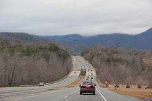
US 25 becomes a freeway from the state line in Tuxedo, in Henderson County. It continues for 9 miles (14 km) before connecting with I-26/US 74 near East Flat Rock. Splitting from I-26/US 74 near Fletcher, it goes north through Arden, Biltmore Forest, and downtown Asheville, before reconnecting with I-26 near Woodfin. At Weaverville, US 25 and US 70 travel northwesterly together, through Marshall and Hot Springs into Tennessee.[4]
Tennessee
In concurrency with US 70 and SR 9, US 25 enters the state through the Bald Mountains, followed by crossing the French Broad River along Wolf Creek Bridge. Along the northern bank of the French Broad River, it crosses back over and leaves the Cherokee National Forest. US 25 enters Newport, after crossing the Pigeon River, and serves as Broadway Street through the downtown area. At the western edge of Newport, US 25 splits: US 25E towards Morristown and US 25W towards Knoxville.[5]
U.S. Route 25E
Traversing a 112.8 miles (181.5 km) from Newport, Tennessee to North Corbin, Kentucky, US 25E connects the cities of White Pine, Morristown, Bean Station, Tazewell and Harrogate in Tennessee. Entering Kentucky via the Cumberland Gap Tunnel, it connects the cities of Middlesboro and Barbourville. In North Corbin, after merging back with US 25W, a US 25E connector continues west to I-75.
U.S. Route 25W
Traversing a 145.7 miles (234.5 km) from Newport, Tennessee to North Corbin, Kentucky, US 25W goes west connecting Dandridge, Knoxville and Clinton. Going north in parallel or in concurrency with I-75, it goes through Caryville, Jacksboro, La Follette and Jellico, before crossing the Tennessee/Kentucky line. Continuing north, it goes through Williamsburg before going through downtown Corbin and then reconnecting with US 25E in North Corbin.
Kentucky
US 25 starts again in North Corbin and traverses north, in parallel with I-75, connecting the cities of London, Berea, Richmond, Lexington and Dry Ridge. US 25 ends in Covington at the Ohio state line over the Ohio River along Clay Wade Bailey Bridge; US 42/US 127 continue into Cincinnati.
ADHS corridors
US 25 overlaps with three corridors that are part of the Appalachian Development Highway System (ADHS), which is part of Appalachian Regional Commission (ARC). Passed in 1965, the purpose of ADHS is to generate economic development in previously isolated areas, supplement the interstate system, connect Appalachia to the interstate system, and provide access to areas within the Region as well as to markets in the rest of the nation.[6]
- Corridor F: From I-75, in Caryville, Tennessee, to US 23, in Jenkins, Kentucky. US 25W overlaps a 8.5-mile (13.7 km) section in Caryville; though already a four-lane boulevard, it is slated to be improved upon in that area. US 25E overlaps a 15.0-mile (24.1 km) section, centered around the Cumberland Gap area. From Harrogate, Tennessee to Pineville, Kentucky, US 25E is a mostly four-lane limited-access road with interchanges at major intersections.[7][8]
- Corridor S: From I-81, near Morristown, Tennessee, to SR 63, in Harrogate, Tennessee. The entire 48.7-mile (78.4 km) section of US 25E is authorized for ADHS funding. As of 2013, 22.2 miles (35.7 km) is still slated for construction along the route. Cutting through various mountain ridges, US 25E provides a four-lane limited-access road with interchanges at major intersections.[7]
- Corridor W: From I-85, in Greenville, South Carolina, to I-26/US 74, near East Flat Rock, North Carolina. Of the 39.7-mile (63.9 km) section of US 25, only 30.4-mile (48.9 km) was authorized for ADHS funding. In 2013, both states have completed Corridor W. US 25 in South Carolina provides a four-to-six-lane limited-access road, with interchanges at major intersections; while US 25 in North Carolina is a four-lane controlled-access highway.[9][10]
History

US 25 was established on November 11, 1926 as part of the original United States Numbered Highway system; it was routed along the Dixie Highway, from North Augusta, South Carolina to Port Huron, Michigan, with a two divides (US 25E/US 25W) through Tennessee and Kentucky. In 1928, one divided section between Richmond and Newport, Kentucky was removed; US 25 followed the US 25W routing, while US 25E was replaced by mostly US 27. In 1929, US 25 was extended south into Georgia, ending at US 80, near Statesboro, Georgia. In 1933, US 25 was extended north from Port Huron to Port Austin, Michigan. In 1936, US 25 was extended south again to its current terminus at US 17, in Brunswick, Georgia.
In 1974, US 25 was eliminated in Ohio and Michigan, establishing its northern terminus on the Clay Wade Bailey Bridge, in Covington, Kentucky. Its former alignment was replaced by Interstate 75, between Cincinnati and Detroit, and Interstate 94 between Detroit and Port Huron. M-25 continues as the designation of former US 25 between Port Huron and Port Austin.
In 2000, US 25E was rerouted through the Cumberland Gap Tunnel (open four years prior), making a direct link between Tennessee and Kentucky, eliminating Virginia's short section. Its old alignment that went through historic Cumberland Gap was handed over to the Cumberland Gap National Historical Park, with the former roadbed through the park restored to an early 19th-century wagon path.[11][12]
Major intersections
- Southern segment
- Georgia
-
 US 17 in Brunswick
 -
 US 341 in Brunswick. The highways travel concurrently to Jesup.
 -
 I‑95 in Dock Junction
 -
 US 301 / US 341 in Jesup. US 25/US 301 travel concurrently to Statesboro.
 -
 US 84 in Jesup. The highways travel concurrently to Ludowici.
 -
 US 280 in Claxton
 -
 I‑16 south-southeast of Register
 -
 US 80 in Statesboro. The highways travel concurrently to Hopeulikit.
 -
 I‑520 in Augusta
 -


 US 1 / US 78 / US 278 in Augusta. The highways travel concurrently to North Augusta, South Carolina.
-
- South Carolina
-
 I‑20 in North Augusta
 -
 US 378 north-northwest of Edgefield
 -
 US 178 south-southeast of Greenwood. The highways travel concurrently to southeast of Hodges.
 -
 US 221 in Greenwood. The highways travel concurrently through the city.
 -
 US 76 in Princeton. The highways travel concurrently to northwest of Princeton.
 -
 I‑185 south of Gantt
 -
 I‑85 on the Gantt–Greenville city line
 - I‑185 south-southwest of Dunean
-
 US 123 on the Welcome–Parker city line
 -
 US 276 south of Travelers Rest. The highways travel concurrently, but on different lanes, to Travelers Rest.
-
- North Carolina
-
 US 176 south of East Flat Rock
 -

 I‑26 / US 74 east of East Flat Rock. The highways travel concurrently to Fletcher.
 -
 US 64 in Hendersonville
 -
 I‑40 in Asheville
 -

 I‑240 / US 70 in Asheville
 -
.svg.png)

 Future I‑26 / US 19 / US 23 / US 70 in Woodfin. I-26/US 19/US 23/US 25 travel concurrently to Weaverville. US 25/US 70 travel concurrently to Newport, Tennessee.
-
- Tennessee
- Northern segment
- Kentucky
-

 US 25E / US 25W in North Corbin
 -
 I‑75 east-southeast of Mt. Vernon
 -
 US 150 in Mt. Vernon
 - I‑75 in Mt. Vernon
-
 US 421 south-southeast of Richmond. The highways travel concurrently to Lexington.
 - I‑75 in Richmond
- I‑75 south-southeast of Lexington. The highways travel concurrently to Lexington.
-
 US 60 in Lexington. The highways travel concurrently through the city.
 -

 US 27 / US 60 / US 68 in Lexington
 -

 US 62 / US 460 in Georgetown
 -

 US 42 / US 127 in Florence. The highways travel concurrently to the Ohio state line.
 -
 I‑275 in Crestview Hills
 -
 I‑71 / I‑75 in Fort Mitchell
 - I‑71 / I‑75 in Covington
-
See also
References
- 1 2 US Highways from US 1 to US 830 Robert V. Droz
- ↑ Google (April 6, 2014). "Route of US 25 (Brunswick to Millen)" (Map). Google Maps. Google. Retrieved April 6, 2014.
Google (April 6, 2014). "U.S. Route 25 in Georgia" (Map). Google Maps. Google. Retrieved April 6, 2014. - ↑ Google (June 29, 2013). "U.S. Route 25 in South Carolina" (Map). Google Maps. Google. Retrieved June 29, 2013.
- ↑ Google (February 26, 2011). "U.S. Route 25 in North Carolina" (Map). Google Maps. Google. Retrieved February 26, 2011.
- ↑ Google (July 2, 2014). "U.S. Route 25 in Tennessee" (Map). Google Maps. Google. Retrieved July 2, 2014.
- ↑ "Appalachian Development Highway System". Appalachian Regional Commission. Retrieved June 30, 2014.
- 1 2 "Status of Corridors in Tennessee" (PDF). Appalachian Regional Commission. September 30, 2013. Retrieved July 2, 2014.
- ↑ "Status of Corridors in Kentucky" (PDF). Appalachian Regional Commission. September 30, 2013. Retrieved July 2, 2014.
- ↑ "Status of Corridors in South Carolina" (PDF). Appalachian Regional Commission. September 30, 2013. Retrieved June 29, 2014.
- ↑ "Status of Corridors in North Carolina" (PDF). Appalachian Regional Commission. September 30, 2013. Retrieved June 29, 2014.
- ↑ Kenison, Leon (April 8, 2000). "Report of the Special Committee on U.S. Route Numbering to the Standing Committee on Highways" (PDF) (Report). St. George, UT: American Association of State Highway and Transportation Officials. Retrieved July 2, 2014.
- ↑ "Cumberland Gap Tunnel". Retrieved September 13, 2010.
External links
| Wikimedia Commons has media related to U.S. Route 25. |
| Browse numbered routes | ||||
|---|---|---|---|---|
| ← | TN | SR 25 | ||
| ← | list | KY 26 | ||
Routes in italics are no longer a part of the system. Highlighted routes are considered main routes of the system. |