Udhampur district
| Udhampur district | |
|---|---|
| District | |
| Country | India |
| State | Jammu and Kashmir |

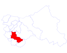
Udhampur is a district in the Indian state of Jammu and Kashmir. It covers an area of 4,550 square kilometers in the Himalayan mountains. Udhampur town is the headquarters of this district.
At an elevation of 1,584 m, Vaishno Devi cave near Katra is an important shrine for the Hindus and the most famous tourist attraction of the district. Vaishno Devi in 2011 was visited by over 10 million pilgrims.[1] At an elevation of 2,024 m the mountain resort of Patnitop and the temple at Sudh Mahadev believed to be over 2800 years old,[2] are other popular tourist attractions of the district. Major attractions in Udhampur city include Gole Market, Devika Ghats, Jakhani Park, Ramnagar chowk (Pandav mandir and Kachalu), Salain Talab, and the Main Bazar.
The major languages spoken in the district are Dogri, Hindi, Urdu, and Gojri.
Weather conditions
Temperature varies considerably in the Udhampur District, as the altitude ranges from 600 m to 3,000 m. Chenab, Ans, Tawi and Ujh are the main rivers. The district is rich in minerals such as coal, bauxite, gypsum and lime-stone.
Administration
Udhampur district comprises seven tehsils (Chenani, Ramnagar Tehsil, Majalta and seven blocks, namely, Dudu Basantgarh, Gordi, Chenani, Bajalta, Panchari, Ramnagar and Udhampur.[3] Each block consists of a number of panchayats.
Demographics
The 2001 census indicates the population of the district to be 459,486.[4] There are 871 females for every 1000 males in the district. The overall literacy rate is 54.16%, with 66.43% for males and 39.89% for females. The majority of the population of the district practice Hinduism. The majority are Dogras in this district. There are a large number of nomadic Gujjars and Bakarwals present in the district as well.
According to the 2011 census Udhampur district has a population of 555,357,[5] roughly equal to the EU nation of Luxembourg[6] or the US state of Wyoming.[7] This gives it a ranking of 538th in India (out of a total of 640).[5] The district has a population density of 211 inhabitants per square kilometre (550/sq mi).[5] Its population growth rate over the decade 2001-2011 was 20.86%.[5] Udhampur has a sex ratio of 863 females for every 1000 males,[5] and a literacy rate of 69.9%.[5]
The religious composition of the district is: Hindu 88.12%, Muslim 10.77%[8]
Tourist attractions
The most famous among the historical places and monuments are the Babore Temples, Kiramchi Temples, Sheesh Mahal of Ramnagar, Ramnagar Fort, Shankari Devtaa Mandir in Pancheri, shrines of Chountra Devi and Pingla Devi. Tourist spots include Patnitop, Sanasar, and Latti.
Temples
Owing to a multitude of shrines and temples, Udhampur is also known as Devika Nagari meaning City of the Goddess. Places of worship located in the district include Babore Temples, Kansar Devta's shrine, Shaankari Devta mandir, Shiv Khori Cave Temple, Bhairav Ghati, Krimchi Temples, Shiv Parvathi Cave shrine, Cairhai, Mutal Pingla Devi shrine, Shri Mata Vaishno Devi shrine, Deva Mayi Maa Temple, Sheshnag Shrine.
In the 7th century text, the Nilmat Puran by Nela Muni, it is mentioned that the Devika River is a manifestation of the mother Goddess Parwati to benefit people of Mader Desha that covers the areas between river Ravi and Chenab and the river Devika and appears on the Shiv Ratri. Lord Shiva and his consort Uma are believed to manifest together at eight places alongside the Devika river. The subterranean river Devika presently flows under a sandy surface.[9]
In Devi Mahatmya it is mentioned, that there is no need to perform Japa or any ritual for obtaining spiritual benefits at this pilgrimage site, but only to touch the Devika waters or bathing in them. Water from the Devika can be retrieved by digging a foot into the sand bed. Cremation on the sands of Devika is considered as meritorious as on the banks of the Ganges at Kashi.
Cities and towns
Batle, Mansar, Thabu, Chenani, Narsu, Thalora, Domail, Ramkot, Jib, Udhampur, Jagoonu, Ramnagar, Patnitop, Manwal, Kishanpur, Reasi, Katra, Tangar, Sansoo, Balwalta, Pancheri, Garhi, Chopra Bazaar, Palthyar.
Military
The Northern Command Headquarters of the Indian Army is based in Udhampur and consists of three Corps, the XIV, XV, and XVI. All units are deployed along the Line of Control in Kashmir, with the exceptions of the 39th Infantry Division, and the 2nd, 3rd, and 16th Independent Armored Brigades.
Prior to Independence, Northern Command Headquarters was located at Rawalpindi, and was responsible for the defence of North West India. After Partition, the Command Headquarters was allocated to Pakistan. In India, a new Headquarters designated as Western Command was located at Shimla to look after the Northern borders with Pakistan and some portions of Tibet.
The need for a separate Headquarters in the North was felt during First Kashmir War in 1948. The experience of wars in 1962, 1965 and 1971 reinforced the conviction that the Northern Theatre needed to be commanded by a Headquarters based at Shimla. The 1965 and 1971 Wars demonstrated that the area under General Officer Commanding-in-Chief Western Command was too vast for effective command.
Accordingly, in 1971, duplicate headquarters with duplicated staff were set up at Shimla and Bhatinda. After 1971, Headquarter Northern Command was established at Udhampur, taking over responsibility for Jammu, Kashmir and Ladakh.
It was decided in June 1972 to raise Northern Command at Udhampur, with two corps under it, to look after the defence of this region. This strength has now increased to three corps. Northern Command now controls this sensitive region of the country which covers the entire state of Jammu and Kashmir and contiguous portions of Punjab and Himachal Pradesh.
The first GOC-in-C of Northern Command was Lt Gen PS Bhagat. The command has been in the operational mode since its inception. It saw a number of high and low intensity operations.
Troops of the Northern Command have been manning the highest battlefield in the world at the Siachen Glacier where the altitude of the posts varies from 15,000 to 23,000 ft.
This command has played a crucial role in fighting against the proxy war that began in 1990. Over 18,000 terrorists have been killed, more than 80 tons of explosives and almost 40,000 weapons have been recovered. The command also took the onus of fencing the Line of Control to curtail the levels of infiltration and exfiltration.
The XIV Corps is the field formation that is responsible for Ladakh and Kargil, and is responsible for intelligence about enemy positions near the Line of Control. The Kargil operation in 1999 was primarily the responsibility of the 8 Mountain Division, the formation that was rushed there after the intrusions were detected in May 1999. 56 Mountain Brigade deployed two battalions to contain intrusions in Mashkoh and Dras while the third battalion (18 Grenadiers) established the crucial firm base 1000 feet below Tololing at 15,000 feet. 8 Mountain Div was tasked to clear nearly 50 pockets of intrusions in Mashkoh. Of the 16 battalions involved in the war, only 10 were employed at Kargil. 8 Mountain Division played a major role in evicting intrusions and defeating the Pakistan army at Kargil. It switched in 1990 from a counterinsurgency division in the North-East to the Srinagar valley and now to a high altitude mountain division at Kargil.
XVI Corps is believed to be one of the largest corps in the world as it consists of five divisions.
As of mid-1999 there were two divisions, comprising approximately 15,000 soldiers each, manning the LoC and the Line of Actual Control with China from Kargil to Siachen. While the 8 Mountain Division had been given sole charge of guarding 150 kilometers of the border in the Kargil sector, the 3 Infantry Division was in charge of Siachen and the Aksai Chin border. Significantly, as the 15 Corps mobilised its forces for the counterattack and elements of the 18 Mountain Division poured into the various sectors of Kargil, the people of Jammu & Kashmir were steadfast against the enemy forces.
With the induction of 14 Corps into Ladakh, the supply-load on the Army Service Corps (ASC) has increased tremendously. Given the politico-military situation on India's borders, a large portion of the army is deployed in some of the most inhospitable terrain. As of early 2002 these units had been joined by Central Command's I Corps Strike Force consisting of three divisions.
The Indian Army announced the creation of its new command known as South Western Command with its Headquarters at Jaipur, which formally came into being on 18 April 2005. the South-Western Command, will operate in conjunction with the Udhampur-based Northern Command and Chandimandir-based Western Command. The reallocation of forces to the South-Western Command from Northern Command and Western Command was not immediately apparent.
For an effective operational preparedness in the western sector, in mid-2005 Indian Army raised a new corps at Yol Cantt in Kangra Valley of Himachal Pradesh. The new corps, christened 9 Corps, comprises 26 and 29 Infantry Divisions, which had previously been allocated to XVI Corps / Nagrota Corps, and a number of brigades.
Politics
Udhampur District has 3 assembly constituencies: Udhampur, Chenani and Ramnagar. National Panthers party has good following in the Udhampur district followed by BJP and INC.[10]
References
- ↑ "Vaishno Devi will get over 1 crore pilgrims this year: Officials". NDTV. 24 October 2012. Retrieved 2016-11-12.
- ↑ Lovell-Hoare, Max; Lovell-Hoare, Sophie (2014-07-01). Kashmir: Jammu. Kashmir Valley. Ladakh. Zanskar. Bradt Travel Guides. ISBN 9781841623962.
- ↑ Statement showing the number of blocks in respect of 22 Districts of Jammu and Kashmir State including newly Created Districts dated 2008-03-13, accessed 2008-08-30
- ↑ "Udhampur District Population Census 2011, Jammu and Kashmir literacy sex ratio and density". Census 2011 India. Retrieved 2016-11-08.
- 1 2 3 4 5 6 "District Census 2011". Census2011.co.in. 2011. Retrieved 2011-09-30.
- ↑ "The first results of the population census". Grand Duchy of Luxembourg: Statical Portal. 2012-07-11. Retrieved 2016-10-08.
Luxembourg grew by 72 814 and reached, by February 1st 2011, 512 353 inhabitants.
- ↑ "2010 Resident Population Data". U. S. Census Bureau. Retrieved 2011-09-30.
Wyoming 563,626
- ↑ http://www.census2011.co.in
- ↑ "Reclaiming holy Devika". Daily Excelsior. 2016-08-15. Retrieved 2016-11-08.
- ↑ "ERO's and AERO's". Chief Electoral Officer, Jammu and Kashmir. Retrieved 2008-08-28.
External links
- http://udhampur.nic.in
- List of places in Udhampur
 |
Reasi district | Ramban district | Doda district | |
| Jammu district | |
|||
| ||||
| | ||||
| Samba district | Kathua district |
Coordinates: 33°00′N 75°10′E / 33.000°N 75.167°E