Wheatland, North Dakota
| Wheatland | |
|---|---|
| Census-designated place | |
|
Wheatland | |
 Wheatland Location within the state of North Dakota | |
| Coordinates: 46°54′26″N 97°20′57″W / 46.90722°N 97.34917°WCoordinates: 46°54′26″N 97°20′57″W / 46.90722°N 97.34917°W | |
| Country | United States |
| State | North Dakota |
| County | Cass |
| Area | |
| • Total | 4.0 sq mi (10 km2) |
| • Land | 4.0 sq mi (10 km2) |
| Population (2010)[1] | |
| • Total | 68 |
| • Density | 17/sq mi (6.6/km2) |
| Time zone | Central (CST) (UTC-6) |
| • Summer (DST) | CST (UTC-5) |
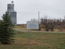
Wheatland is a census-designated place (CDP) in Cass County, North Dakota in the United States. The population was 68 at the 2010 census.[1]
History
A post office called Wheatland has been in operation since 1878.[2] The community was named for the wheat field near the original town site.[3]
Geography
Wheatland is located at 46°54′26″N 97°20′57″W / 46.90722°N 97.34917°W (46.907252, -97.349037).[4]
According to the United States Census Bureau, the CDP has a total area of 4.0 square miles (10 km2), all of it land.
Demographics
As of the census[5] of 2000, there were 60 people, 22 households, and 17 families residing in the CDP. The population density was 15.0 people per square mile (5.8/km²). There were 28 housing units at an average density of 7.0/sq mi (2.7/km²). The racial makeup of the CDP was 100.00% White.
There were 22 households out of which 45.5% had children under the age of 18 living with them, 68.2% were married couples living together, 13.6% had a female householder with no husband present, and 18.2% were non-families. 18.2% of all households were made up of individuals and 4.5% had someone living alone who was 65 years of age or older. The average household size was 2.73 and the average family size was 3.11.
In the CDP the population was spread out with 33.3% under the age of 18, 8.3% from 18 to 24, 21.7% from 25 to 44, 28.3% from 45 to 64, and 8.3% who were 65 years of age or older. The median age was 36 years. For every 100 females there were 122.2 males. For every 100 females age 18 and over, there were 100.0 males.
The median income for a household in the CDP was $37,083, and the median income for a family was $55,625. Males had a median income of $35,000 versus $14,000 for females. The per capita income for the CDP was $16,084. None of the population and none of the families were below the poverty line.
References
- 1 2 "2010 Census Redistricting Data (Public Law 94-171) Summary File". American FactFinder. United States Census Bureau. Retrieved 2 May 2011.
- ↑ "Cass County". Jim Forte Postal History. Retrieved 22 October 2015.
- ↑ Federal Writers' Project (1938). North Dakota, a Guide to the Northern Prairie State,. WPA. p. 279. ISBN 978-1-62376-033-5.
- ↑ "US Gazetteer files: 2010, 2000, and 1990". United States Census Bureau. 2011-02-12. Retrieved 2011-04-23.
- ↑ "American FactFinder". United States Census Bureau. Retrieved 2008-01-31.
External links
Municipalities and communities of Cass County, North Dakota, United States | ||
|---|---|---|
| Cities | 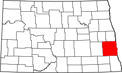 | |
| Townships |
| |
| CDPs | ||
| Unincorporated communities | ||
| Footnotes | ‡This populated place also has portions in an adjacent county or counties | |
| Counties | ||
|---|---|---|
| Main cities | ||
| Surrounding areas |
| |
‡ - county seat | ||