Windom, Minnesota
| Windom, Minnesota | |
|---|---|
| City | |
|
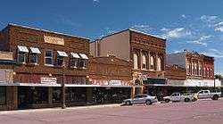
Shops in downtown Windom | |
 Location of Windom within Cottonwood County, Minnesota | |
| Coordinates: 43°52′6″N 95°7′7″W / 43.86833°N 95.11861°W | |
| Country | United States |
| State | Minnesota |
| County | Cottonwood |
| Platted | 1871 |
| Incorporated | 1875 |
| Government | |
| • Type | Mayor–council |
| • Mayor | Dominic Jones (2017) |
| Area[1] | |
| • Total | 4.33 sq mi (11.21 km2) |
| • Land | 4.16 sq mi (10.77 km2) |
| • Water | 0.17 sq mi (0.44 km2) |
| Elevation | 1,362 ft (415 m) |
| Population (2010)[2] | |
| • Total | 4,646 |
| • Estimate (2015) | 4,550[3] |
| • Density | 1,116.8/sq mi (431.2/km2) |
| Time zone | Central (CST) (UTC-6) |
| • Summer (DST) | CDT (UTC-5) |
| ZIP codes | 56101, 56118 |
| Area code(s) | 507 |
| FIPS code | 27-70798[4] |
| GNIS feature ID | 0654245[5] |
| Website |
www |
Windom is a city in Cottonwood County, Minnesota, United States. The population was 4,646 at the 2010 census.[6] It is the county seat of Cottonwood County[7] and is situated in the Coteau des Prairies.
Although it is a small, rural farming community, Windom is host to several parks including a newly installed disc golf course at Mayflower Park. The Des Moines River flows through Windom and serves as a gentle, rapid-free canoeing spot.
History
Windom was platted in June 20, 1871 by A.L. Beach, an engineer for the Sioux City and St. Paul Railroad.[8][9] Twelve lots were created and sold for $100 on the first day.[10] It was incorporated as a village in 1875 and reincorporated on September 9, 1884.[10] The city was named after William Windom, who served as a United States Senator from Minnesota from 1881–1883, and was United States Secretary of the Treasury under presidents James Garfield, Chester Arthur and Benjamin Harrison, by Judson W. Bishop.[10][11]
Geography
Windom lies 1,362 feet (415 m) above sea level. According to the United States Census Bureau, the city has a total area of 4.33 square miles (11.21 km2), of which, 4.16 square miles (10.77 km2) is land and 0.17 square miles (0.44 km2) is water.[1] Windom is located on the Coteau des Prairies, a ridge extending from South Dakota to Iowa separating Cottonwood County into two watersheds.[12] The watersheds drain into the Minnesota and Mississippi rivers.[12] The Des Moines River flows through Windom.[13]
Climate
The average mean Winter temperature in Windom is 16 °F (−9 °C), in Spring it is 44.7 °F (7.1 °C), in Summer it is 69.8 °F (21.0 °C), and in Fall it is 46.1 °F (7.8 °C)[14] The record high for Windom was set on August 1, 1988 at 105 °F (41 °C)[15] The record low was set on January 7, 1988 at −36 °F (−38 °C).[15] The maximum rainfall was 8.84 inches (225 mm), achieved on September 23, 2010.[15]
| Climate data for Windom, Minnesota | |||||||||||||
|---|---|---|---|---|---|---|---|---|---|---|---|---|---|
| Month | Jan | Feb | Mar | Apr | May | Jun | Jul | Aug | Sep | Oct | Nov | Dec | Year |
| Record high °F (°C) | 65 (18) |
66 (19) |
84 (29) |
93 (34) |
98 (37) |
103 (39) |
103 (39) |
105 (41) |
100 (38) |
91 (33) |
80 (27) |
64 (18) |
105 (41) |
| Average high °F (°C) | 27 (−3) |
32 (0) |
44 (7) |
60 (16) |
72 (22) |
82 (28) |
85 (29) |
82 (28) |
75 (24) |
61 (16) |
43 (6) |
29 (−2) |
85 (29) |
| Average low °F (°C) | 7 (−14) |
12 (−11) |
24 (−4) |
35 (2) |
47 (8) |
57 (14) |
62 (17) |
59 (15) |
50 (10) |
37 (3) |
24 (−4) |
11 (−12) |
7 (−14) |
| Record low °F (°C) | −36 (−38) |
−31 (−35) |
−25 (−32) |
6 (−14) |
20 (−7) |
33 (1) |
42 (6) |
32 (0) |
22 (−6) |
9 (−13) |
−17 (−27) |
−28 (−33) |
−36 (−38) |
| Average precipitation inches (mm) | .9 (23) |
.75 (19) |
1.97 (50) |
3.24 (82.3) |
3.55 (90.2) |
4.56 (115.8) |
4.05 (102.9) |
3.52 (89.4) |
3.29 (83.6) |
2.18 (55.4) |
1.67 (42.4) |
.98 (24.9) |
30.66 (778.9) |
| Source: Weather.com[16] | |||||||||||||
Demographics
| Historical population | |||
|---|---|---|---|
| Census | Pop. | %± | |
| 1880 | 443 | — | |
| 1890 | 835 | 88.5% | |
| 1900 | 1,944 | 132.8% | |
| 1910 | 1,749 | −10.0% | |
| 1920 | 2,123 | 21.4% | |
| 1930 | 2,123 | 0.0% | |
| 1940 | 2,807 | 32.2% | |
| 1950 | 3,165 | 12.8% | |
| 1960 | 3,691 | 16.6% | |
| 1970 | 3,952 | 7.1% | |
| 1980 | 4,666 | 18.1% | |
| 1990 | 4,283 | −8.2% | |
| 2000 | 4,490 | 4.8% | |
| 2010 | 4,646 | 3.5% | |
| Est. 2015 | 4,550 | [3] | −2.1% |
| U.S. Decennial Census | |||
2010 census
As of the census[2] of 2010, there were 4,646 people, 1,994 households, and 1,201 families residing in the city. The population density was 1,116.8 inhabitants per square mile (431.2/km2). There were 2,171 housing units at an average density of 521.9 per square mile (201.5/km2). The racial makeup of the city was 92.1% White, 1.4% African American, 0.3% Native American, 1.2% Asian, 0.3% Pacific Islander, 3.7% from other races, and 1.1% from two or more races. Hispanic or Latino of any race were 8.0% of the population.
There were 1,994 households of which 26.9% had children under the age of 18 living with them, 47.4% were married couples living together, 9.4% had a female householder with no husband present, 3.5% had a male householder with no wife present, and 39.8% were non-families. 35.7% of all households were made up of individuals and 16.3% had someone living alone who was 65 years of age or older. The average household size was 2.25 and the average family size was 2.91.
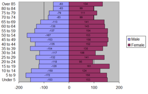
The median age in the city was 42.6 years. 23.2% of residents were under the age of 18; 6.8% were between the ages of 18 and 24; 23.1% were from 25 to 44; 25.8% were from 45 to 64; and 21.2% were 65 years of age or older. The gender makeup of the city was 48.2% male and 51.8% female.
2000 census
As of the census[4] of 2000, there were 4,490 people, 1,910 households, and 1,195 families residing in the city. The population density was 1,263.6 people per square mile (488.3/km²). There were 2,089 housing units at an average density of 587.9 per square mile (227.2/km²). The racial makeup of the city was 97.15% White, 0.24% African American, 0.33% Native American, 0.71% Asian, 0.11% Pacific Islander, 0.85% from other races, and 0.60% from two or more races. Hispanic or Latino of any race were 1.58% of the population.
There were 1,910 households out of which 27.7% had children under the age of 18 living with them, 50.6% were married couples living together, 8.9% had a female householder with no husband present, and 37.4% were non-families. 34.0% of all households were made up of individuals and 17.2% had someone living alone who was 65 years of age or older. The average household size was 2.25 and the average family size was 2.87.
In the city the population was spread out with 23.7% under the age of 18, 6.6% from 18 to 24, 24.4% from 25 to 44, 23.6% from 45 to 64, and 21.7% who were 65 years of age or older. The median age was 42 years. For every 100 females there were 87.6 males. For every 100 females age 18 and over, there were 84.7 males.
The median income for a household in the city was $30,744, and the median income for a family was $43,350. Males had a median income of $30,053 versus $21,270 for females. The per capita income for the city was $17,155. About 5.7% of families and 9.6% of the population were below the poverty line, including 13.1% of those under age 18 and 11.0% of those age 65 or over.
Government
Windom is located in Minnesota's 1st congressional district, represented by Tim Walz, a Democrat. At the state level, Windom is located in Senate District 22, represented by Republican Bill Weber, and in House District 22B, represented by Republican Rod Hamilton.[17]
Windom operates under a Mayor-Council plan.[18] The council consists of 5 members representing 2 wards that are each separated into 2 precincts.[18] Four of the council members represent an individual precinct and serve 4-year terms; the final council member is an at-large candidate and serves a 2-year term.[18] Prior to the introduction of a new city charter on June 20, 1984,[19] council members in Windom were referred to as alderpersons.[20]
Infrastructure
Transportation

U.S. Highway 71, Minnesota Highway 60, and Minnesota Highway 62 are three of the main routes through the city.
Economy
On December 1, 1987, Windom adopted the Minnesota "Star City" program to promote economic development and pursue the "Star City" designation.[21][22] The city received the designation in August, 1988.[22]
The largest employers in Windom are Toro, Windom Public Schools-ISD 177, and Fortune Transportation with 600, 176, and 175 employees respectively.[14] Windom is home to one of eight Toro manufacturing facilities.[23] It is also the headquarters of Big Game Treestands.[24]
Windom has a labor force of 2,378 of which 2,295 are employed; 85 are unemployed creating an unemployment rate of 3.5%.[25] The largest industries are educational services, and health care and social assistance with 26.3% of the employed population and manufacturing with 18.6% of the employed population.[25]
Media
The town is served by the Cottonwood County Citizen, a weekly newspaper.[26]
The town is also served by three radio stations licensed to the town, two of which are commercial and one non-commercial.
| Callsign | Frequency | Format | Owner | Reference |
|---|---|---|---|---|
| KDOM | 1580 | Full Service | Windom Radio Incorporated | [27] |
| KJWR | 90.9 | Religious | Minn-Iowa Christian Broadcasting Inc. | [28] |
| KDOM-FM | 94.3 | Country | Windom Radio Incorporated | [29] |
Education
Windom is home to several schools: Windom Area Middle/High School, Winfair Elementary School, Bridges Preschool and Red Rock Ridge ALC. It is also home to two private or church preschools: Busy Bees and Sunshine School.
Windom Area Middle/High School
Windom Area Middle/High School is home to students grade 4-12 due to renovations in 2003.[30] The building originally only housed grades 5-12 after the renovations, but had to accommodate the 4th grade students starting in 2011 due to overcrowding in the elementary school building. There are roughly 300 students attending the high school (grades 9-12) and 350 attending the middle school (grades 4-8).[30] The school is led by Principal Jake Tietje and Superintendent Wayne Wormstadt.[31]
Entertainment
Riverfest
Windom holds an annual summer festival called Riverfest during the second weekend of June. A pageant corresponds to this celebration which crowns a Miss Riverfest, a First Runner-Up, Miss Photogenic, Miss Congeniality and a Little Miss Riverfest. Other activities in this weekend celebration include: fireworks, Vickie Schendel 5K Walk/Run, tennis tourney, fishing tourney, turtle races, kiddie tractor pull, street dance, grand parade, and many more.
Winter-River-Fest
In February 2011 Windom started a new festival dubbed "Winter-River-Fest." Activities included a chili feed, open fires, dodge ball, snow sculpting, and the Darn Cold Croquet Contest.[32]
Notable people
- Larry Buhler - professional football player
- Elaine Harder - Minnesota state legislator
- Aaron Horkey - artist
- Johnny Olson - game show announcer
- Maria Schneider - Grammy Award-winning jazz composer
References
- Brown, John A. History of Cottonwood and Watonwan Counties, Minnesota: Their People, Industries, and Institutions. B.F. Bowen & Co.: Indianapolis, 1916.
- 1 2 "US Gazetteer files 2010". United States Census Bureau. Retrieved 2012-11-13.
- 1 2 "American FactFinder". United States Census Bureau. Retrieved 2012-11-13.
- 1 2 "Annual Estimates of the Resident Population for Incorporated Places: April 1, 2010 to July 1, 2015". Retrieved July 2, 2016.
- 1 2 "American FactFinder". United States Census Bureau. Retrieved 2008-01-31.
- ↑ "US Board on Geographic Names". United States Geological Survey. 2007-10-25. Retrieved 2008-01-31.
- ↑ "2010 Census Redistricting Data (Public Law 94-171) Summary File". American FactFinder. United States Census Bureau. Retrieved 27 April 2011.
- ↑ "Find a County". National Association of Counties. Retrieved 2011-06-07.
- ↑ "About Windom: Overview & History". City of Windom. Retrieved 4 June 2012.
- ↑ "Hospital History". Windom Area Hospital. Retrieved 4 June 2010.
- 1 2 3 "Windom Minnesota Community Guide". LakesnWoods. Retrieved July 11, 2012.
- ↑ "Profile for Windom, Minnesota". ePodunk. Retrieved 2010-05-29.
- 1 2 "Comprehensive Local Water Management Plan 2007-2017" (PDF). Cottonwood County, Minnesota. Retrieved 12 July 2012.
- ↑ "Des Moines River". City of Windom. Retrieved 12 July 2012.
- 1 2 "City of Windom" (PDF). Community Profile. Economic Development Authority of Windom. Retrieved 6 June 2012.
- 1 2 3 "Record Extremes for Windom, MN". wunderground. Weather Underground. Retrieved 15 July 2012.
- ↑ "Monthly Averages for Windom, Minnesota". The Weather Channel. Retrieved July 6, 2012.
- ↑ "Who Represents Me?". Legislative Coordinating Commission - Geospatial Information. LCC-GIS Office. Retrieved February 2, 2016.
- 1 2 3 "Charter" (PDF). City of Windom Minnesota. 2003. Retrieved 19 June 2012.
- ↑ City of Windom Resolution #23-84
- ↑ City of Windom Resolution #15-83
- ↑ City of Windom Resolution #83-87
- 1 2 City of Windom Resolution #90-09
- ↑ "NORTH AMERICA". The Toro Company. Retrieved 12 July 2012.
- ↑ "Dealer Services". Big Game Treestands. Retrieved 12 July 2012.
- 1 2 "Selected Economic Characteristics 2006-2010 American Community Survey 5-Year Estimates". American FactFinder. U.S. Census Bureau. Retrieved 6 June 2012.
- ↑ "Home Page". Citizen. Retrieved 12 July 2012.
- ↑ AM Query Results -- Audio Division (FCC) USA
- ↑ FM Query Results -- Audio Division (FCC) USA
- ↑ FM Query Results -- Audio Division (FCC) USA
- 1 2 Windom Area High School, Windom, Minnesota
- ↑ WAHS Staff Listing
- ↑ "Outlook bright for Saturday's Winter-River-Fest". Citizen. 10 February 2011. Retrieved 12 July 2012.
External links
| Wikimedia Commons has media related to Windom, Minnesota. |
- City of Windom
- Finding Windom Community Guide
Municipalities and communities of Cottonwood County, Minnesota, United States | ||
|---|---|---|
| Cities | 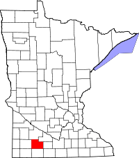 | |
| Townships | ||
| Unincorporated community | ||
| Footnotes | ‡This populated place also has portions in an adjacent county or counties | |
Coordinates: 43°51′59″N 95°07′01″W / 43.86639°N 95.11694°W