Westbrook, Minnesota
| Westbrook, Minnesota | |
|---|---|
| City | |
|
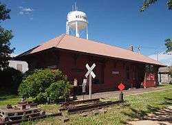
The old Westbrook Depot and water tower | |
 Location of Westbrook, Minnesota | |
| Coordinates: 44°2′33″N 95°26′12″W / 44.04250°N 95.43667°W | |
| Country | United States |
| State | Minnesota |
| County | Cottonwood |
| founded | Sept. 17, 1870 |
| Government | |
| • Type | Mayor – Council |
| • Mayor | Dennis Phelps |
| Area[1] | |
| • Total | 0.78 sq mi (2.02 km2) |
| • Land | 0.78 sq mi (2.02 km2) |
| • Water | 0 sq mi (0 km2) |
| Elevation | 1,427 ft (435 m) |
| Population (2010)[2] | |
| • Total | 739 |
| • Estimate (2015) | 726[3] |
| • Density | 947.4/sq mi (365.8/km2) |
| Time zone | Central (CST) (UTC-6) |
| • Summer (DST) | CDT (UTC-5) |
| ZIP code | 56183 |
| Area code(s) | 507 |
| FIPS code | 27-69250[4] |
| GNIS feature ID | 0654028[5] |
Westbrook is a city in Cottonwood County, Minnesota, United States. The population was 739 at the 2010 census.[6]
History
Westbrook was founded September 17, 1870. It was platted June 8th, 1900.[7] The city was named from its location near the west branch of Highwater Creek.[7][8]
Geography
According to the United States Census Bureau, the city has a total area of 0.78 square miles (2.02 km2), all land.[1]
Minnesota State Highway 30 serves as a main route in the community.
Demographics
| Historical population | |||
|---|---|---|---|
| Census | Pop. | %± | |
| 1910 | 429 | — | |
| 1920 | 654 | 52.4% | |
| 1930 | 610 | −6.7% | |
| 1940 | 871 | 42.8% | |
| 1950 | 1,017 | 16.8% | |
| 1960 | 1,012 | −0.5% | |
| 1970 | 990 | −2.2% | |
| 1980 | 978 | −1.2% | |
| 1990 | 853 | −12.8% | |
| 2000 | 755 | −11.5% | |
| 2010 | 739 | −2.1% | |
| Est. 2015 | 726 | [3] | −1.8% |
2010 census
As of the census[2] of 2010, there were 739 people, 345 households, and 192 families residing in the city. The population density was 947.4 inhabitants per square mile (365.8/km2). There were 418 housing units at an average density of 535.9 per square mile (206.9/km2). The racial makeup of the city was 97.7% White, 0.4% Native American, 0.9% Asian, 0.7% from other races, and 0.3% from two or more races. Hispanic or Latino of any race were 2.2% of the population.
There were 345 households of which 18.6% had children under the age of 18 living with them, 46.7% were married couples living together, 5.2% had a female householder with no husband present, 3.8% had a male householder with no wife present, and 44.3% were non-families. 40.9% of all households were made up of individuals and 23.4% had someone living alone who was 65 years of age or older. The average household size was 2.04 and the average family size was 2.71.
The median age in the city was 54 years. 18.7% of residents were under the age of 18; 4.8% were between the ages of 18 and 24; 17.6% were from 25 to 44; 25% were from 45 to 64; and 33.8% were 65 years of age or older. The gender makeup of the city was 44.2% male and 55.8% female.
2000 census
As of the census[4] of 2000, there were 755 people, 367 households, and 209 families residing in the city. The population density was 974.7 people per square mile (378.6/km²). There were 412 housing units at an average density of 531.9 per square mile (206.6/km²). The racial makeup of the city was 98.01% White, 0.13% African American, 0.40% Native American, 0.40% Asian, 0.13% from other races, and 0.93% from two or more races. Hispanic or Latino of any race were 0.66% of the population.
There are 367 households out of which 18.5% have children under the age of 18 living with them, 48.5% were married couples living together, 7.1% had a female householder with no husband present, and 42.8% were non-families. 39.8% of all households were made up of individuals and 28.3% had someone living alone who was 65 years of age or older. The average household size was 2.06 and the average family size was 2.74.
In the city the population was spread out with 20.5% under the age of 18, 4.4% from 18 to 24, 17.7% from 25 to 44, 21.9% from 45 to 64, and 35.5% who were 65 years of age or older. The median age was 52 years. For every 100 females there were 79.3 males. For every 100 females age 18 and over, there were 74.4 males.
The median income for a household in the city was $24,063, and the median income for a family was $33,472. Males had a median income of $27,188 versus $18,056 for females. The per capita income for the city was $15,919. 13.5% of the population and 8.5% of families were below the poverty line. Out of the total people living in poverty, 28.6% of those under the age of 18 and 9.1% of those 65 and older were living below the poverty line.
Sister City
Walnut Grove, Minnesota and Westbrook are sister cities because Westbrook-Walnut Grove (WWG) Public Schools is distributed between both towns.
Westbrook-Walnut Grove Public Schools
Starting with the 1991-1992 school year, the Westbrook Wildcats and the Walnut Grove Loggers combined school districts and sports teams to make the Westbrook-Walnut Grove Chargers.
WWG Information
- Schools - 1 High School in Westbrook (Grades 7–12) and one Elementary School in Walnut Grove (Grades K-6)
- Mascot - Chargers
- School Colors - Red and Silver
- ISD - 2898
Politics
Westbrook is located in Minnesota's 1st congressional district, represented by Mankato educator Tim Walz, a Democrat. At the state level, Westbrook is located in Senate District 22, represented by Republican Doug Magnus, and in House District 22B, represented by Republican Rod Hamilton.
Notable People
- Rocky Kolar, Longtime mayor of Westbrook
- William Richards, School Principal of the year winner
- Douglas J. Schmalz, Chief Financial Officer, Archer Daniels Midland Company.
- Thomas E. Patterson, Ph.D., Author and Bradlee Professor of Government and the Press, Kennedy School of Government, Harvard University
References
- 1 2 "US Gazetteer files 2010". United States Census Bureau. Retrieved 2012-11-13.
- 1 2 "American FactFinder". United States Census Bureau. Retrieved 2012-11-13.
- 1 2 "Annual Estimates of the Resident Population for Incorporated Places: April 1, 2010 to July 1, 2015". Retrieved July 2, 2016.
- 1 2 "American FactFinder". United States Census Bureau. Retrieved 2008-01-31.
- ↑ "US Board on Geographic Names". United States Geological Survey. 2007-10-25. Retrieved 2008-01-31.
- ↑ "2010 Census Redistricting Data (Public Law 94-171) Summary File". American FactFinder. United States Census Bureau. Retrieved 27 April 2011.
- 1 2 Upham, Warren (1920). Minnesota Geographic Names: Their Origin and Historic Significance. Minnesota Historical Society. p. 151.
- ↑ Chicago and North Western Railway Company (1908). A History of the Origin of the Place Names Connected with the Chicago & North Western and Chicago, St. Paul, Minneapolis & Omaha Railways. p. 196.
- ↑ "Census of Population and Housing". Census.gov. Retrieved June 4, 2015.
External links
Municipalities and communities of Cottonwood County, Minnesota, United States | ||
|---|---|---|
| Cities | 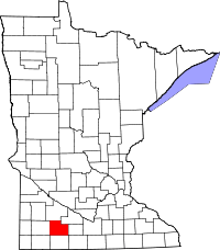 | |
| Townships | ||
| Unincorporated community | ||
| Footnotes | ‡This populated place also has portions in an adjacent county or counties | |
Coordinates: 44°02′32″N 95°26′10″W / 44.04222°N 95.43611°W