Yuba City, California
| City of Yuba City | |
|---|---|
| City | |
|
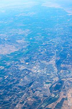
Yuba City, from the air | |
| Nickname(s): Prune Capital of the World | |
 Location in Sutter County and the state of California | |
 Yuba City Location in the United States | |
| Coordinates: 39°8′5″N 121°37′34″W / 39.13472°N 121.62611°WCoordinates: 39°8′5″N 121°37′34″W / 39.13472°N 121.62611°W | |
| Country | United States |
| State | California |
| County | Sutter |
| Incorporated | January 23, 1908[1] |
| Government | |
| • Type | Council-Manager |
| • Mayor | John Dukes[2] |
| Area[3] | |
| • Total | 14.656 sq mi (37.959 km2) |
| • Land | 14.578 sq mi (37.758 km2) |
| • Water | 0.078 sq mi (0.201 km2) 0.53% |
| Elevation[4] | 59 ft (18 m) |
| Population (April 1, 2010)[5] | |
| • Total | 64,925 |
| • Estimate (2013)[5] | 65,416 |
| • Density | 4,400/sq mi (1,700/km2) |
| Time zone | Pacific (UTC-8) |
| • Summer (DST) | PDT (UTC-7) |
| ZIP codes | 95991–95993[6] |
| Area code | 530 |
| FIPS code | 06-86972 |
| GNIS feature ID | 1660222 |
| Website |
www |
Yuba City is a city in Northern California and the county seat of Sutter County, California, United States. The population was 64,925 at the 2010 census.
Yuba City is the principal city of the Yuba City Metropolitan Statistical Area which encompasses all of Sutter County and Yuba County. The metro area's population is 164,138.[7][8] It is the 21st largest metropolitan area in California ranked behind Redding and Chico. Its metropolitan statistical area is part of the Greater Sacramento CSA.
The unemployment rate in the Yuba City MSA was 14.9 percent in September 2012, down from a revised 15.8 percent in August 2012, and below the year-ago estimate of 16.4 percent. This compares with an unadjusted unemployment rate of 9.7 percent for California and 7.6 percent for the nation during the same period. The unemployment rate was 14.0 percent in Sutter County, and 16.3 percent in Yuba County.
History
Early history
The Maidu people were settled in the region when they were first encountered by Spanish and Mexican scouting expeditions in the early 18th century. One version of the origin of the name "Yuba" is that during one of these expeditions, wild grapes were seen growing by a river, and so it was named "Uba", a variant spelling of the Spanish word uva (grape).
The Mexican government granted a large expanse of land which included the area in which Yuba City is situated to John Sutter, the same John Sutter upon whose land gold was subsequently discovered in 1848. He sold part of this tract to some enterprising men who wished to establish a town near the confluence of the Yuba River and the Feather River, tributaries of the Sacramento River, with an eye to developing a commercial center catering to the thousands of gold miners headed upstream to the gold fields. At the same time, another town was developing on the eastern bank of the Feather River, the beginnings of what later would become Marysville.
By 1852, Yuba City, was a steamboat landing, had one hotel, a grocery store, a post office, approximately 20 dwelling homes with a population of about 150.
The county seat for Sutter County, CA was chosen to be Yuba City in 1854. The same year, however, voters decided that Nicolaus would be a better location, and the county seat was moved there. County voters returned to their first choice of Yuba City two years later, in 1856, and it has remained the county seat since.[9]
Yuba City saw its first major influx of population after World War II, pushing residential areas west and south from the city's original center. Orchards were turned into residential areas as new homes were built for people migrating to the city.[10]
Flood of 1955
In December 1955, a series of storms dropped torrential rain throughout northern California. The deluge caused all the rivers in the region to overflow their banks and to break through levees. The Christmas Eve levee break at Yuba City was particularly disastrous, with 38 people losing their lives,[9] and heavy damage occurring in the downtown section. According to Dick Brandt, manager of the Yuba County airport in 1955, between 550 and 600 Sutter County residents were rescued from the floodwater by helicopter.[11]
B-52 airplane crash
On March 14, 1961, a Boeing B-52 Stratofortress carrying nuclear weapons, flying near Yuba City encountered a pressurization problem, and had to drop to a lower altitude. As such, more fuel than expected was used, and the aircraft ran out of fuel. It crashed before meeting with a tanker aircraft. The pilot gave the bailout command, and the crew egressed at 10,000 ft, except for the pilot, who ejected at 4,000 ft, while avoiding a populated area. The aircraft was destroyed. The weapons, two Mark 39 (3.8 megatons each) thermonuclear bombs (identified from declassified Department of Energy films and photographs) were destroyed on impact though no explosion took place, and there was no release of radioactive material as a result.[12]
1976 school bus crash
On May 21, 1976, a school bus carrying members of the Yuba City High School's choir to a performance at Miramonte High School in Orinda, California plunged 28 feet off the exit ramp on I-680 at Marina Vista Road in Martinez, California. Twenty-seven students and one adult chaperone died and twenty-three students were seriously injured.[13]
1994 mosque burning
Yuba City has been home to a significant Muslim population, including Pakistani Americans descended from c. 1902 immigrants. In 1994 the Muslim community completed a mosque that cost an estimated $1.8 million and many hours of donated work. Soon after, the mosque was destroyed by an act of arson, the first time that a hate crime destroyed a mosque in the United States. Eventually the mosque was rebuilt with help of Sikhs, Mormons, Christians, and other groups. The story is told in the 2012 documentary An American Mosque.
Geography
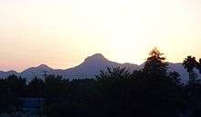
Yuba City is located at 39°8'5" North, 121°37'34" West (39.134792, −121.626201).[14] The Sutter Buttes are also the world's smallest mountain range.
According to the United States Census Bureau, the city has a total area of 14.7 square miles (38 km2), of which, 14.6 square miles (38 km2) of it is land and 0.1 square miles (0.26 km2) of it is water. The total area is 0.53% water.
The Yuba City area is located 40 miles north of Sacramento and situated in the Sacramento Valley. It is home to the Sutter Buttes, the smallest mountain range in the world.[15] The Feather River borders the city to the east and the area is sometimes referred to as the "Feather River Valley", which divides the city from its neighbor Marysville.
Climate
Yuba City has a hot-summer mediterranean climate (Csa according to the Köppen climate classification system) which consists of cool, wet winters and hot, dry summers. On average, January is the coolest and wettest month, and July is the hottest and driest. During the wet season from mid-October to mid-April, Yuba City sees frequent rain and is usually under the tule fog. Snow is rare in the valley, but cold waves from the north may bring some light snow and ice. Spring is wet in the beginning but becomes drier and warmer as summer months approach. May has some rain, but usually from thunderstorms, not winter storms. Rain is rare from June to September. The Delta Breeze, which comes from the Bay Area on summer nights, helps cool temperatures and adds humidity. At times the Delta Breeze is strong enough to bring coastal fog inland to the Sacramento Valley. Autumn starts out warm but becomes cooler, wetter, and foggier as the season progresses.
| Climate data for Yuba City, California. (Elevation 60ft) | |||||||||||||
|---|---|---|---|---|---|---|---|---|---|---|---|---|---|
| Month | Jan | Feb | Mar | Apr | May | Jun | Jul | Aug | Sep | Oct | Nov | Dec | Year |
| Record high °F (°C) | 75 (24) |
82 (28) |
90 (32) |
97 (36) |
106 (41) |
113 (45) |
111 (44) |
111 (44) |
113 (45) |
104 (40) |
90 (32) |
79 (26) |
113 (45) |
| Average high °F (°C) | 55 (13) |
61 (16) |
63 (17) |
70 (21) |
82 (28) |
91 (33) |
95 (35) |
93 (34) |
88 (31) |
75 (24) |
61 (16) |
54 (12) |
73 (23) |
| Average low °F (°C) | 37 (3) |
43 (6) |
45 (7) |
48 (9) |
54 (12) |
59 (15) |
61 (16) |
59 (15) |
55 (13) |
48 (9) |
41 (5) |
37 (3) |
48 (9) |
| Record low °F (°C) | 19 (−7) |
23 (−5) |
27 (−3) |
32 (0) |
37 (3) |
45 (7) |
45 (7) |
46 (8) |
43 (6) |
32 (0) |
27 (−3) |
18 (−8) |
18 (−8) |
| Average precipitation inches (mm) | 4.535 (115.2) |
4.126 (104.8) |
3.854 (97.9) |
1.705 (43.3) |
0.839 (21.3) |
0.291 (7.4) |
0.071 (1.8) |
0.079 (2.0) |
0.638 (16.2) |
1.425 (36.2) |
2.996 (76.1) |
3.673 (93.3) |
24.232 (615.5) |
| Source: weather.com | |||||||||||||
Demographics
| Historical population | |||
|---|---|---|---|
| Census | Pop. | %± | |
| 1890 | 562 | — | |
| 1910 | 1,160 | — | |
| 1920 | 1,708 | 47.2% | |
| 1930 | 3,605 | 111.1% | |
| 1940 | 4,968 | 37.8% | |
| 1950 | 7,861 | 58.2% | |
| 1960 | 11,507 | 46.4% | |
| 1970 | 13,986 | 21.5% | |
| 1980 | 18,736 | 34.0% | |
| 1990 | 27,437 | 46.4% | |
| 2000 | 36,758 | 34.0% | |
| 2010 | 64,925 | 76.6% | |
| Est. 2015 | 66,941 | [16] | 3.1% |
2010
The 2010 United States Census[18] reported that Yuba City had a population of 64,925. The population density was 4,429.9 people per square mile (1,710.4/km²). The racial makeup of Yuba City was 37,382 (57.6%) White, 1,591 (2.5%) African American, 909 (1.4%) Native American, 11,190 (17.2%) Asian, 228 (0.4%) Pacific Islander, 9,772 (15.1%) from other races, and 3,853 (5.9%) from two or more races. Hispanic or Latino of any race were 18,413 persons (28.4%).
The Census reported that 64,345 people (99.1% of the population) lived in households, 125 (0.2%) lived in non-institutionalized group quarters, and 455 (0.7%) were institutionalized.
There were 21,550 households, out of which 9,012 (41.8%) had children under the age of 18 living in them, 11,277 (52.3%) were opposite-sex married couples living together, 2,969 (13.8%) had a female householder with no husband present, 1,412 (6.6%) had a male householder with no wife present. There were 1,436 (6.7%) unmarried opposite-sex partnerships, and 118 (0.5%) same-sex married couples or partnerships. 4,753 households (22.1%) were made up of individuals and 1,960 (9.1%) had someone living alone who was 65 years of age or older. The average household size was 2.99. There were 15,658 families (72.7% of all households); the average family size was 3.49.
The population was spread out with 18,314 people (28.2%) under the age of 18, 6,630 people (10.2%) aged 18 to 24, 17,575 people (27.1%) aged 25 to 44, 14,810 people (22.8%) aged 45 to 64, and 7,596 people (11.7%) who were 65 years of age or older. The median age was 33.0 years. For every 100 females there were 97.9 males. For every 100 females age 18 and over, there were 95.3 males.
There were 23,174 housing units at an average density of 1,581.2 per square mile (610.5/km²), of which 12,266 (56.9%) were owner-occupied, and 9,284 (43.1%) were occupied by renters. The homeowner vacancy rate was 2.3%; the rental vacancy rate was 7.1%. 36,525 people (56.3% of the population) lived in owner-occupied housing units and 27,820 people (42.8%) lived in rental housing units.
2000
As of the census[19] of 2000, there are 36,758 people (60,507 as of January 1, 2006), 13,290 households, and 8,944 families residing in the city. The population density is 3,924.4 people per square mile (1,514.7/km²). There are 13,912 housing units at an average density of 1,485.3 per square mile (573.3/km²). The racial makeup of the city is 67.0% White, 2.8% African American, 1.7% Native American, 6.4% Asian American, 0.3% Pacific Islander, 14.4% from other races, and 2.4% from two or more races.[20] 12.5% of the population are Hispanic or Latino of any race. The European population in Yuba City is 0.5% Romanian, 0.3% Italian, and 1.6% German.
There are 13,290 households out of which 36.7% have children under the age of 18 living with them, 47.6% are married couples living together, 14.3% have a female householder with no husband present, and 32.7% are "non-families." 26.5% of all households are made up of individuals and 9.7% have someone living alone who is 65 years of age or older. The average household size is 2.70 and the average family size is 3.28.
In the city the population is spread out with 29.0% under the age of 18, 10.7% from 18 to 24, 29.4% from 25 to 44, 18.7% from 45 to 64, and 12.2% who are 65 years of age or older. The median age is 32 years. For every 100 females there are 95.5 males. For every 100 females age 18 and over, there are 91.7 males.
The median income for a household in the city is $32,858, and the median income for a family is $39,381. Males have a median income of $34,303 versus $23,410 for females. The per capita income for the city is $15,928. 18.1% of the population and 14.5% of families are below the poverty line. Out of the total population, 24.8% of those under the age of 18 and 9.5% of those 65 and older are living below the poverty line.
Transportation
Bus service in Yuba City is provided by Yuba Sutter Transit.
The city is served by two highways. California State Route 20 is the major east-west route, running to Marysville to the east, and Williams to the west. California State Route 99 travels south toward Sacramento, and north to Chico
Business and economy
Sunsweet Growers Inc. headquarters
Yuba City is home to the largest dried fruit processing plant in the world,[21] Sunsweet Growers Incorporated. In 1988 Yuba City was home to the California Prune Festival. In 2001 the name was changed to the California Dried Plum Festival and in early 2003 directors announced the end of the festival's 15-year run in the Yuba-Sutter area. This was primarily due to rise in costs, difficulty in securing sponsors, and competition from other festivals.
Other employers
Being a small town, retail and healthcare make up the largest sectors of the economy.[22] Some other notable employers include the Geweke Auto Group, Hilbers Incorporated, SharpeSoft, Jaeger Construction and Nordic Industries, Inc. Farming is also the most important part of the Yuba-Sutter area.
Top employers
According to the City's 2014 Comprehensive Annual Financial Report,[23] the top employers in the city are:
| # | Employer | # of Employees |
|---|---|---|
| 1 | Fremont-Rideout Health Group | 1,855 |
| 2 | Yuba City Unified School District | 1,377 |
| 3 | Sutter County | 857 |
| 4 | Sunsweet Growers | 710 |
| 5 | Walmart | 550 |
| 6 | Sutter North Medical Group | 450 |
| 7 | City of Yuba City | 297 |
| 8 | Sam's Club | 240 |
| 9 | Target | 200 |
| 10 | Raley's/Bel Air | 180 |
Arts and culture
Annual events
Sikh Parade
Yuba City is known for its sizeable Sikh community.[24][25] The Sikh population in the Yuba-Sutter Area has grown to be one of the largest in the United States and one of the largest Sikh populations outside of the Punjab state of India. Each year on the first Sunday of November, Sikhs from the United States, Canada, India, the United Kingdom and throughout the world attend the Sikh parade in Yuba City, which commemorates the receipt by Sikhs of their Holy scripture, the Guru Granth Sahib, in 1708. The 4.5-mile-long parade features floats and a procession of parade participants. The 2005 parade drew an estimated 56,000 people while the 2007 parade was estimated to draw between 75,000 and 85,000 people of both Sikh and non-Sikh background. In 2008, an estimated 80,000 people came out for the event which is now considered one of the largest gatherings in Northern California.[26] In 2012, the parade participants rose to an estimated number of 150,000 people.
California Swan Festival
November 13–15, Caltrans Building
Museums and other points of interest
Government
In the California State Legislature, Yuba City is in the 4th Senate District, represented by Republican Jim Nielsen, and in the 3rd Assembly District, represented by Republican James Gallagher.[27]
In the United States House of Representatives, Yuba City is in California's 3rd congressional district, represented by Democrat John Garamendi.[28]
Yuba City also has the first Sikh American Mayor.
Parks
Community parks:
- Sam Brannan Park
- Blackburn-Talley Sports Complex/Park
- Gauche Aquatic Park
Neighborhood parks:
- Bogue Park
- Greenwood Park
- Happy Park
- Hillcrest Park
- Holly Tree Park
- Kingwood Park
- Lloyd Park
- Maple Park
- Moore Park
- Nakwhal Park
- Northridge Park
- Patriot Park
- Regency Park
- Shanghai Garden Park
- Southside Park
Passive parks:
- Clark-Ainsley Mini Park
- Plumas Tower Plaza Mini Park
- Veterans Memorial Park
Other recreational facilities:
- April Lane School/Park
- Geweke Field
- City Hall
- Senior Center
- Feather River Levee Bike Trail
- AK School/AKMS
Education

Public schools are part of the Yuba City Unified School District.[29] The three high schools in the district are Yuba City High School, River Valley High School, and Albert Powell Continuation High School. Faith Christian High School, Grace Christian Academy, and Adventist Christian School (http://www.acselementary.org) are private christian schools located in Yuba City. The Yuba City Charter School is K-12. Twin Rivers Charter is a K-8. St. Isidore Catholic School is a PK-8 parochial school under the auspices of St. Isidore Catholic Church.
Yuba City is in the Yuba Community College District and is served by Yuba Community College in neighboring Marysville.
Media
The main newspaper for Yuba City area is the Appeal-Democrat. The newspaper is printed in Marysville, but serves the entire Yuba-Sutter area. The Sacramento Bee is also widely sold and read in Yuba City.
Although KETQ-LP 93Q, KUBA, KCYC-LP, KOBO, and KRYC-LP are the only radio stations within the city, there are a wide variety of others broadcasting nearby.
Notable people
- Frank Bacon, actor
- Guy Branum, actor, comedian, podcaster, and writer
- Richard Buckner, singer-songwriter
- Juan Corona, murderer
- Marcie Dodd, singer and actress
- Wally Herger, politician, member of U.S. House of Representatives 1987–2012
- Brad Johnson, actor and real estate developer
- Leanne Marshall, winner of Season 5 of Project Runway
- John Joseph Montgomery, aviation pioneer, was born in Yuba City
- Michael P. Moran, actor and screenplay writer
- Charlie Peacock, award-winning songwriter, recording artist, record producer – born Charles W. Ashworth
- Chris Petersen, University of Washington head football coach
- Darryl Scott, Los Angeles Angels pitcher
- Max Stassi, Houston Astros catcher
- Charlotte Stewart, actress
Sister cities
-
 – Toride, Ibaraki, Japan as determined by Sister Cities International.[30]
See also
References
- ↑ "California Cities by Incorporation Date" (Word). California Association of Local Agency Formation Commissions. Retrieved August 25, 2014.
- ↑ "City Council". Yuba City, CA. Retrieved January 11, 2015.
- ↑ "2010 Census U.S. Gazetteer Files – Places – California". United States Census Bureau.
- ↑ "Yuba City". Geographic Names Information System. United States Geological Survey. Retrieved November 9, 2014.
- 1 2 "Yuba City (city) QuickFacts". United States Census Bureau. Retrieved March 11, 2015.
- ↑ "ZIP Code(tm) Lookup". United States Postal Service. Retrieved November 9, 2014.
- ↑ Yuba County 2007 Census Estimate
- ↑ Sutter County 2007 Census Estimate
- 1 2 "History of Yuba City". Retrieved October 11, 2008.
- ↑ "Yuba City At A Glance" (PDF). Retrieved October 11, 2008.
- ↑ View a 1955 KRON-TV special report featuring the flooding in Yuba City & Marysville: https://diva.sfsu.edu/collections/sfbatv/bundles/191491.
- ↑ Maggelet, Michael H.; James C. Oskins (2008). Broken Arrow – The Declassified History of U.S. Nuclear Weapons Accidents. Lulu.com. ISBN 978-1-4357-0361-2.
- ↑ Kulczyk, David. (2009). Death In California – The Bizarre, Freakish, and Just Curious Ways People Die in the Golden State. Craven Street Books. P121 ISBN 978-1-884995-57-6
- ↑ "US Gazetteer files: 2010, 2000, and 1990". United States Census Bureau. 2011-02-12. Retrieved 2011-04-23.
- ↑ Sutter Buttes
- ↑ "Annual Estimates of the Resident Population for Incorporated Places: April 1, 2010 to July 1, 2015". Retrieved July 2, 2016.
- ↑ "Census of Population and Housing". Census.gov. Retrieved June 4, 2015.
- ↑ "2010 Census Interactive Population Search: CA – Yuba City city". U.S. Census Bureau. Retrieved July 12, 2014.
- ↑ "American FactFinder". United States Census Bureau. Retrieved 2008-01-31.
- ↑ American FactFinder
- ↑ Sunsweet Growers
- ↑ http://www.city-data.com/business/econ-Yuba-City-California.html Yuba City at City-Data.com
- ↑ City of Yuba City CAFR
- ↑ "Sikh". Topix. Retrieved December 16, 2015.
- ↑ "The Sunday Tribune – Spectrum". Retrieved December 16, 2015.
- ↑ Sikh Heritage Celebrated
- ↑ "Statewide Database". UC Regents. Retrieved November 20, 2014.
- ↑ "California's 3rd Congressional District - Representatives & District Map". Civic Impulse, LLC. Retrieved March 1, 2013.
- ↑ "Home – Yuba City Unified School District". Retrieved December 16, 2015.
- ↑ "Sister Cities International Directory: California, USA". Retrieved October 16, 2008.
External links
| Wikimedia Commons has media related to Yuba City, California. |
- Official website
- Yuba City Police Department
- Punjabi American Heritage Society of Yuba City
- Yuba City on the Yuba-Sutter local wiki
 |
Live Oak | | ||
| Tierra Buena | |
Marysville Linda | ||
| ||||
| | ||||
| South Yuba City | Sacramento, California | Olivehurst, California |
Municipalities and communities of Sutter County, California, United States | ||
|---|---|---|
| Cities | 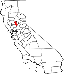 | |
| CDPs | ||
| Unincorporated communities | ||