Zakarpattia Oblast

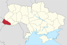
The Zakarpattia Oblast (Ukrainian: Закарпатська область, translit. Zakarpats’ka oblast’; see other languages) is an administrative oblast (province) located in southwestern Ukraine, coterminous with the historical region of Carpathian Ruthenia. Its administrative centre is the city of Uzhhorod. Other major cities within the oblast include Mukachevo, Khust, Berehove and Chop which is home to railroad transport infrastructure.
Zakarpattia Oblast was established on 22 January 1946, after Czechoslovakia ceded the territory of Subcarpathian Rus to the Ukrainian Soviet Socialist Republic, under a treaty between Czechoslovakia and the Soviet Union. Some scholars say that during the Ukrainian independence referendum held in 1991, Zakarpattia Oblast voters were given a separate option on whether or not they favoured autonomy for the region.[3] Although a large majority favoured autonomy, it was not granted.[3] However, this referendum was about self-government status, not about autonomy (like in Crimea).[4]
Situated in the Carpathian Mountains of western Ukraine, Zakarpattia Oblast is the only Ukrainian administrative division which borders upon four countries: Poland, Slovakia, Hungary and Romania. The Carpathian Mountains play a major part in the oblast's economy, making the region an important tourist and travel destination housing many ski and spa resorts.
With its almost 13,000 square kilometres (5,000 sq mi), the oblast is ranked 23rd by area and 15th by population as according to the 2001 Ukrainian Census, the population of Zakarpattia Oblast is 1,254,614. This total includes people of many different nationalities of which Hungarians, Romanians and Rusyns constitute significant minorities in some of the province's cities, while in others, they form the majority of the population (as in the case of Berehove).
Name
The oblast is also referred to as the Transcarpathian Oblast, Transcarpathia, Zakarpattya, or historically as Subcarpathian Rus. In other languages the oblast is named:
- Rusyn: Подкарпатьска област, translit. Podkarpat’ska oblast.
- Hungarian: Kárpátalja
- Czech: Podkarpatská Rus
- Slovak: Zakarpatská oblasť
- Polish: Obwód zakarpacki
- Romanian: Maramureșul de Nord or Regiunea Transcarpatia pronounced [red͡ʒiˈune̯a subkarˈpat͡i.a]
- Russian: Закарпатская область, translit. Zakarpatskaya oblast
While the name Transcarpathia is a translation of the Ukrainian version of the name, the Hungarian name translates as Subcarpathia, following the Hungarian language logic "feet of the mountains", naming a territory after its geographic location at the lower section of a mountain range. (Following the same language pattern that applies to the name of the sub-Alpian territory in Western Hungary, Alpokalja)[5]
Generally, the Transcarpathia name and its versions reflect the East Slavic language logic, while some Western languages follow the same logic as the Hungarian:[6]
- English: Subcarpathia, Subcarpathian Russia, Subcarpathian Ruthenia, Sub-Carpathian Ukraine
- French: Ukraine Subcarpathique, Russie subcarpathique
Other Western languages follow their own logic in creating a name for the region:
- German: Karpatenrussland, Karpatenland, Karpathenland, Karpatho-Russland, Karpatenukraine, Karpato-Ukraine
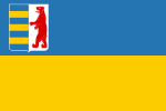
The coat of arms of Zakarpattia was originally created in the end of the 1910s in the then Czechoslovakia.
Geography
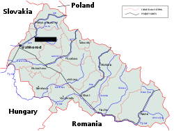
The Zakarpattia Oblast has a total area of 12,800 km2 (4,942 sq mi) and is located on southwestern slopes and foothills of the Carpathian Mountains covering around 80% of area in the region.[7] The rest of the region is covered by the Transcarpathian Lowland which is part of the Pannonian plain. Zakarpattia is the only Ukrainian oblast to have boundaries with four countries: Poland, Slovakia, Hungary and Romania.[8] On the West it borders the Prešov and Košice Regions of Slovakia and Borsod-Abaúj-Zemplén and Szabolcs-Szatmár-Bereg Counties of Hungary, on the South—the Satu Mare and Maramureş Counties of Romania, on the East and Northeast—Ivano-Frankivsk Oblast, and on the North—Lviv Oblast and the Subcarpathian Voivodeship of Poland.
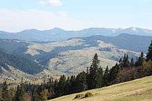
The Zakarpattia Oblast mostly consists of mountains and small hills covered with deciduous and coniferous forests, as well as alpine meadows. Mountains cover about 80% of the oblast's area, and cross from North-East to South-East.[9] The Primeval Beech Forests of the Carpathians, part of which are located within Zakarpattia Oblast, were recognized as a UNESCO World Heritage Site in 2007.[10]
The largest rivers that flow through the oblast include the Tysa, Borzhava, and the Tereblia. A high altitude lake is located in Rakhiv Raion, which is the highest in the region. It is called Nesamovyte.[11] The lake is located in the Hoverla preserve on the slopes of Turkul mountain. The lake's area is 3,000 square metres (32,000 sq ft) and it is located 1,750 metres (5,740 ft) above sea level.
The region's climate is moderate and continental[7] with about 700–1,000 mm (28–39 in) of rainfall per year.[8] The average temperature in summer is +21 °С (70 °F) and −4 °С (25 °F) in winter.[7] With an elevation of 2,061 metres (6,762 ft) above sea level, Hoverla, part of the Chornohora mountain range, is the highest point in the oblast.[7] The lowest point, 101 m (331 ft) above sea level, is located in the village of Ruski Heyevtsi (Oroszgejőc in Hungarian) in the Uzhhorodskyi Raion.[9]
Four of the oblast's historical-cultural sites were nominated for the Seven Wonders of Ukraine competition in 2007: Palanok Castle, Museum upon the Chorna River, Mykhailiv Orthodox Church, and the Nevytsky Castle.
History
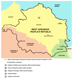
The lands of Transcarpathia were part of the Kingdom of Hungary since 896. As such, it formed part of Austria-Hungary until the latter's demise at the end of World War I. It approximately consists of four Hungarian counties (comitatus): Bereg, Ung, Ugocsa and Maramaros. This region was briefly part of the short-lived West Ukrainian National Republic in 1918. The region was annexed by Romania by the end of that year, mostly the eastern portion such as Rakhiv and Khust. It was later recaptured by Hungarian Soviet Republic in the summer of 1919. Finally, under the name Subcarpathian Rus (Czech: Podkarpatská Rus), after the Paris Peace Conference of 1919 it was annexed to Czechoslovakia with a supposedly equal level of autonomy as Slovakia and Bohemia-Moravia-Czech Silesia (Czech lands).[12] Nevertheless, such autonomy was granted as late as in 1938, after detrimental events of the Munich Conference; until then this land was administered directly from Prague by the government-appointed provincial presidents (zemští prezidenti) and/or elected governors (guvernéři).
The province has a unique footnote in history as the only region in the former Czechoslovakia to have had an American governor: its first governor was Gregory Zatkovich, an American citizen who had earlier emigrated from the region and represented the Rusyn community in the U.S. Zatkovich was appointed governor by Czechoslovakia's first president, T. G. Masaryk in 1920, and served for about one year until he resigned over differences regarding the region's autonomy.
During the World War II German occupation of Czechoslovakia, the southern part of the region was awarded to Hungary under the First Vienna Award in 1938. The remaining portion was constituted as an autonomous region of the short-lived Second Czechoslovak Republic. After the occupation of Bohemia and Moravia on March 15, 1939 and the Slovak declaration of an independent state, Carpathian Ruthenia declared its independence as the Republic of Carpatho-Ukraine, but was immediately occupied and later annexed by Hungary. [13] Because it only existed on March 15th 1939 the state is known as 'the one-day republic'

The major Jewish communities of the region had existed in Munkachevo, Ungvar, and Khust. During the German occupation of Hungary [March 1944-December 1944] , almost the entire Jewish population was deported; few survived the Holocaust.[14] In October 1944 the Sub-Carpathian Ukraine was occupied by the Red Army. In June 29, 1945, Czechoslovak President Edvard Beneš signed a treaty ceding the area and the next month it was united with the Ukrainian SSR through the "Manifest for unification with the Soviet Ukraine" that was accepted by the 1st Congress of People's Committees of Sub-Carpathian Ukraine without any knowledge of common people. It was then annexed into the Ukrainian SSR as Zakarpattia Oblast.[14] After the break-up of the Soviet Union, it became part of independent Ukraine.
After the fall of the Soviet Union in 1991, Ukraine held an independence referendum in which the residents of Zakarpattia were asked about the Zakarpattia Oblast Council's proposal for self-rule.[3] About 78% of the oblast's population voted in favour of autonomy; however, it was not granted.[3] There were also propositions of separating from Ukraine to rejoin Czechoslovakia,[15] but after Czechoslovakia's dissolution into the Czech Republic and the Slovak Republic (1993), these ideas have been rendered largely moot.
On October 25, 2008, delegates to the Congress of Carpathian Ruthenians declared the formation of the Republic of Carpathian Ruthenia.[16] The prosecutor’s office of Zakarpattia region has filed a case against Russian Orthodox Church priest[17] Dmytro Sidor and Yevhen Zhupan, an Our Ukraine party deputy of the Zakarpattia regional council and chairman of the People’s Council of Ruthenians, on charges of encroaching on the territorial integrity and inviolability of Ukraine.[18]
Politics
Zakarpattia Oblast's local administration is controlled by the Zakarpattia Oblast Council (rada).
The oblast's governor (currently Oleksandr Ledyda[19][20]) is appointed by the President of Ukraine.
Administrative divisions

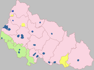
Zakarpattia Oblast is administratively subdivided into 13 raions (districts), as well as 5 cities (municipalities) which are directly subordinate to the oblast government: Berehove, Chop, Khust, Mukachevo, and the administrative centre of the oblast, Uzhhorod. There are a total of 7 cities, 19 towns, and more than 579 villages.
Zakarpattia Oblast incorporates four unofficial geographic-historic regions (counties): Ung, Bereg, Ugocsa and Northern Maramuresh. There is a project for a reform of the current administrative division of the Oblast[21]
The oblast (region) is divided into 13 raions and five cities of regional importance including the administrative centre Uzhhorod. Administrative centres of raions may be located within a city of regional importance, while such city is not technically a part of the raion. A city of regional significance may consists of an individual populated place or be complex of several settlements (the city proper and suburbs) which are governed by own radas (councils).
Further each raion divided into radas (councils). Cities and towns (urban type settlements) all have own individual councils, while villages and rural settlements may be formed into multiple settlements councils or an individual village council. All cities are either of regional importance or of district importance.
Raions
There are 13 raions (districts) in the oblast:
- Berehove Raion (54,062) w/o Berehove city
- Irshava Raion (100,905)
- Khust Raion (96,960) w/o Khust city
- Mizhhiria Raion (49,890)
- Mukachevo Raion (101.443) w/o Mukacheve city
- Perechyn Raion (32,026)
- Rakhiv Raion (90,945)
- Svaliava Raion (54,869)
- Tiachiv Raion (171,850)
- Uzhhorod Raion (74,399) w/o Uzhhorod city and Chop city
- Velykyy Bereznyi Raion (28,211)
- Volovets Raion (25,474)
- Vynohradiv Raion (117,957)
Urban settlements
| Largest cities or towns in Zakarpattia Oblast Source? | |||||||||
|---|---|---|---|---|---|---|---|---|---|
| Rank | Raion | Pop. | |||||||
 Uzhhorod  Mukacheve |
1 | Uzhhorod | Uzhhorod* | 115,520 | 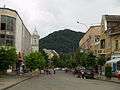 Khust  Vynohradiv | ||||
| 2 | Mukacheve | Mukacheve* | 86,061 | ||||||
| 3 | Khust | Khust* | 28,643 | ||||||
| 4 | Vynohradiv | Vynohradiv | 25,565 | ||||||
| 5 | Berehove | Berehove* | 24,458 | ||||||
| 6 | Svaliava | Svaliava | 17,027 | ||||||
| 7 | Rakhiv | Rakhiv | 15,243 | ||||||
| 8 | Dubove | Tiachiv | 9,775 | ||||||
| 9 | Mizhhirya | Mizhhirya | 9,616 | ||||||
| 10 | Korolevo | Vynohradiv | 9,339 | ||||||
Cities of regional significance
- Uzhhorod (116,400)
- Mukachevo (93,738)
- Khust (31,083)
- Berehove (Beregszász) (24,274)
- Chop (Csap) (8,436)
Other urban settlements
- Vynohradiv (Nagyszőlős) (27,600)
- Rakhiv (Rahó) (17,000)
- Svaliava (16,217)
- Tiachiv (Técső) (9,256)
- Mizhhiria (9,133)
- Irshava (9,000)
- Velykyy Bychkiv (8,920)
- Solotvyno (Slatina, Aknaszlatina) (8,774)
- Dubove (8,745)
- Velyki Luchky (8,540)
- Ilnytsia (8,420)
- Bushtyno (8,091)
Demographics
According to the 2001 Ukrainian Census, the population of Zakarpattia Oblast is 1,254,614.[22] The current estimated population is 1,259,158 (2016 est.)[23]. With the comparison of the last official Soviet Census of 1989 the total population grew by 0.7%.
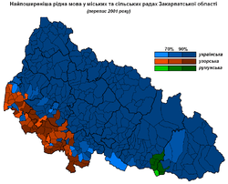
Although Ukrainians, including ethnic Rusyns (1%), are in the majority (80.5%),[24] other ethnic groups are relatively numerous in Zakarpattia. The largest of these are Hungarians (12.1%), Romanians (2.6%), Russians (2.5%), Roma (1.1%), Slovaks (0.5%) and Germans (0.3%).[24] The Ukrainian government does not recognize the Rusyn people living in that country as a distinct nationality but rather as an ethnic sub-group of Ukrainians. About 10,100 people (0.8%) identify themselves as Rusyns according to the last census.[25]
Out of 1,010,100 Ukrainians in the region, 99.2% (~1,002,019) identified their native language as Ukrainian, while about 0.5% (~5,051) consider their native language to be Russian. Out of 151,500 Hungarians, 97.1% (~147,107) consider their native language to be Hungarian, while about 2.6% (~3,939) consider their native language to be Ukrainian. Out of 32,100 Romanians, 99.1% (31,811) identified their native language to be Romanian, while 0.6% (~193) consider their language Ukrainian. Out of 31,000 Russians, 91.6% (28,396) identified their native language as Russian, while 8.1% (~2,511) consider their language Ukrainian. Out of 14,000 Romani peoples only 20.7% (2,898) identify their native language as Romani, while 62.9% (~8,806) consider their language Ukrainian or Russian. Out of 5,600 Slovaks 43.9% (2,458) identify their native language as Slovak, while 42.1% (~2,358) consider their language Ukrainian. Out of 3,500 Germans, 50.0% (1,750) acknowledge their native language, while 38.9% (~1,362) consider their language Ukrainian. About 81% of the oblast population considers the Ukrainian language their native language, while 12.7% of population gives consideration to the Hungarian language and just over 5% considers either the Russian or Romanian languages.
The largest denomination is the Ruthenian Catholic Church; the oblast's territory forms the church's Eparchy of Mukachevo; with 380,000 faithful, it has a solid majority of the oblast's churchgoers. Other smaller groups include Roman Catholics, Protestants, and Orthodox, which are largely associated with minority groups; Roman Catholics and Protestants tend to be Hungarian or local Ruthenian, while the Eastern Orthodox are usually Romanians, Russians or Ukrainians from further east.
| Nationality | Number | in 2001 (%) | in 1989 (%) | growth (%) |
|---|---|---|---|---|
| Ukrainians (incl. Rusyns) | 1,010,100 | 80.5 | 78.4 | +3.4% |
| Hungarians | 151,500 | 12.1 | 12.5 | -2.7% |
| Romanians | 32,100 | 2.6 | 2.4 | +9.0% |
| Russians | 31,000 | 2.5 | 4.0 | -37.3% |
| Roma | 14,000 | 1.1 | 1.0 | +15.4% |
| Slovaks | 5,600 | 0.5 | 0.6 | -22.3% |
| Germans | 3,500 | 0.3 | 0.3 | +3.0% |
| Year | Fertility | Birth | Year | Fertility | Birth | Year | Fertility | Birth |
|---|---|---|---|---|---|---|---|---|
| 1990 | 2,2 | 21 251 | 2000 | 1,5 | 14 481 | 2010 | 1,9 | 18 301 |
| 1991 | 2,2 | 21 059 | 2001 | 1,4 | 13 699 | 2011 | 1,9 | 18 460 |
| 1992 | 2,2 | 20 559 | 2002 | 1,5 | 14 207 | |||
| 1993 | 2,0 | 19 264 | 2003 | 1,5 | 14 747 | |||
| 1994 | 1,9 | 17 725 | 2004 | 1,5 | 15 472 | |||
| 1995 | 1,8 | 17 320 | 2005 | 1,6 | 15 750 | |||
| 1996 | 1,7 | 16 473 | 2006 | 1,7 | 16 530 | |||
| 1997 | 1,6 | 15 708 | 2007 | 1,7 | 16 833 | |||
Their languages and culture are respected by the provision of education, clubs, etc. in their respective languages. Those who recognize Ukrainian as their native language total 81.0% of the population, Hungarian — 12.7%, Russian — 2.9%, Romanian — 2.6%,[22] and Rusyn — 0.5%[26] Residents in seven of Mukachivskyi Raion's villages have the option to learn the Hungarian language in a school or home school environment.[2]
Zakarpattia is home to approximately 14,000 ethnic Roma (Gypsies), the highest proportion of Roma in any oblast in Ukraine. The first Hungarian College in Ukraine is in Berehovo, the II. Rákoczi Ferenc College.
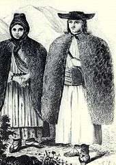
Beside the major ethnic groups, Zakarpattia is home to several Ukrainian ethnic sub-groups such as Boykos, Lemky, Hutsuls, and others.
Age structure
- 0-14 years: 19.1%
 (male 123,009/female 116,213)
 - 15-64 years: 69.8%
 (male 428,295/female 445,417)
 - 65 years and over: 11.1% (male 48,826/female 89,800) (2013 official)
Median age
- total: 35.1 years
- male: 33.2 years
- female: 37.1 years (2013 official)
Economy
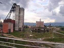
Situated in the Carpathian Mountains, Zakarpattia Oblast's economy depends mostly on trans-border trade, vinery and forestry. The oblast is also home to a special economic zone.[27][28]
The oblast's main industry includes woodworking. Other industries include food, light industry, and mechanical engineering. The foodstuffs segment in the structure of ware production of national consumption is 45%. The total number of large industrial organisations is 319, compared to 733 small industrial organisations.[8]
The most common crops grown within the region include cereals, potatoes and other vegetables. In 1999, the total amount of grain produced was 175,800 tons, of sunflower seeds — 1,300 tons, and potatoes — 378,200 tons.[8] The region also produced 76,100 tons of meat, 363,400 tons of milk and 241,900,000 eggs.[8] The total amount of registered farms in the region was 1,400 in 1999.[8]
Culture
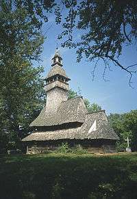
Wooden churches
- Sredne Vodyane churches
- Verkhnye Vodyane church
- Danylovo church
- Kolodne church
- Krainykovo church
- Nyzhnie Selyshche church
- Oleksandrivka church
- Sokyrnytsia church
See also
- Carpathian Ruthenia, small historical region
- Carpatho-Ukraine, a short-lived Ukrainian state on the territory
- Ruthenians and Ukrainians in Czechoslovakia
- Museum of Folk Architecture and Life, museum displaying Zakarpattia architecture
References
- Notes
- ↑ Poroshenko appoints volunteer Heorhiy Tuka head of Luhansk Regional State Administration, Ukraine Today (22 July 2015)
- 1 2 "Mukachivskyi Raion: Social data". Zakarpattia Oblast Administration. Retrieved 2007-06-02.
- 1 2 3 4 Magocsi, Paul Robert (2007). Ukraine: An Illustrated History. Seattle: University of Washington Press. ISBN 0-295-98723-5.
- ↑ Kuzio, Taras. "The Rusyn Question in Ukraine: sorting out fact from fiction". Canadian Review of Studies in Nationalism. XXXII (2005).
- ↑ "The name "Kárpátalja", as it appears on the cover of the journal of the Transcarpathian section of the Hungarian Writers' Union" (PDF). Retrieved 2014-03-02.
- ↑ "Christian Pischlöger: Kárpátalja vagy Kárpátontúl? College of Nyíregyháza" (PDF). Retrieved 2014-03-02.
- 1 2 3 4 "Geography". Zakarpattia Oblast Council (in Ukrainian). Retrieved 2007-11-18.
- 1 2 3 4 5 6 "Zakarpattya Region". Cabinet of Ministers of Ukraine. Retrieved 2007-06-01.
- 1 2 "Transcarpathia is my region". All Zakarpattya. Retrieved 2007-06-01.
- ↑ "Primeval Beech Forests of the Carpathians". UNESCO World Heritage Centre. Retrieved 2007-07-04.
- ↑ Nesamovyte Lake profile (Russian)
- ↑ Subtelny, Orest (2000). Ukraine: A History. University of Toronto Press. p. 448. ISBN 0-8020-8390-0.
- ↑ Subtelny, p. 458
- 1 2 "History of the region". All Zakarpattya. Retrieved 2007-06-01.
- ↑ Subtelny, p. 578
- ↑ "Svoboda Party Calls On SBU To Launch Criminal Case Against Delegates To Congress Of Carpathian Ruthenians For Declaring Carpathian Ruthenia Republic". Retrieved 2008-11-06.
- ↑ Is Yushchenko’s Top Aide Backing Ruthenian Separatist Movement?, The Jamestown Foundation, 5 November 2008
- ↑ "Prosecutors File Case Against People Who Initiated Proclamation Of Carpathian Ruthenian Republic On Separatism Charges". Retrieved 2008-11-06. (broken link)
- ↑ The governing body of the Regional State Administration, Zakarpattia Oblast official website
- ↑ President appoints 14 regional governors, Interfax-Ukraine (March 18, 2010)
- ↑ Admin. div. reform (Ukrainian)
- 1 2 "Regions of Ukraine / Zakarpattia region". 2001 Ukrainian Census. Retrieved 2007-06-01.
- ↑ "Чисельність наявного населення України (Actual population of Ukraine)" (PDF) (in Ukrainian). State Statistics Service of Ukraine. Retrieved 19 July 2016.
- 1 2 "General results of the census / National composition of population / Zakarpattia region". 2001 Ukrainian Census. Retrieved 2013-01-28.
- ↑ "General results of the census / National composition of population / Zakarpattia region". 2001 Ukrainian Census (in Ukrainian). Retrieved 2007-06-03.
- ↑ "Regions of Ukraine / Results of the census". 2001 Ukrainian Census (in Ukrainian). Retrieved 2007-06-03.
- ↑ "History of the Region". World Gazetteer. Retrieved 2007-06-01.
- ↑ Laws of Ukraine. Verkhovna Rada law No. 2322-III: On the official economic zone of "Zakarpattia". Adopted on 2004-03-31. (Ukrainian)
External links
| Wikimedia Commons has media related to Zakarpattia Oblast. |
- carpathia.gov.ua — Official website of Zakarpattia Oblast Administration (Ukrainian)/(English)
- Zakarpattia Council official site (Ukrainian)
- Zaholovok — Zakarpattia actual news(Ukrainian)
- Zakarpattia essays — All about Zakarpattia and Ukraine
- Verkhovna Rada website — Zakarpattia Oblast data
- Photos and infrastructure objects of Zakarpattia on interactive map (Ukrainian Navigational Portal)
- News from Zakarpattia (Ukrainian)
- all.zakarpattya.net — All about Zakarpattia (English)/(Ukrainian)
- mukachevo.net — Zakarpattia Oblast informational portal (Ukrainian)
- map.meta.ua — Digital map of Zakarpattia Oblast (Ukrainian)
- Zakarpattia Oblast – photographs
- Dictionary of transcarpathian words (Ukrainian)
 |
Prešov Region |
Podkarpackie Voivodeship |
Lviv Oblast / Ivano-Frankivsk Oblast | |
| Košice Region |
|
Ivano-Frankivsk Oblast | ||
| ||||
| | ||||
| Szabolcs-Szatmár-Bereg County |
Satu Mare County |
Maramureș County |
| Raions | |||||||
|---|---|---|---|---|---|---|---|
| Cities |
| ||||||
| |||||||
| Timeline of Czechoslovak statehood | ||||||||||
|---|---|---|---|---|---|---|---|---|---|---|
| Pre-1918 | 1918–1938 | 1938–1945 | 1945–1948 | 1948–1989 | 1989–1992 | 1993– | ||||
| Bohemia Moravia Silesia |
Austrian Empire | First Republica | Sudetenlandb | Third Republic | Czechoslovak Republice 1948–1960 |
Czechoslovak Socialist Republicf 1960–1990 |
Czech and Slovak Federative Republic 1990–1992 |
Czech Republic | ||
| Second Republicc 1938–1939 |
Protectorate of Bohemia and Moravia 1939–1945 | |||||||||
| Slovakia | Kingdom of Hungary | Slovak Republic 1939–1945 |
Slovak Republic (Slovakia) | |||||||
| Southern Slovakia and Carpatho-Ukrained | ||||||||||
| Carpathian Ruthenia | Zakarpattia Oblastg 1944 / 1946 – 1991 |
Zakarpattia Oblasth 1991–present | ||||||||
| Austria-Hungary | Czechoslovak government-in-exile | |||||||||
|
a ČSR; boundaries and government established by the 1920 constitution. |
e ČSR; declared a "people's democracy" (without formal name change) under the Ninth-of-May Constitution following the 1948 coup. | |||||||||