13th parallel south

13°
13th parallel south
The 13th parallel south defines part of Zambia's border with Angola.

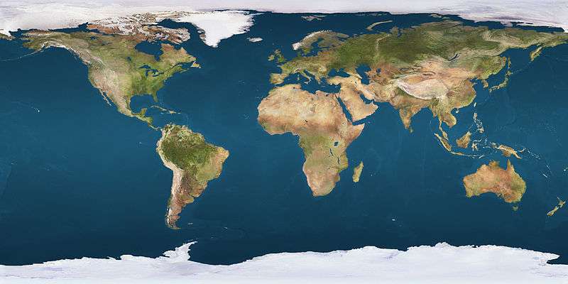
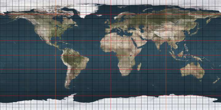
The 13th parallel south is a circle of latitude that is 13 degrees south of the Earth's equatorial plane. It crosses the Atlantic Ocean, Africa, the Indian Ocean, Australasia, the Pacific Ocean and South America.

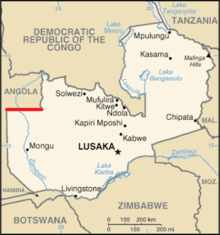
Part of the border between Angola and Zambia is defined by the parallel.

Around the world

Starting at the Prime Meridian and heading eastwards, the parallel 13° south passes through:

Co-ordinates Country, territory or sea Notes
13°0′S 0°0′E / 13.000°S 0.000°E / -13.000; 0.000 (Prime Meridian) Atlantic Ocean
13°0′S 12°57′E / 13.000°S 12.950°E / -13.000; 12.950 (Angola)  Angola
13°0′S 22°0′E / 13.000°S 22.000°E / -13.000; 22.000 (Angola / Zambia border)  Angola /  Zambia border
13°0′S 24°2′E / 13.000°S 24.033°E / -13.000; 24.033 (Zambia)  Zambia
13°0′S 28°49′E / 13.000°S 28.817°E / -13.000; 28.817 (Democratic Republic of the Congo)  Democratic Republic of the Congo
13°0′S 29°48′E / 13.000°S 29.800°E / -13.000; 29.800 (Zambia)  Zambia
13°0′S 33°0′E / 13.000°S 33.000°E / -13.000; 33.000 (Malawi)  Malawi
13°0′S 34°19′E / 13.000°S 34.317°E / -13.000; 34.317 (Lake Malawi) Lake Malawi
13°0′S 34°46′E / 13.000°S 34.767°E / -13.000; 34.767 (Mozambique)  Mozambique Passing through Pemba Bay
13°0′S 40°35′E / 13.000°S 40.583°E / -13.000; 40.583 (Indian Ocean) Indian Ocean Mozambique Channel
13°0′S 45°8′E / 13.000°S 45.133°E / -13.000; 45.133 (France)  France Overseas department of Mayotte
13°0′S 45°9′E / 13.000°S 45.150°E / -13.000; 45.150 (Indian Ocean) Indian Ocean Mozambique Channel
13°0′S 48°54′E / 13.000°S 48.900°E / -13.000; 48.900 (Madagascar)  Madagascar
13°0′S 49°53′E / 13.000°S 49.883°E / -13.000; 49.883 (Indian Ocean) Indian Ocean
13°0′S 125°49′E / 13.000°S 125.817°E / -13.000; 125.817 (Timor Sea) Timor Sea
13°0′S 130°8′E / 13.000°S 130.133°E / -13.000; 130.133 (Australia)  Australia Northern Territory
13°0′S 136°39′E / 13.000°S 136.650°E / -13.000; 136.650 (Gulf of Carpenteria) Gulf of Carpentaria
13°0′S 141°35′E / 13.000°S 141.583°E / -13.000; 141.583 (Australia)  Australia Cape York Peninsula, Queensland
13°0′S 143°31′E / 13.000°S 143.517°E / -13.000; 143.517 (Coral Sea) Coral Sea Passing just north of the Torres Islands,  Vanuatu
13°0′S 167°47′E / 13.000°S 167.783°E / -13.000; 167.783 (Pacific Ocean) Pacific Ocean Passing north of Wallis Island,  Wallis and Futuna
13°0′S 76°30′W / 13.000°S 76.500°W / -13.000; -76.500 (Peru)  Peru
13°0′S 68°58′W / 13.000°S 68.967°W / -13.000; -68.967 (Bolivia)  Bolivia
13°0′S 62°47′W / 13.000°S 62.783°W / -13.000; -62.783 (Brazil)  Brazil Rondônia - for about 3 km
13°0′S 62°46′W / 13.000°S 62.767°W / -13.000; -62.767 (Bolivia)  Bolivia For about 12 km
13°0′S 62°39′W / 13.000°S 62.650°W / -13.000; -62.650 (Brazil)  Brazil Rondônia
Mato Grosso
Goiás
Tocantins
Goiás
Tocantins
Goiás
Bahia - mainland, Itaparica Island and the mainland again (city of Salvador)
13°0′S 38°26′W / 13.000°S 38.433°W / -13.000; -38.433 (Atlantic Ocean) Atlantic Ocean

See also

This article is issued from Wikipedia - version of the 5/3/2016. The text is available under the Creative Commons Attribution/Share Alike but additional terms may apply for the media files.