Al-Bassa
| Al-Bassa | |
|---|---|
|
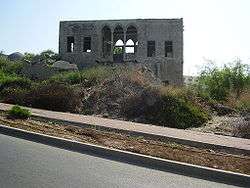
House of El Khouri Family (2008) | |
 Al-Bassa | |
| Arabic | البصة |
| Also spelled | Bezeth |
| Subdistrict | Acre |
| Coordinates | 33°04′34″N 35°08′27″E / 33.07611°N 35.14083°ECoordinates: 33°04′34″N 35°08′27″E / 33.07611°N 35.14083°E |
| Palestine grid | 164/276 |
| Population | 3,100 (1945) |
| Area |
25,258 dunams 25.2 km² |
| Date of depopulation | 14 May 1948[1] |
| Cause(s) of depopulation | Expulsion by Yishuv forces |
| Secondary cause | Military assault by Yishuv forces |
| Current localities | Betzet, Rosh HaNiqra, Shlomi,[2] Tzahal[3] |
al-Bassa' (Arabic: البصة), also known as Betzet in Hebrew: בצת, was a Palestinian Arab village in the Mandatory Palestine's Acre Subdistrict. It was situated close to the Lebanese border, 19 kilometers (12 mi) north of the district capital, Acre, and 65 meters (213 ft) above sea level.
The village was stormed by Haganah troops in May 1948 and almost completely razed. Its residents were either internally displaced or expelled to neighboring countries.[4]
Etymology
Bassa has been identified with the border town Betset (בצת) listed in the Tosefta and the Jerusalem Talmud as subject to the laws of Shmita.[5] It was called Bezeth during the Roman period, and its Arabic name is al-Basah.[6][7] In the period of Crusader rule in Palestine, it was known as Le Bace or LeBassa.[7] Imad ad-Din al-Isfahani (d. 1201), a chronicler and advisor to Saladin, referred to the village as Ayn al-Bassa.[8]
History
The site shows signs of habitation in prehistory and the Middle Bronze Age.[9] It was a Jewish settlement between 70 and 425 AD.[9] Blown glass pitchers uncovered in a tomb in al-Bassa were dated to circa 396 AD.[10] An ancient Christian burial place and 18 other archaeological sites were located in the village.
The Survey of Western Palestine, sponsored by the Palestine Exploration Fund, identified al-Bassa as, "probably a Crusading village"; however, archaeological excavations uncovered evidence of an ecclesiastical farm in operation there between the 5th to 8th centuries, and pottery sherds indicate continuous inhabitation throughout the Middle Ages.[7]
The site was used in 1189 C.E. as a Crusader encampment during a military campaign,[11] and a document dated October 1200 recorded the sale of the village by King Amalric II of Jerusalem to the Teutonic Order.[12] No Crusader era buildings have been found in al-Bassa, and a cross once dated to the Crusader period was later re-dated to the Byzantine era.[7] A-Bassa was the first village listed as part of the domain of the Crusaders during the hudna between the Crusaders based in Acre and the Mamluk sultan al-Mansur (Qalawun) in 1283.[13]
Ottoman era
In 1596, al-Bassa was part of the Ottoman Empire, a village in the nahiya (subdistrict) of Tibnin under the liwa' (district) of Safad, with a population of 76 Muslim families and 28 Muslim bachelors. It paid taxes on a number of crops, including wheat olives, barley, cotton and fruits, as well as on goats, beehives and pasture land.[14]
In the 18th century, al-Bassa became a zone of contention between Zahir al-Umar and the chiefs of Jabal Amil under Sheikh Nasif al-Nassar, while under his successor, Jezzar Pasha, al-Bassa was made the administrative center of the nahiya in around 1770.[15] In 1799, Napoleon Bonaparte described al-Bassa as a village of 600 Metawalis.[16] A map by Pierre Jacotin from Napoleon's invasion of that year showed the place, named as El Basa.[17]
The European explorer Van de Velde visited "el-Bussa" in 1851, and stayed with the sheikh, Aisel Yusuf, writing that "The clean house of Sheck Yusuf is a welcome sight, and the verdant meadows around the village are truly refreshing to the eye".[18] He further noted that "The inhabitants of Bussah are almost all members of the Greek Church. A few Musselmans live among them, and a few fellahs of a Bedouin tribe which wanders about in the neighborhood are frequently seen in the street."[19]
In 1863, the village was visited by Henry Baker Tristram who described it as a Christian village, where "olive oil, goats´hair, and tobacco, seemed to be principal produce of the district; the latter being exported in some quantities, by way of Acre, to Egypt. Bee-keeping, also, is not an unimportant item of industry, and every house possesses a pile of bee-hives in its yard."
| “ | The houses, excepting the very poorest, seem all alike. Each had a courtyard, with a high wall, for the goats, camels, firewood, and bees. At the end of the yard stands the mud-built house, with a single door opening into its one room. A pillar and two arches run across it, and support the flat roof. The door opens into the stable portion [] where horses and camels are standing before the manger of dried mud. Stepping up from this, the visitor finds himself at once in the simple dwelling-room of the family. A large matting of flattened rush generally covers one half, and a few cushions are spread in the corner, near the unglazed window. At the further end there are mud stairs leading up to the roof, the summer bedchamber of the family. Furniture there is none, except the few cooking utensils hanging on wooden pegs, a hole in the centre of the floor for holding the fire, with a few loose iron rods across the top, and the quaint wooden cradles of the babies, apparently hereditary heirlooms. In the better houses, there is a mat screen across the platform, behind which sleep the single women and girls. [] On the top of every house is a wattled booth of oleander boughs, sometimes of two stories, with a wicker-work floor, in which the inhabitants sleep during the hot weather [ ] The tough and tenacious leaves of the oleander never shrivel or fall off, and form an effectual shade for many weeks.[ ] | ” | |
| — Henry Baker Tristram[20] | |||
In the late 19th century, the village of Al-Bassa was described as being built of stone, situated on the edge of a plain, surrounded by large groves of olives and gardens of pomegranate, figs and apples. The village had about 1,050 residents.[21]
The village had a public elementary school for boys (built by the Ottomans in 1882), a private secondary school, and a public elementary school for girls.[22]
British Mandate era
The Franco-British boundary agreement of 1920 described an imprecisely defined boundary between Lebanon and Palestine. It appeared to pass close to the north of al-Bassa, leaving the village on the Palestinian side but cut off from much of its lands.[23] However the French government included al-Bassa in a Lebanese census of 1921 and granted citizenship to its residents.[24] Meanwhile, a joint British-French boundary commission was working to determine a precise border, making many adjustments in the process. By February 1922 it had determined a border that confirmed al-Bassa as being in Palestine. This became official in 1923.[23][24] The citizenship of the residents was changed to Palestinian in 1926.[24]
In 1922, the people of al-Bassa founded a local council which was responsible for managing its local affairs.[22] The British census of September 1922 listed a population of 867 Christians, 150 Metawalis and 1 Jew, though Kaufman reports that the Muslims were Sunni rather than Metawali.[24][25] The Christians were listed as Greek Catholic (Melchite) (721), Orthodox (120), Church of England (17), Armenian Catholic (8), and one Roman Catholic.[25] Its main economic activity was olive picking. At the 1931 census, which did not distinguish Metawalis from other Muslims, the village had 868 Muslims, 1076 Christians, and 4 Bahais.[26]
The 1938 camp of Jewish labourers and Notrim (police) for construction of Tegart's wall was located adjacent to the village, and it ultimately became the site of a Tegart fort. By 1945 the village was home to a regional college.
Important public structures at the time of its existence included two mosques, two churches, three schools and 18 other shrines both holy to Muslims and Christians. Al-Bassa was the only Palestinian village in the Galilee with a Christian high school.[27] Some of Bassa's former public structures have been preserved and are found today within the Israeli localities of Shlomi and Betzet.
The population had grown to 1360 Muslims and 1590 Christians by 1945,[28] in all, 2,950, all Arabs, with 25,258 dunums (6,241 acres) of land according to an official land and population survey.[29] Of this, Arabs used 614 dunams for citrus and bananas, 14,699 dunams were plantations and irrigable land; 10,437 were used for cereals,[30] while 132 dunams were built-up (urban) land.[31]
1938 massacre
In 1938, during the 1936–1939 Arab revolt in Palestine, the village was the scene of a massacre committed by British soldiers. On September 6, 1938, four soldiers of the Royal Ulster Rifles (RUR) were killed when their armoured car ran over a land mine near the village. In retaliation, British forces burnt the village down. After that, perhaps a few days later, about 50 Arabs from the village were collected by the RUR and some attached Royal Engineers. Some who tried to run away were shot. Then, according to British testimony, the remainder were put onto a bus which was forced to drive over a land mine laid by the soldiers, destroying the bus and killing many of the occupants. The village's inhabitants were then forced to dig a pit and throw all the bodies into it. Arab accounts added torture and other brutality. The total death toll was about 20.[32]
1940s
Al-Bassa was one of the largest, most developed villages in the north of the country, covering a land area of some 20,000 dunams of hills and plains, 2,000 of which were irrigated. A regional commercial center, it contained over sixty shops and eleven coffeehouses, a few of which sat along the Haifa-Beirut highway. The active village council had paved roads, installed a system of running water, and oversaw the convening of a wholesale produce market there every Sunday. An agricultural cooperative in the village counted over 150 members that promoted agricultural development, while also providing loans to local farmers. The population of about 4,000 was divided almost evenly between Muslims and Christians. Among the village institutions were a government run elementary school, a "National High School", a Greek Orthodox church, a Catholic church, and a mosque.[33] The village was situated in the territory allotted to the Arab state under the 1947 UN Partition Plan.
Israeli period
Al-Bassa was captured by Yishuv's Haganah forces during the 1948 Arab–Israeli War, in Operation Ben-Ami, on May 14, 1948. Al-Bassa's defenders were local militia men. Following its capture, the Haganah's Palmach forces concentrated the villagers in the local church where they shot and killed a number of youths before chasing the villagers out.[34] One witness to the expulsion said that it was preceded by soldiers shooting and killing five villagers inside the church, while another said seven villagers were shot and killed by soldiers outside the church.[33]
Al-Bassa was completely destroyed by the Israelis with the exception of a few houses, a church, and a Muslim shrine, still standing today. At least 60 of the Christian villagers of Al-Bassa were taken by the Haganah to Mazra'a, where they remained for more than a year.[35] Altogether 81 residents of al-Bassa became Israeli citizens as internally displaced Palestinians who lost their land rights and ended up in places like Nazareth.[22][36][37] The only day on which Palestinians did not require a permit to travel during that period was Israel's Independence Day.[37] On this day, which Palestinians call Nakba Day, internally displaced Palestinians would visit their former villages.[37] Wakim Wakim, an attorney from Al-Bassa and a leading member of the Association for the Defense of the Rights of the Internally Displaced explains: "The day when Israel celebrates is the day we mourn" (emphasis in original).[37]
Most of the former villagers of al-Bassa (circa 95%) were pushed north towards Lebanon, concentrating in the Dbayeh refugee camp near Jounieh east of Beirut.[22] Prior to and during the Lebanese Civil War, this camp suffered severe damage in the fighting and was largely destroyed, though it still has a population of some 4,233 people who are mostly Palestinian Christian refugees.[22] Other former residents of Al-Bassa and the refugee camp in Lebanon ended up in Lansing, Michigan where they established an international village club and hold annual gatherings attended by over 300 people.[22]
The village was inspected in 1992, when it was found that although most of the houses of Al-Bassa had been destroyed, a number of historic buildings survived, including two churches, a mosque, and a maqam.[38]
Architecture
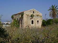
Mosque
According to Petersen, the mosque appears to be a relatively modern construct, probably built in the early 1900s. It consists of a tall square room with a flat roof supported by iron girders. There is a cylindrical minaret at the north-east corner. There are tall pointed windows on all four sides, and a mihrab in the middle of the south wall. At the time of the inspection, 1992, the building was used as a sheep pen.[38]
Maqam
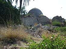
The maqam is located about 20 meters east of the mosque. It consists of two parts: a walled courtyard, and a domed prayer room. In the courtyard there is a mihrab in the south wall, and a doorway in the east wall leads into the main prayer room. Pendentives springing from four thick piers support wide arches and the dome. In the middle of the south wall there is a mihrab, next to a simple minbar, made of four stone steps.[38]
Culture
Henry Baker Tristram during his 1863 visit to the village made a detailed description of the women's Palestinian costumes.
| “ | [The women´s] dress was unlike any costume we had yet seen; consisting of rather tight blue cotton trousers tied at the ankle, slippers without stockings, a chemise of cotton, blue or white, rather open in front, and over this a long dress, like a cassock, open in front, with a girdle and short sleeves. This robe was plain, patched, or embroidered in the most fantastic and grotesque shapes, the triumph of El Bussah milliners being evidently to bring together in contrast as many colours as possible. The head-dress ...baffles my powers of description, but is very description, but is very interesting, as probably identical with that of the women of Galilee of old. [Such may Mary have worn, as she daily went to the well of Nazareth.] It is called the semadi, and consists of a cloth skull-cap, with a flap behind, all covered with coins -silver, but sometimes gold -and a fringe of coins suspended from it on the forehead. Round the face, from chin to crown, are two stout pads, by way of bonnet-cap, fastened at the top. But outside of these pads is attached a string of silver, not lengthwise, but solidly piled one on another, and hammered severally into a saucer-shape, with a hole drilled through the middle. They usually commence with some half-dozen Spanish dollars at the chin, gradually tapering up to small Turkish silver-pieces of the size of sixpences at the forehead. The weight is no trifle, and one little girl, whose head-gear was handed to me for examination in return for a present of needles, had £30 worth of silver round her cheeks. Many had frontlets of gold coins, and I saw one centre-piece on the fore-head of a sheikh's wife consisting of a Turkish £5 gold piece. All the young ladies thus carry their fortunes on their heads; and this jewelry is the peculium of the wife, and cannot be touched by her husband. An instance in which a Greek priest had insisted on the payment of his fees out of the head-dress of a widow has been recited to me as a case of grievous extortion. | ” | |
| — Henry Baker Tristram[39] | |||
Weir, after quoting what Tristram wrote about the head-dresses in Al-Bussah, notes that coin headdresses went out of use for daily wear in Galilee at the beginning of the 20th century, but continued to be worn by brides for their weddings.[40]
See also
References
- ↑ Morris, 2004, p. xvii, village #78. Also gives cause(s) of depopulation.
- ↑ Morris, 2004, p. xxii, settlement #153, in 1949-50.
- ↑ Morris, 2004, p. xxii, settlement #184, in 1949.
- ↑ Bardi, Ariel Sophia (March 2016). "The "Architectural Cleansing" of Palestine". American Anthropologist. 118 (1): 165–171. doi:10.1111/aman.12520.
- ↑ Neubauer, 1868, p 22. References: Tos. Shebiit 4:9, Yer. Demai 2:1 (Heb. 8b). For the identification with al-Bassa, also see Grootkerk, 2000, pp. 2–3 or Conder and Kitchener, 1881, SWP I, p. 167
- ↑ Avi Yonah, 1976, p. 42. Cited in Khalidi, 1992, p. 6.
- 1 2 3 4 Pringle, 1997, p. 116
- ↑ Khalidi, 1992, p. 6.
- 1 2 Grootkerk, 2000, p. 3
- ↑ Whitehouse and Corning Museum of Glass, 2002, p. 182
- ↑ Abu Shama, RHC Or, IV, p. 406. Cited in Petersen, 2001, p. 111
- ↑ Strehlke, 1869, pp. 30-31, No.38. Cited in Petersen, 2001, p. 111 and in Ellenblum, 2003, pp. 59, 146
- ↑ Dan Barag (1979). "A new source concerning the ultimate borders of the Latin Kingdom of Jerusalem". Israel Exploration Journal. 29: 197–217.
- ↑ Hütteroth and Abdulfattah, 1977, p. 181.
- ↑ Cohen, 1973, p 124. Cited in Khalidi, 1992, p.6
- ↑ Correspondance inédite officielle et confidentielle de Napoléon Bonaparte (Paris, 1819), vol. 4, p. 291
- ↑ Karmon, 1960, p. 160.
- ↑ Van de Velde, 1854, vol 1, p. 252
- ↑ Van de Velde, 1854, vol 1, p. 254
- ↑ Trisdam, 1865, pp.85- 86
- ↑ Conder and Kitchener, 1881, p. 145. Also quoted in Khalidi, 1992, p. 8
- 1 2 3 4 5 6 Hassoun, 2003, p. 26.
- 1 2 Gideon Biger (2004). The Boundaries of Modern Palestine, 1840-1947. London and New York: RoutledgeCurzon. p. 137. ISBN 0-7146-5654-2.
- 1 2 3 4 Asher Kaufman (2006). "Between Palestine and Lebanon: Seven Shi'i villages as a case study of boundaries, identities and conflict". The Middle East Journal. 60: 685–706.
- 1 2 Barron, 1923, Table XI, Sub-district of Acre, p. 36
- ↑ Mills, 1932, p. 99
- ↑ Mansour, 2004, p. 220.
- ↑ Government of Palestine, Village Statistics, 1945, p. 2
- ↑ Government of Palestine, Department of Statistics. Village Statistics, April, 1945. Quoted in Hadawi, 1970, p. 40
- ↑ Government of Palestine, Department of Statistics. Village Statistics, April, 1945. Quoted in Hadawi, 1970, p. 80
- ↑ Government of Palestine, Department of Statistics. Village Statistics, April, 1945. Quoted in Hadawi, 1970, p. 130
- ↑ Hughes, M. (2009) The Banality of Brutality: British Armed Forces and the Repression of the Arab Revolt in Palestine, 1936–39, English Historical Review Vol. CXXIV No. 507, 314–354.
- 1 2 Benvenisti, 2000, pp. 139 -140.
- ↑ Quigley, 2005, p. 62.
- ↑ Abassi, Mustafa; Henry Near (January 2007). "The General and the Village: The 1948 War and its Aftermath seen from the Sidelines". Israel Affairs. 13 (1): 24–54. doi:10.1080/13537120601063283.
- ↑ Areej Sabbagh-Khoury, The Internally displaced refugees.
- 1 2 3 4 Masalha and Said, 2005, p. 217
- 1 2 3 Petersen, 2001, p. 111
- ↑ Tristram, 1865, pp. 68-69
- ↑ Weir, 1989, pp.175-176
Bibliography
| Wikimedia Commons has media related to Al-Bassa. |
- Barron, J. B., ed. (1923). Palestine: Report and General Abstracts of the Census of 1922. Government of Palestine.
- Benveniśtî, Mêrôn (2000). Sacred landscape: the buried history of the Holy Land since 1948. University of California Press. ISBN 978-0-520-23422-2. (p. 333)
- Cohen, A. (1973), Palestine in the Eighteenth Century: Patters of Government and Administration. Hebrew University, Jerusalem. Cited in Khalidi, (1992)
- Conder, Claude Reignier; Kitchener, H. H. (1881). The Survey of Western Palestine: Memoirs of the Topography, Orography, Hydrography, and Archaeology. 1. London: Committee of the Palestine Exploration Fund. ( p.156 )
- Ellenblum, Ronnie (2003). Frankish Rural Settlement in the Latin Kingdom of Jerusalem. Cambridge University Press. ISBN 9780521521871.
- Grootkerk, Salomon E. (2000). Ancient sites in Galilee: a toponymic gazetteer (Illustrated ed.). BRILL. ISBN 978-90-04-11535-4.
- Hadawi, Sami (1970). Village Statistics of 1945: A Classification of Land and Area ownership in Palestine. Palestine Liberation Organization Research Center.
- Hassoun, Rosina J. (2003). Arab Americans in Michigan (Illustrated ed.). MSU Press. ISBN 978-0-87013-667-2.
- Hütteroth, Wolf-Dieter; Abdulfattah, Kamal (1977). Historical Geography of Palestine, Transjordan and Southern Syria in the Late 16th Century. Erlanger Geographische Arbeiten, Sonderband 5. Erlangen, Germany: Vorstand der Fränkischen Geographischen Gesellschaft. ISBN 3-920405-41-2.
- Karmon, Y. (1960). "An Analysis of Jacotin's Map of Palestine" (PDF). Israel Exploration Journal. 10 (3,4): 155–173; 244–253.
- Khalidi, Walid (1992). All That Remains: The Palestinian Villages Occupied and Depopulated by Israel in 1948. Washington D.C.: Institute for Palestine Studies. ISBN 0-88728-224-5.
- Mansour, Atallah (2004). Narrow Gate Churches: The Christian Presence in the Holy Land Under Muslim and Jewish Rule. Hope Publishing House. ISBN 978-1-932717-02-0.
- Masalha, Nur; Said, Edward W. (2005). Catastrophe remembered: Palestine, Israel and the internal refugees : essays in memory of Edward W. Said (1935-2003). Zed Books. ISBN 978-1-84277-623-0.
- Mills, E., ed. (1932). Census of Palestine 1931. Population of Villages, Towns and Administrative Areas. Jerusalem: Government of Palestine.
- Morris, Benny (2004). The Birth of the Palestinian Refugee Problem Revisited. Cambridge University Press. ISBN 978-0-521-00967-6.
- Neubauer, Adolf (1868). La géographie du Talmud : mémoire couronné par l'Académie des inscriptions et belles-lettres (in French). Paris: Lévy.
- Palmer, E. H. (1881). The Survey of Western Palestine: Arabic and English Name Lists Collected During the Survey by Lieutenants Conder and Kitchener, R. E. Transliterated and Explained by E.H. Palmer. Committee of the Palestine Exploration Fund.
- Petersen, Andrew (2001). A Gazetteer of Buildings in Muslim Palestine (British Academy Monographs in Archaeology). 1. Oxford University Press. ISBN 978-0-19-727011-0.
- Pringle, Denys (1997). Secular buildings in the Crusader Kingdom of Jerusalem: an archaeological gazetteer (Illustrated ed.). Cambridge University Press. ISBN 978-0-521-46010-1.
- Quigley, John B. (2005). The case for Palestine: an international law perspective (2nd, revised ed.). Duke University Press. ISBN 978-0-8223-3539-9.
- RHC Or: Recueil des historiens des croisades : Historiens orientaux (in French). 4. Paris: Imprimerie nationale. 1898.
- Rhode, Harold (1979). Administration and Population of the Sancak of Safed in the Sixteenth Century. Columbia University.
- Strehlke, Ernst, ed. (1869). Tabulae Ordinis Theutonici ex tabularii regii Berolinensis codice potissimum. Berlin: Weidmanns.
- Tristram, H.B. (1865). Land of Israel, A Journal of travel in Palestine, undertaken with special reference to its physical character. London: Society for Promoting Christian Knowledge.
- Velde, van de, Charles William Meredith (1854). Narrative of a journey through Syria and Palestine in 1851 and 1852. 1. William Blackwood and son.
- Weir, Shelagh (1989). Palestinian Costume. British Museum Publications Ltd. ISBN 0-7141-2517-2.
- Whitehouse, David; Corning Museum of Glass (2002). Roman glass in the Corning Museum of Glass, Volume 2 (Illustrated ed.). Hudson Hills. ISBN 978-0-87290-150-6.
External links and references
- Welcome to al-Bassa
- Survey of Western Palestine, Map 3: IAA, Wikimedia commons
- Al-Bassa at Khalil Sakakini Cultural Center
- Al-Bassah Dr. Moslih Kanaaneh
- Al-Bassa International Association - an "international forum" for former residents of al-Bassa.