Dayr al-Shaykh
| Dayr al-Shaykh | |
|---|---|
|
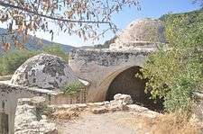
The zawiya at Dayr al-Shaykh, 2011. | |
 Dayr al-Shaykh | |
| Arabic | دير الشيخ |
| Name meaning | The monastery (sanctuary) of the Sheikh (elder, or chief)[1] |
| Also spelled | Dayr al-Sheikh, Deir el-Sheikh, Deir al Sheikh, Deir esh-Sheikh, Dar esh-Sheikh, Dar el-Sheikh, |
| Subdistrict | Jerusalem |
| Coordinates | 31°44′56″N 35°04′02″E / 31.74889°N 35.06722°ECoordinates: 31°44′56″N 35°04′02″E / 31.74889°N 35.06722°E |
| Palestine grid | 156/128 |
| Population | 220[2][3] (1945) |
| Area | 1,366[2][3] dunams |
| Date of depopulation | October 21, 1948[4] |
| Cause(s) of depopulation | Military assault by Yishuv forces |
Dayr al-Shaykh (Arabic: دير الشيخ) was a Palestinian Arab village in the Jerusalem Subdistrict, also known as the Jerusalem corridor. It was depopulated during the 1948 Arab-Israeli War. The village was located 16 kilometers (9.9 mi) west of Jerusalem, overlooking the Wadi al-Sarar stream to the northeast.
History
Mamluk period
During Mamluk times, Dayr al-Shaykh was home to one of the most famous local dynasties of local religious Shaykhs in the area. The founder was al-Sayyid Badr-al Din Muhammed who came to Palestine either from Iraq,[5] Khurasan,[6] or the Hijaz.[7] He first settled in Shuafat, but after the death of one of his daughters, whose tomb can still be seen in the village, he moved westwards.[8] According to the Mamluk-era historian Mujīr al-Dīn al-'Ulaymī, Badr-al Din probably arrived in Palestine around 1229-1244, and eventually he settled at Dayr al-Shaykh. According to the same source, Badr-al Din was a man of great virtue, with a reputation of being close to God. He died 1253 (650 AH), and was buried at his zawiya at Dayr al-Shaykh. Because of him, Dayr al-Shaykh attracted many disciples and other people who came for ziyara.[9]
Badr-al Din had eight sons; the oldest, al-Sayyid Muhammed (died 1264-65 (663 AH)), is also described as a guide and leader.[10] Abd al-Afiz (died 1296-97 (696 AH), another of his sons to attain leadership status, returned to Jerusalem to a village that was subsequently renamed Sharafat for this family of Ashraf ("nobles").[10]
Ottoman period
Dayr al-Shaykh, like the rest of Palestine, was incorporated into the Ottoman Empire in 1517, and according to an Ottoman census of 1596, the village had a population of 113. It was a part of the nahiya ("subdistrict") of Jerusalem which was under the administration of the liwa ("district") of Jerusalem. It paid taxes on wheat, barley, olives, fruits, beehives, goats, and vineyards.[11]
In 1834, when Ibrahim Pasha of Egypt led the Egyptian army into Palestine, he confiscated large areas of land once belonging to local leaders in the process. However, according to local tradition, when Ibrahim Pasha sent a regiment to confiscate the land of Dayr al-Shaykh, it was attacked by a swarm of bees. According to tradition, this was Shaykh Badr defending his abode.[12][13]
An Ottoman village list of about 1870 found 28 houses and a population of 101, though the population count included only men,[14] while the population grew to about 400 by the early 1870s.[2] However, the village was described as deserted by 1883.[15] Palestinian historian Walid Khalidi writes that the inhabitants might either have migrated elsewhere for a temporary period or died during the typhus epidemic that swept the area in 1874.[2] However, according to P.J. Baldensperger, writing in 1894, Sheikh Ethman, a direct descendant of Shaykh Badr, was partly a resident of Artas, partly of Dayr al-Shaykh, from 1874-1882. Sheikh Ethman, described in 1894 as a man about 50, with "fine features, tall, and very sober in speech", wore a green turban as a symbol of his descent from Husayn. He had been greatly revered by everybody until an incident in 1881, involving the escape of a criminal, had left his reputation diminished.[16]
British Mandate in Palestine
Along with all of Palestine, Dayr al-Shaykh became part of the British Mandate in 1920 following the region's capture from the Ottoman Turks by Great Britain. By this time, the village was repopulated;[2] in the 1922 census of Palestine Dayr al-Shaykh had a population 99, all Muslims,[17] increasing in the 1931 census to 156 inhabitants, in 26 houses; 148 Muslims, seven Christians, and one Jew were counted.[18] In 1945 the population reached 220.[3] Most of the residents' houses were built from stone. There were a few shops in the village and a well to the west provided drinking water. Most of its cultivable land was used for grain, vegetables and fruit trees. Large swathes of land to the east, west and north of Dayr al-Shaykh were covered by olive groves. The village had two mosques, one with a notable large dome to the east, and a rock-cut tomb to the southwest. Within the village lay the tomb and mosque of Shaykh Sultan Badr.[2] In 1944-45, the village had 1,025 dunums of land used for cereals, while 291 dunums were irrigated or used for orchards.[2][19]
1948, and afterwards
Dayr al-Shaykh was depopulated during the 1948 Arab-Israeli War. The village was occupied by Israel's Har'el Brigade, probably on October 21, 1948 during Operation ha-Har.[2] No Jewish locality was built on village lands which amounted to 6,781 dunams in 1945. The mosque of Shaykh Sultan Badr remains and is currently a tourist attraction.[2]
The Israeli town of Nes Harim is located 1 kilometer (0.62 mi) southwest of the village site, on land formerly belonging to Bayt 'Itab.[2]
Andrew Petersen, an archaeologist specializing in Islamic architecture, surveyed the shrine in 1994. The shrine consists of four main structures: a courtyard, a prayer hall, a maqam and a crypt. His conclusion was that the complex evolved over several hundred years, but that the oldest part is the vaulted crypt. This crypt, with the entrance in the south-east corner of the courtyard, has pointed arches which indicate a medieval, possibly Crusader date. The maquam belongs to a second phase of constructions, probably built shortly after the death of Sheik Badr in the 13th century. The prayer hall, which is located in the south-west corner of the complex, is the largest building and was probably constructed during late Mamluk, possibly early Ottoman times.[20]
Notes
- ↑ Palmer, 1881, p.293
- 1 2 3 4 5 6 7 8 9 10 11 Khalidi, 1992, p. 288
- 1 2 3 Government of Palestine, Department of Statistics. Village Statistics, April, 1945. Quoted in Hadawi, 1970, p. 57
- ↑ Morris, 2004, p. xx, village #351. Also gives cause of depopulation, with a "(?)"
- ↑ Ephrat, 2008, p. 158, based on Mujīr al-Dīn al-'Ulaymī's (c. 1495): al-Uns al-Jalīl ("The glorious history of Jerusalem and Hebron")
- ↑ Petersen, 2001, p. 136, based on Canaan, 1927, p. 307
- ↑ Petersen, 2001, p. 136, based on Masterman and Macalister, 1916, p. 12
- ↑ Petersen, 2001, p. 136
- ↑ Ephrat, 2008, pp. 158 -159, based on Mujīr al-Dīn
- 1 2 Ephrat, 2008, p. 159
- ↑ Hütteroth and Abdulfattah, 1977, p. 113. Quoted in Khalidi, 1992, p. 288
- ↑ Baldensperger, 1894, p. 35
- ↑ Baldensperger, 1913, p. 90
- ↑ Socin, 1879, p. 152
- ↑ Conder and Kitchener, 1883, SWP, Vol. 3, p.24 -p.25. Quoted in Khalidi, 1992, p. 288
- ↑ Baldensperger, 1894, pp. 35 -36
- ↑ Barron, 1923, Table VII, Sub-district of Jerusalem, p. 15
- ↑ Mills, 1932, p. 39
- ↑ Government of Palestine, Department of Statistics. Village Statistics, April, 1945. Quoted in Hadawi, 1970, p. 102
- ↑ Petersen, 2001, pp. 136-138
References
| Wikimedia Commons has media related to Dayr al-Shaykh. |
- Baldensperger, P. J. (1894). "Orders of Holy Men in Palestine". Quarterly statement - Palestine Exploration Fund. 26: 22–37.
- Baldensperger, P. J. (1913). The Immovable East: Studies of the People and Customs of Palestine. Boston: Pitman.
- Barron, J.B., ed. (1923). Palestine: Report and General Abstracts of the Census of 1922. Government of Palestine.
- Benvenisti, Meron (2002). Sacred Landscape: The Buried History of the Holy Land Since 1948. University of California Press. ISBN 978-0-520-23422-2.
- Canaan, Tawfiq (1927). Mohammedan Saints and Sanctuaries in Palestine. London: Luzac & Co.
- Conder, C. R. (1881). "Lieutenants Conder´s report". Quarterly statement - Palestine Exploration Fund. 13: 247–281. (p. 264)
- Conder, Claude Reignier; Kitchener, H. H. (1883). The Survey of Western Palestine: Memoirs of the Topography, Orography, Hydrography, and Archaeology. 3. London: Committee of the Palestine Exploration Fund.
- Ephrat, Daphna (2008). Spiritual wayfarers, leaders in piety: Sufis and the dissemination of Islam. Harvard CMES. ISBN 0-67403-201-2.
- Hadawi, Sami (1970). Village Statistics of 1945: A Classification of Land and Area ownership in Palestine. Palestine Liberation Organization Research Center.
- Hütteroth, Wolf-Dieter; Abdulfattah, Kamal (1977). Historical Geography of Palestine, Transjordan and Southern Syria in the Late 16th Century. Erlanger Geographische Arbeiten, Sonderband 5. Erlangen, Germany: Vorstand der Fränkischen Geographischen Gesellschaft. ISBN 3-920405-41-2.
- Khalidi, Walid (1992). All That Remains: The Palestinian Villages Occupied and Depopulated by Israel in 1948. Washington D.C.: Institute for Palestine Studies. ISBN 0-88728-224-5.
- Macalister, R. A. Stewart; Masterman, E. W. G. (1916). "Occasional Papers on the Modern inhabitants of Palestine". Quarterly statement - Palestine Exploration Fund: January. pp. 11–16, April, pp 64–71, July, pp. 126–137.
- Mills, E, ed. (1932). Census of Palestine 1931. Population of Villages, Towns and Administrative Areas. Jerusalem: Government of Palestine.
- Morris, Benny (2004). The Birth of the Palestinian Refugee Problem Revisited. Cambridge University Press. ISBN 978-0-521-00967-6.
- Palmer, E. H. (1881). The Survey of Western Palestine: Arabic and English Name Lists Collected During the Survey by Lieutenants Conder and Kitchener, R. E. Transliterated and Explained by E.H. Palmer. Committee of the Palestine Exploration Fund.
- Petersen, Andrew (2001). A Gazetteer of Buildings in Muslim Palestine (British Academy Monographs in Archaeology). 1. Oxford University Press. ISBN 978-0-19-727011-0.
- Socin, A. (1879). "Alphabetisches Verzeichniss von Ortschaften des Paschalik Jerusalem". Zeitschrift des Deutschen Palästina-Vereins. 2: 135–163.
External links
- Welcome To Dayr al-Shaykh
- Survey of Western Palestine, Map 17: IAA, Wikimedia commons
- Dayr Al-Shaykh from the Khalil Sakakini Cultural Center
- Dary al- Shaykh, Palestine Family.net
- Maqam Sheikh Badr el-Din el-Jimali