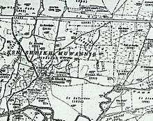
Al-Shaykh Muwannis
| Al-Shaykh Muwannis | |
|---|---|
 | |
 Al-Shaykh Muwannis | |
| Arabic | الشيخ مونّس |
| Name meaning | "The Sheikh Muwannis"[1] |
| Also spelled | Sheikh Muwannis |
| Subdistrict | Jaffa |
| Coordinates | 32°06′50″N 34°48′15″E / 32.11389°N 34.80417°ECoordinates: 32°06′50″N 34°48′15″E / 32.11389°N 34.80417°E |
| Palestine grid | 131/168 |
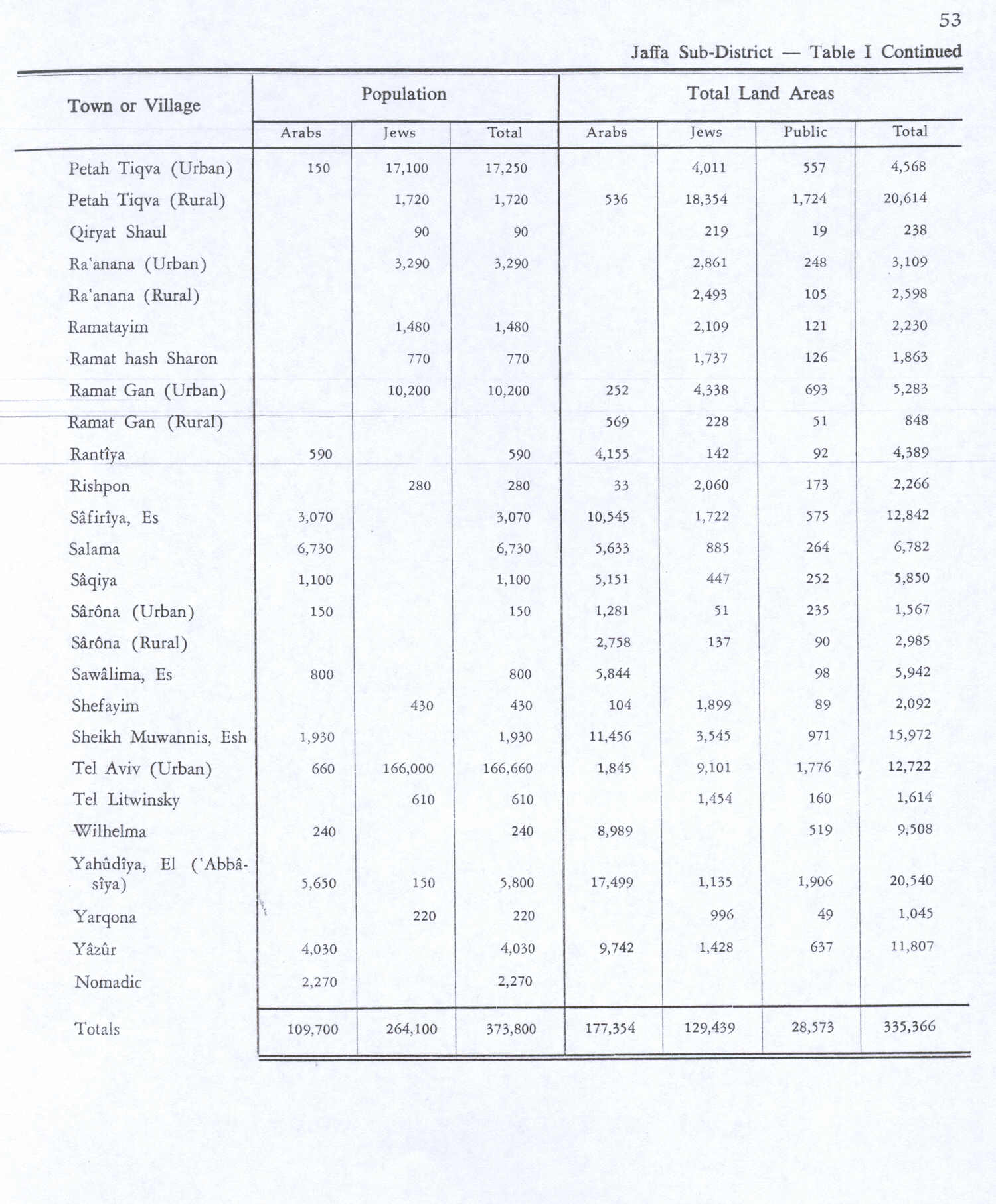
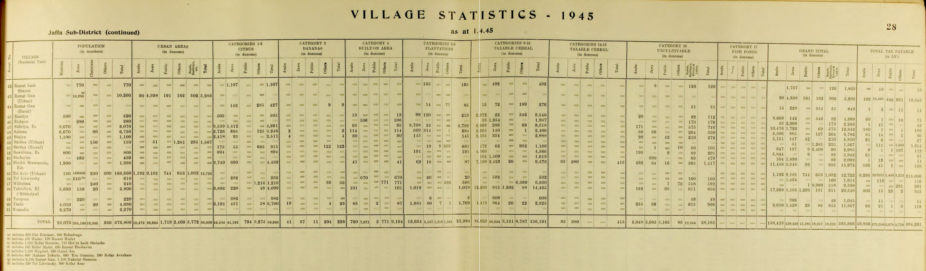
| Population | 1,930[2][3] (1945) |
| Area | 15,972 dunams |
| Date of depopulation | March 30, 1948[4] |
| Cause(s) of depopulation | Military assault by Yishuv forces |
| Secondary cause | Fear of being caught up in the fighting |
| Current localities | Tel Aviv |
Al-Shaykh Muwannis (Arabic: الشيخ مونّس), also Sheikh Munis, was a small Palestinian Arab village in the Jaffa Subdistrict of Mandatory Palestine,[5] located approximately 8.5 kilometers from the center of Jaffa city in territory earmarked for Jewish statehood under the UN Partition Plan.[6] The village was abandoned in March 1948 under pressure from Jewish militia, two months before the 1948 Arab–Israeli war. Today, Tel Aviv University lies on part of the village land.[5]
History
According to local legend, the village was named for a local religious figure, al-Shaykh Muwannis, whose tomb/shrine (maqam) was in the village.[7]
Ottoman era
During the Ottoman era, Pierre Jacotin named the village Dahr on his map from 1799.[8]
Al-Shaykh Muwannis was noted in December 1821, as being "located on a hill surrounded by muddy land that was flooded with water despite the moderate winter"[9]
In 1870, Victor Guérin found that al-Shaykh Muwannis contained four hundred inhabitants and was divided into several districts, each under the jurisdiction of a distinct Sheikh. Around the village there were some gardens which "delicious watermelons."[10] In 1882, the Palestine Exploration Fund's Survey of Western Palestine (SWP) noted "ruins of a house near the kubbeh",[11] while Al-Shaykh Muwannis was described as an ordinary adobe village.[12] Most of the villagers were members of the Abu Kishk tribe.[13]
The village population was 315 in 1879.[14]
British Mandate era
In the 1922 census of Palestine conducted by the British Mandate authorities, Shaik Muannes had a population of 664 residents, all Muslims.[15] This had increased in the 1931 census when Esh Sheikh Muwannis had 1154 inhabitants, still all Muslims, in 273 houses.[16]
In the 1920s, the government of the British mandate attempted to gain title to lands lying to the west of Al-Shaykh Muwannis and extending to the coast of the Mediterranean sea on the grounds that it was "waste and uncultivated."[17] According to the authors of a book on the Israeli-Arab conflict, the Arabs of the Jaffa-Tel Aviv region "understood the implications of the Zionist-cum-British discourses of development generally and their implementation through town planning schemes."[18]In 1937, the Arabic daily al Ja'miah al-Islamiyya commented on British plans to build a bypass road for Tel Aviv residents on what they claimed were village lands:[19] "[I]n reality the plan in the Town Planning Commission now including Sheikh Muwannis is not really a 'plan', but rather a plan to take the land out of the hands of its owners."[18]
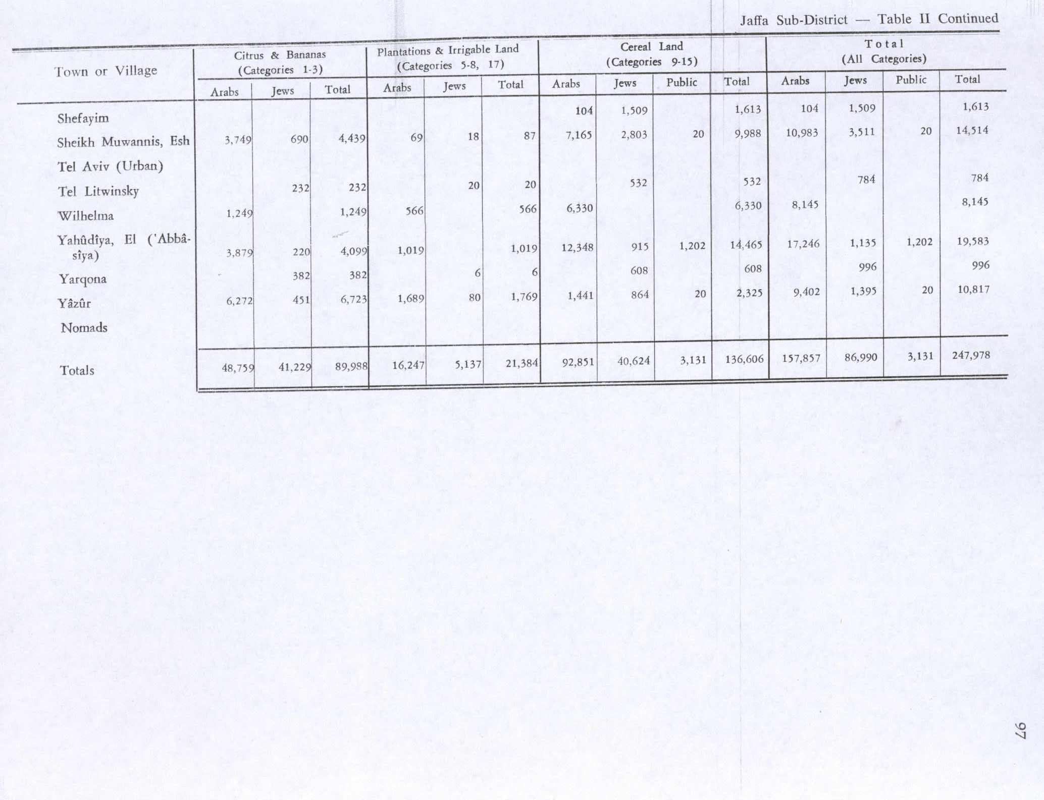
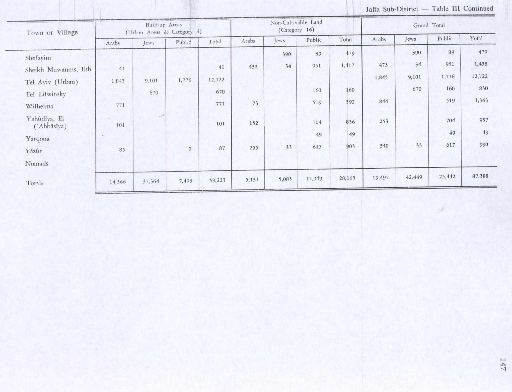
There were two schools in the village, a boys' school built in 1932 and a girls' school built in 1943. 266 students were registered in these schools in 1945.[7] The villagers worked in agriculture, particularly citrus cultivation. In 1944/45 3,749 dunums were used for growing citrus and bananas, and 7,165 dunums of village land was used for cereals. 66 dunums were irrigated or used for orchards, irrigation water was drawn from al-Awja river and a large number of artesian wells.[7][20] 41 dunams of village lands were classified as built-up areas.[21]
In 1946, three Arab villagers raped a Jewish girl. In the midst of the court proceedings, members of the Haganah shot and wounded one of the attackers, and kidnapped and castrated another.[13] In 1947, in the wake of growing hostility in the days leading up to the war, some of the villagers began to leave. Most stayed, as village notables had secured Haganah protection in exchange for keeping the peace and preventing Arab Liberation Army (ALA) irregulars from the using the village to attack Yishuv forces.[13]
Before the 1948 war, the population of al-Shaykh Muwannis was 2,000.[7]
1948 war and aftermath
The village was abandoned in March 1948 under pressure from Jewish militia, two months before the 1948 Arab–Israeli war. In 1948, the population was largely made up of fellaheen who enjoyed friendly relations with Jews, despite occasional tension.[13] While occasional shots were fired from the village toward Jewish residential areas in January and February 1948, there were no casualties, and the Abu Kishk abided by their promise to keep out ALA irregulars. The emissary of the ALA was informed by the Abu Kishk that "the Arabs of the area will cooperate with the Jews against any outside force that tries to enter."[13]
In mid-March, the Alexandroni Brigade of the IDF imposed a 'quarantine' on the village, Abu Kishk and two smaller satellite villages of Jalil al Shamaliyya and Jalil al Qibliya and may even have occupied houses on the edge of village.[13]
On March 12, 1948, the Irgun and Lehi (LHI) groups kidnapped five village notables.[22] The Intelligence Services of the IDF noted that
"many of the villagers ... began fleeing following the abduction of the notables of Sheikh Muwannis. The Arab learned that it was not enough to reach an agreement with the Haganah and that there were 'other Jews' of whom to beware, and possibly to be aware of more than the Haganah, which had not control over them."[22]
Though the notables were turned over to the Haganah on the 23 March and returned to Shaykh Muwannis, most of the villagers there and in other villages north of the Yarkon River continued to leave, as their confidence had been "mortally undermined".[13] Tawfiq Abu Kishk threw a large parting 'banquet' for the remaining villagers and their Jewish friends on the 28 March 1948.[13] After their departure, the village lands were promptly allocated for Jewish use by the Yishuv leaders,[13] and were ultimately incorporated into the municipality of Tel Aviv.[17]
In the days following, the Abu Kishk leaders attributed their abandonment of the village to: "a) the [Haganah] roadblocks ... b) the [Haganah] limitations on movement by foot, c) the theft [by Jews?] of vehicles, and d) the last kidnapping of Sheikh Muwannis men by the LHI." The villagers of Shaykh Muwannis became refugees, with the majority taking up residence in Qalqilya and Tulkarem.[13]
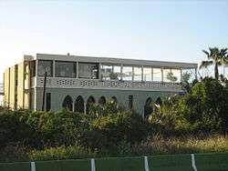
According to the Palestinian historian Walid Khalidi, the village's remaining structures in 1992 consisted of several houses occupied by Jewish families and the wall of a house.[7]Tel Aviv University lies on the land of Al-Shaykh Muwannis and the former home of the village sheikh serves as the University's faculty club.[5]
In a right of return march organized by the Israeli group Zochrot on Nakba Day in 2004, participants called upon the Tel Aviv municipality to name six streets in the city after Palestinian villages that had existed there until 1948, among them, Al-Shaykh Muwannis.[23]
See also
References
- ↑ Palmer, 1881, p. 218
- ↑ Government of Palestine, Department of Statistics. Village Statistics, April, 1945. Quoted in Hadawi, 1970, p. 53
- ↑ Department of Statistics, 1945, p. 28
- ↑ Morris, 2004, p. xviii, village #200. Also gives causes of depopulation.
- 1 2 3 Daniel Monterescu and Dan Rabinowitz (2007). Mixed Towns, Trapped Communities: Historical Narratives, Spatial Dynamics, Gender Relations and Cultural Encounters in Palestinian-Israeli Towns. Ashgate Publishing, Ltd. p. 298. ISBN 0-7546-4732-3.
- ↑ Benny Morris (Autumn 1991). "Response to Finkelstein and Masalha". Journal of Palestine Studies. 21 (1): 98–114. doi:10.1525/jps.1991.21.1.00p00682.
- 1 2 3 4 5 Khalidi, 1992, p. 260
- ↑ Karmon, 1960, p. 170
- ↑ Berggren, "Resor i Europa och österlanderna", Stockholm, 1828, p.61; cited in Sand, 2012, p. 262
- ↑ Guérin, 1870, p. 274
- ↑ Conder and Kitchener, 1882, SWP II, p. 275
- ↑ Conder and Kitchener, 1882, SWP II, p. 254
- 1 2 3 4 5 6 7 8 9 10 Morris, 2004, pp. 127–128
- ↑ PEF; cited in Sand, 2012, p. 262
- ↑ Barron, 1923, Table VII, Sub-district of Jaffa, p. 20
- ↑ Mills, 1932, p. 14
- 1 2 Haim Yacobi (2004). Constructing a Sense of Place: Architecture and the Zionist Discourse. Ashgate Publishing, Ltd. p. 199. ISBN 0-7546-3427-2.
- 1 2 Sandra M. Sufian and Mark LeVine (2007). Reapproaching Borders: New Perspectives on the Study of Israel-Palestine. Rowman & Littlefield. p. 298. ISBN 0-7425-4639-X.
- ↑ Huri İslamoğlu-İnan (2004). Constituting Modernity: Private Property in the East and West By Huri İslamoğlu-İnan. I.B.Tauris. p. 141. ISBN 1-86064-996-3.
- ↑ Government of Palestine, Department of Statistics. Village Statistics, April, 1945. Quoted in Hadawi, 1970, p. 97
- ↑ Government of Palestine, Department of Statistics. Village Statistics, April, 1945. Quoted in Hadawi, 1970, p. 147
- 1 2 Ilan Pappe (1999). The Israel/Palestine Question. Routledge. p. 199. ISBN 0-415-16947-X.
- ↑ "The Threat of Disengagement: Can Israel Separate from the Palestinians?" (PDF). Al-Majdal. Issue. Badil. 22. June 2004.
Bibliography
| Wikimedia Commons has media related to Al-Shaykh Muwannis. |
- Barron, J. B., ed. (1923). Palestine: Report and General Abstracts of the Census of 1922. Government of Palestine.
- Conder, Claude Reignier; Kitchener, H. H. (1882). The Survey of Western Palestine: Memoirs of the Topography, Orography, Hydrography, and Archaeology. 2. London: Committee of the Palestine Exploration Fund.
- Department of Statistics (1945). Village Statistics, April, 1945. Government of Palestine.
- Guérin, Victor (1875). Description Géographique Historique et Archéologique de la Palestine (in French). 2: Samarie, pt. 2. Paris: L'Imprimerie Nationale.
- Hadawi, Sami (1970). Village Statistics of 1945: A Classification of Land and Area ownership in Palestine. Palestine Liberation Organization Research Center.
- Karmon, Y. (1960). "An Analysis of Jacotin's Map of Palestine" (PDF). Israel Exploration Journal. 10 (3,4): 155–173; 244–253.
- Khalidi, Walid (1992). All That Remains: The Palestinian Villages Occupied and Depopulated by Israel in 1948. Washington D.C.: Institute for Palestine Studies. ISBN 0-88728-224-5. ISBN 0-88728-224-5.
- Mills, E., ed. (1932). Census of Palestine 1931. Population of Villages, Towns and Administrative Areas (PDF). Jerusalem: Government of Palestine.
- Morris, Benny (2004). The Birth of the Palestinian Refugee Problem Revisited. Cambridge University Press. ISBN 0-521-00967-7.
- Palmer, E. H. (1881). The Survey of Western Palestine: Arabic and English Name Lists Collected During the Survey by Lieutenants Conder and Kitchener, R. E. Transliterated and Explained by E.H. Palmer. Committee of the Palestine Exploration Fund.
- Sand, Shlomo (2012). The Invention of the Land of Israel: From Holy Land to Homeland. Verso Books. ISBN 978-1-84467-946-1.
External links
- Welcome to al-Shaykh-Muwannis,
- Survey of Western Palestine, Map 13: IAA, Wikimedia commons
- All About... Shaykh Muwannis, from Zochrot
- Meeting the bulldozers at the Baydas House, Shaykh Muwannis (Ramat Aviv), Zoroch
- Tel Aviv University is asked to acknowledge its past and to commemorate the Palestinian village on which grounds the university was built, 2003, Zochrot
- al-Shaykh Muwannis tour - report 2003.
- Map, 1946