Zikrin
| Zikrin | |
|---|---|
 Zikrin | |
| Arabic | ذكرين |
| Name meaning | Dhikerin the cool[1] |
| Also spelled | Dhikerin[2] |
| Subdistrict | Hebron |
| Coordinates | 31°39′48.30″N 34°51′38.25″E / 31.6634167°N 34.8606250°ECoordinates: 31°39′48.30″N 34°51′38.25″E / 31.6634167°N 34.8606250°E |
| Palestine grid | 136/119 |
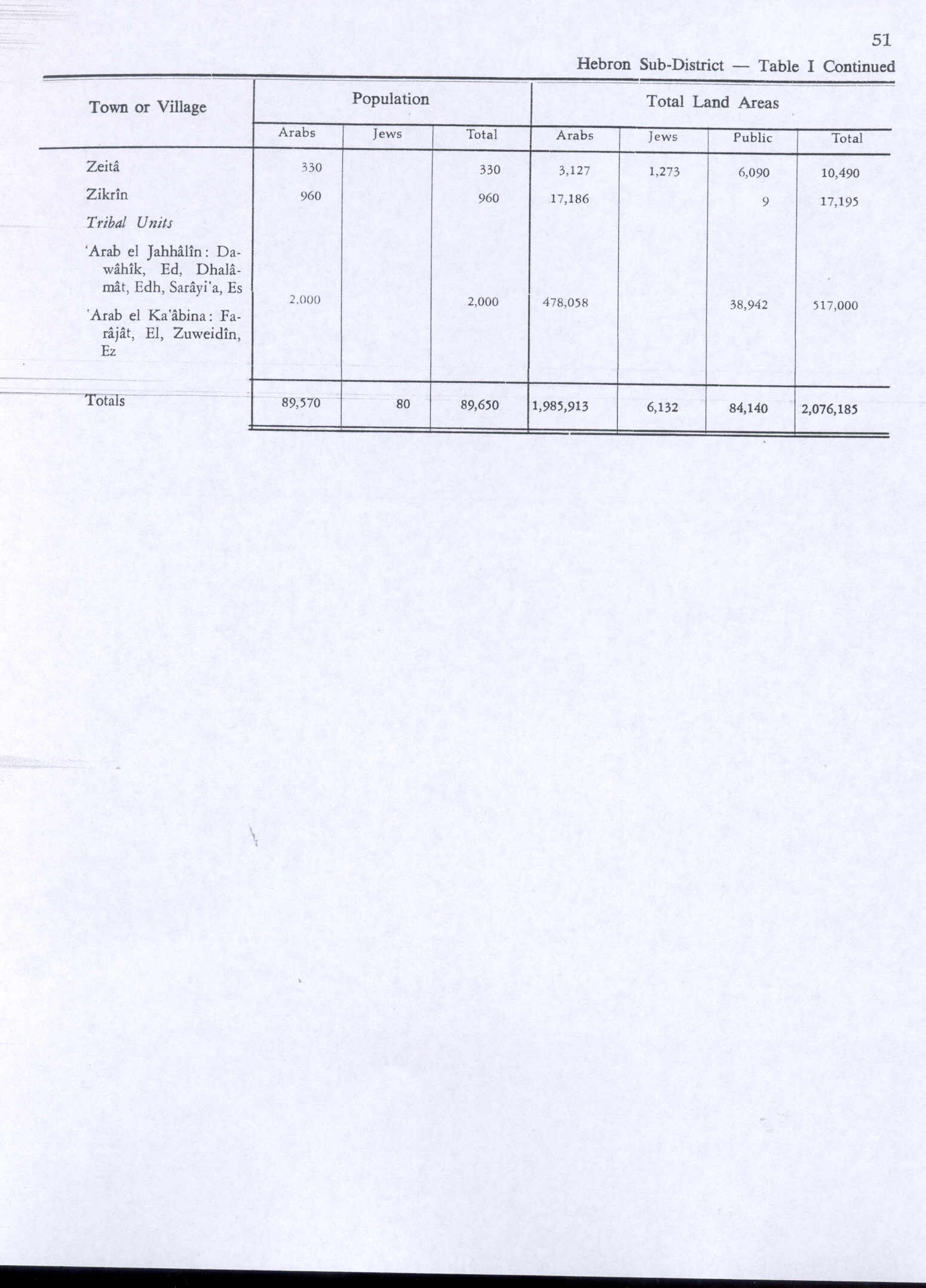
| Population | 960[3][4] (1945) |
| Area | 17,195[3] dunams |
| Date of depopulation | 22–23 October 1948[5] |
| Cause(s) of depopulation | Military assault by Yishuv forces |
Zikrin (Arabic: ذكرين) was a Palestinian Arab village in the Hebron Subdistrict, depopulated in the 1948 Palestine War.
History
The village was called Kefar Dikrina in Roman times.[6]
In 1479, it was mentioned by Tucher of Nurnberg, who travelled from Bethlehem to Gaza and lodged at Zikrin. He noted cisterns here.[7]
Ottoman era
In 1596, Zikrin was part of the Ottoman Empire, nahiya (subdistrict) of Gaza under the liwa' (district) of Gaza with a population of 220. It paid taxes on a number of products, including wheat, barley, sesame and fruits, and on vineyards.[8]
In 1838, Edward Robinson described it as a "large" village.[7]
In 1863 Victor Guérin visited, and found here a village with about 600 inhabitants. On the west side of the village there were as many as 40 cisterns. Guérin toured the village with the village Sheikh, who he described as a "tall, young and intelligent" man, whose father was Sheikh in Bayt Jibrin, and whose uncles were the same in Tell es-Safi and 'Ajjur.[9] An Ottoman village list of about 1870 showed that Zikrin had 38 houses and a population of 101, though the population count included men only.[10]
In 1883, the Palestine Exploration Fund's Survey of Western Palestine described Zikrin as being built of stone, and surrounded by gardens. It had "numerous" water wells below it.[2][6]
British Mandate era
In the 1922 census of Palestine conducted by the British Mandate authorities, Zekrin had a population of 693, all Muslims,[11] increasing in the 1931 census to 726, still all Muslim, in a total of 181 houses.[12]
The modern village had an elementary school, and a number of small shops. The villagers, who were Muslim, worked in agriculture and animal husbandry.[6]
In 1945, it had a population of 960, all Muslims,[4] and a total land area of 17,195 dunams.[3] In 1944/45 15,058 dunams (15.058 km2; 5.814 sq mi) of village land was planted with cereals,[6][13] while 63 dunams were built-up (urban) areas.[14]
Trees, shrubs, and wild grass grew on the south and southeast sides and serves as pastures.[6]
1948, and aftermath
On 6 August 1948, in the middle of an official truce, two squads from the 53rd Battalion of the Givati Brigade raided Zikrin, lobbing grenades and torching three or four houses. About 10 adult males, two children and one woman were killed in the village, according to IDF sources. The last three were killed accidentally, according to the report, while IDF suffered one soldier "slightly injured."[15]
Zikrin was finally depopulated on 22–23 October 1948 during the third stage of Operation Yoav under the command of Yigal Allon.[6] According to Morris, most of the villagers fled before the troops arrived, those who remained were expelled eastwards.[16] According to Morris, Yigal Allon was so successful in completely driving out the local population during Operation Yo'av, that the villagers found it almost impossible to "reinfiltrate" to their old villages, as there was no longer any local Arab population to help them resettle. During a military "sweep" of the villages in early 1949, they found most villages empty. In Zikrin it is reported that the troops found "two Arabs" who "managed to escape."[17]
Presently, there are no settlements on village land. The kibbutz, Beit Nir, is about 3 km south of the village site.[6]
The Palestinian historian Walid Khalidi described the village site in 1992 as being overgrown with tall weeds, scrub, and other wild vegetation, containing a number of olive and carob trees. Truncated stone terraces, partially overgrown with cactuses, further marked the site. Some of the surrounding lands was cultivated by Israeli farmers for wheat, and the rest used as rangeland.[6]
References
- ↑ Palmer, 1881, p. 367
- 1 2 Conder and Kitchener, 1883, p. 258.
- 1 2 3 Government of Palestine, Department of Statistics. Village Statistics, April, 1945. Quoted in Hadawi, 1970, p. 51
- 1 2 Department of Statistics, 1945, p. 23
- ↑ Morris, 2004, p. xix, village #297. Also gives cause of depopulation
- 1 2 3 4 5 6 7 8 Khalidi, 1992, p. 228
- 1 2 Robinson and Smith, 1841, vol 2, pp. 362-363
- ↑ Hütteroth and Abdulfattah, 1977, p. 147. Quoted in Khalidi, 1992, p. 228
- ↑ Guérin, 1869, pp. 107 -108
- ↑ Socin, 1879, p. 163
- ↑ Barron, 1923, Table V, Sub-district of Hebron, p. 10
- ↑ Mills, 1932, p. 34
- ↑ Government of Palestine, Department of Statistics. Village Statistics, April, 1945. Quoted in Hadawi, 1970, p. 94
- ↑ Government of Palestine, Department of Statistics. Village Statistics, April, 1945. Quoted in Hadawi, 1970, p. 144
- ↑ Morris, 2004, p. 447, note 213
- ↑ Morris, 2004, p. 466
- ↑ Morris, 2004, pp. 518-9
Bibliography
- Barron, J. B., ed. (1923). Palestine: Report and General Abstracts of the Census of 1922. Government of Palestine.
- Conder, Claude Reignier; Kitchener, H. H. (1883). The Survey of Western Palestine: Memoirs of the Topography, Orography, Hydrography, and Archaeology. 3. London: Committee of the Palestine Exploration Fund.
- Department of Statistics (1945). Village Statistics, April, 1945. Government of Palestine.
- Guérin, Victor (1869). Description Géographique Historique et Archéologique de la Palestine (in French). 1: Judee, pt. 2. Paris: L'Imprimerie Nationale.
- Hadawi, Sami (1970). Village Statistics of 1945: A Classification of Land and Area ownership in Palestine. Palestine Liberation Organization Research Centre.
- Hütteroth, Wolf-Dieter; Abdulfattah, Kamal (1977). Historical Geography of Palestine, Transjordan and Southern Syria in the Late 16th Century. Erlanger Geographische Arbeiten, Sonderband 5. Erlangen, Germany: Vorstand der Fränkischen Geographischen Gesellschaft. ISBN 3-920405-41-2.
- Khalidi, Walid (1992). All That Remains: The Palestinian Villages Occupied and Depopulated by Israel in 1948. Washington D.C.: Institute for Palestine Studies. ISBN 0-88728-224-5. ISBN 0-88728-224-5.
- Mills, E., ed. (1932). Census of Palestine 1931. Population of Villages, Towns and Administrative Areas (PDF). Jerusalem: Government of Palestine.
- Morris, Benny (2004). The Birth of the Palestinian Refugee Problem Revisited. Cambridge University Press. ISBN 978-0-521-00967-6.
- Palmer, E. H. (1881). The Survey of Western Palestine: Arabic and English Name Lists Collected During the Survey by Lieutenants Conder and Kitchener, R. E. Transliterated and Explained by E.H. Palmer. Committee of the Palestine Exploration Fund.
- Robinson, Edward; Smith, Eli (1841). Biblical Researches in Palestine, Mount Sinai and Arabia Petraea: A Journal of Travels in the year 1838. 2. Boston: Crocker & Brewster.
- Socin, A. (1879). "Alphabetisches Verzeichniss von Ortschaften des Paschalik Jerusalem". Zeitschrift des Deutschen Palästina-Vereins. 2: 135–163.
External links
- Welcome To Thikrin
- Survey of Western Palestine, Map 20: IAA, Wikimedia commons
- Zikrin, from the Khalil Sakakini Cultural Center