Qalunya
| Qalunya | |
|---|---|
|
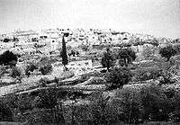
Qalunya, before 1949 | |
 Qalunya | |
| Arabic | قالونيا |
| Name meaning | from the Latin Colonia[1] |
| Also spelled | Qaluniya, Colonia, Kolonia |
| Subdistrict | Jerusalem |
| Coordinates | 31°47′39″N 35°9′27″E / 31.79417°N 35.15750°ECoordinates: 31°47′39″N 35°9′27″E / 31.79417°N 35.15750°E |
| Palestine grid | 165/133 |
| Population | 1,056 (1948) |
| Area | 4,844 dunams |
| Date of depopulation | early April, 1948,[2] |
| Cause(s) of depopulation | Military assault by Yishuv forces |
| Current localities | Mevaseret Zion |
Qalunya (Arabic: قالونيا, also transliterated Qaluniya, Colonia and Kolonia) was a Palestinian Arab village located 6 kilometers (3.7 mi) west of Jerusalem.[3]
Prior to the village's destruction in 1948, with the exception of 166 dunams, Qalunya's land was privately owned: 3,594 dunams were owned by Arabs, while 1,084 dunams were owned by Jews.
Location
Qalunya stood on a mountain slope, facing southwest; Wadi Qalunya passed through its eastern edge. The village lay on the Jerusalem-Jaffa highway, and a dirt path linked it to its neighboring villages.[4] Qalunya was located near the Jewish town of Motza. Motza is now an outlying neighborhood of Jerusalem, and ruins of demolished buildings from Qalunya are present near Motza, covered in vegetation, just off the main highway between Jerusalem and Tel Aviv.
History
Qalunya is identified with the Canaanite town of Mozah (Joshua 18:26), its name was found stamped on pottery handles in Tall al-Nasba. during First and Second Temple periods Mozah was a Jewish village known for its willows[5] that were used at the Temple of Jerusalem, the village was destroyed in the First Jewish–Roman War. After A.D. 71 Vespasian settled 800 Roman soldiers in the town, which became a Roman settlement known as Colonia Amosa or Colonia Emmaus.[4] It has also been suggested that Qalunya was Emmaus.[6]
The word colonia produced the Byzantine name, Koloneia, for the site. The status of the site in the early Islamic period has not been established, but the name was preserved in Crusader times as Qalonie or Qalunia and in Arabic as Qalunya. Mujir al-Din al-Hanbali (d.1522) reported that in 1192 it was a village near Jerusalem.[7]
Ottoman era
In 1596, Qalunya was a village in the Ottoman Empire, nahiya (subdistrict) of Jerusalem under the liwa' (district) of Jerusalem, and it had a population of 110. It paid taxes on a number of crops, including wheat, barley and olives, as well as on goats, beehives and molasses.[8]
In the late nineteenth century, Qalunya was described as a moderate-sized village perched on the slope of a hill, 300 feet (91 m) above a valley. Travelers reported that it had a "modern" restaurant. The villagers tended orange and lemon trees that were planted around a spring in the valley.[9] To the west of the restaurant were ruins, possible of Byzantine origin.[10]
In the 1890s, Jews purchased some of Qalunya's farmlands, and established the village of Motza, the first Jewish settlement outside Jerusalem.[11]
British Mandate era
In the 1922 census of Palestine, conducted by the British Mandate authorities, Qalunieh (Qalonia) had a population 549; 456 Muslims, 88 Jews and 5 Christians,[12] increasing in the 1931 census to 632, 632 Muslims and 10 Christians; in a total of 156 houses.[13]
During the 1929 Palestine riots, several residents of Qalunya attacked an outlying house in Motza belonging to the Maklef family, killing the father, mother, son, two daughters, and their two guests. Three children survived by escaping out a second-story window; one, Mordechai Maklef, later became Chief of Staff of the Israeli Army. The attackers included the lone police officer and armed man in the area, as well as a shepherd employed by the Maklef family. The village was subsequently abandoned by Jews for a year's time.[14]
In 1945, Qalunya had a population of 900 Muslims and 10 Christians, while Motza had a population of 350 Jews.[15] The total land area was 4,844 dunams.[16] A total of 1,224 dunums of land were irrigated or used for plantations, 955 were used for cereals;[17] while 227 dunams were classified as built-up areas.[18]
1948, and after
On 11 April 1948, as part of Operation Nachshon, Hagana forces entered the village and blew up 50 houses.[19] According to Ilan Pappe, Qalunya was one of four villages that were systematically destroyed by Hagana units in this fashion in the immediate wake of the Deir Yassin massacre; the others being, Beit Surik, Biddu and Saris.[19]
References
- ↑ Palmer, 1881, p. 321
- ↑ Morris, 2004, p. xx, village #359. Also gives the cause of depopulation.
- ↑ "Qalunya". Palestine Remembered. Retrieved 2008-03-18.
- 1 2 Khalidi, 1992, p. 309
- ↑ Wheaton, Gerry (2015-02-26). The Role of Jewish Feasts in John's Gospel. Cambridge University Press. p. 140. ISBN 9781316299753.
- ↑ Conder and Kitchener, 1883, SWP III, p. 40
- ↑ Al:Khalidi 1968:181, Cited in Khalidi, 1992, p.309
- ↑ Hütteroth and Abdulfattah, 1977, p. 118. Quoted in Khalidi, 1992, p. 309
- ↑ Conder and Kitchener, 1883, SWP III, p. 17. Quoted in Khalidi, 1992, p.309
- ↑ Conder and Kitchener, 1883, SWP III, p. 132
- ↑ Ochs, Juliana (2011-06-06). Security and Suspicion: An Ethnography of Everyday Life in Israel. University of Pennsylvania Press. p. 31. ISBN 0812205685.
- ↑ Barron, 1923, Table VII, Sub-district of Jerusalem, p. 14
- ↑ Mills, 1932, p. 42
- ↑ Segev, 2013, p. 324
- ↑ Department of Statistics, 1945, p. 25
- ↑ Government of Palestine, Department of Statistics. Village Statistics, April, 1945. Quoted in Hadawi, 1970, p. 58
- ↑ Government of Palestine, Department of Statistics. Village Statistics, April, 1945. Quoted in Hadawi, 1970, p. 103
- ↑ Government of Palestine, Department of Statistics. Village Statistics, April, 1945. Quoted in Hadawi, 1970, p. 153
- 1 2 Pappe, 2006, p. 91.
Bibliography
| Wikimedia Commons has media related to Qalunya. |
- Barron, J. B., ed. (1923). Palestine: Report and General Abstracts of the Census of 1922. Government of Palestine.
- Conder, Claude Reignier; Kitchener, Herbert H. (1883). The Survey of Western Palestine: Memoirs of the Topography, Orography, Hydrography, and Archaeology. 3. London: Committee of the Palestine Exploration Fund.
- Department of Statistics (1945). Village Statistics, April, 1945. Government of Palestine.
- Hadawi, Sami (1970). Village Statistics of 1945: A Classification of Land and Area ownership in Palestine. Palestine Liberation Organization Research Center.
- Hütteroth, Wolf-Dieter; Abdulfattah, Kamal (1977). Historical Geography of Palestine, Transjordan and Southern Syria in the Late 16th Century. Erlanger Geographische Arbeiten, Sonderband 5. Erlangen, Germany: Vorstand der Fränkischen Geographischen Gesellschaft. ISBN 3-920405-41-2.
- Khalidi, Walid (1992). All That Remains: The Palestinian Villages Occupied and Depopulated by Israel in 1948. Washington D.C.: Institute for Palestine Studies. ISBN 0-88728-224-5.
- Mills, E., ed. (1932). Census of Palestine 1931. Population of Villages, Towns and Administrative Areas (PDF). Jerusalem: Government of Palestine.
- Morris, Benny (2004). The Birth of the Palestinian Refugee Problem Revisited. Cambridge University Press. ISBN 978-0-521-00967-6.
- Palmer, E. H. (1881). The Survey of Western Palestine: Arabic and English Name Lists Collected During the Survey by Lieutenants Conder and Kitchener, R. E. Transliterated and Explained by E.H. Palmer. Committee of the Palestine Exploration Fund.
- Pappé, llan (2006). The Ethnic Cleansing of Palestine (Paperback 2008 ed.). Oneworld Publications Limited. ISBN 978-1-85168-555-4.
- Segev, Tom (2013). One Palestine, Complete. Macmillan. ISBN 1466843500.
External links
- Welcome To Qalunya
- Survey of Western Palestine, Map 17: IAA, Wikimedia commons
- Qalunya, from the Khalil Sakakini Cultural Center