Altındağ, Ankara
| Altındağ | |
|---|---|
| District | |
.jpg) | |
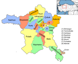 Location of Altındağ, Ankara within Turkey. | |
 Altındağ Location of Altındağ, Ankara within Turkey. | |
| Coordinates: 39°58′N 32°54′E / 39.967°N 32.900°E | |
| Country |
|
| Region | Central Anatolia |
| Province | Ankara |
| Government | |
| • Governor | Hamza Duygun |
| • Mayor | Veysel Tiryaki (AKP) |
| Area[1] | |
| • District | 174.53 km2 (67.39 sq mi) |
| Elevation | 850 m (2,790 ft) |
| Population (2012)[2] | |
| • District | 363,744 |
| • District density | 2,100/km2 (5,400/sq mi) |
| Time zone | EET (UTC+2) |
| • Summer (DST) | EEST (UTC+3) |
| Postal code | 06xxx |
| Area code(s) | 0312 |
| Licence plate | 06 |
| Website | www.altindag.gov.tr |
Altındağ is a metropolitan district of Ankara Province in the Central Anatolia region of Turkey, part of the city of Ankara. According to the 2000 census, the population of the district is 407,101, of which 400,023 live in the urban center of Altındağ.[3][4] The district covers an area of 175 km2 (68 sq mi),[5] and the average elevation is 850 m (2,789 ft).
Geography
Located just outside the city centre, (beyond the district of Ulus as far as the large Altınpark), this hillside has long been home to the workers in the city of Ankara but Altındağ remains one of the poorer quarters of the capital. The hillside is covered with illegally built gecekondu housing, home to low-income families. Among the housing there are some municipal buildings, public housing, state housing for civil servants and lots of small workshops doing car repairs and other light mechanical work.
The ancient Ankara Castle is in Altındağ and there has recently been investment in restoration work. With this architectural heritage, Altındağ is a member of the Norwich-based European Association of Historic Towns and Regions.[6]
History
Altındağ includes parts of the historic city of Ankara, as well as the first National Assembly in which Republic of Turkey was founded is in Ulus.
Altındağ was the location of one of the first gecekondu developments in Turkey, when in the 1950s and 1960s people illegally built small, one-bedroom houses on small plots of land; then in the 1970s and 1980s these plots of land were made legal through amnesty legislation, and eventually sold to developers who replaced these shacks with larger, multi-story apartment buildings.
Prominent neighbourhoods
- Aydınlıkevler - a quiet residential neighbourhood of civil servants and other members of Ankara's middle class; centred on an avenue of schools, banks and shops; contains the SSK teaching hospital, a military officers housing compound, the headquarters of Türk Telekom, Ankara University's faculty of agriculture and Altınpark.
- Hacı Bayram - home to one of the oldest mosques in Ankara, the mosque and tomb of the 14th-century Ankara-born mystic Haci Bayram Veli, famous for prophesying the conquest of Constantinople, and then founding his own Sufi sect. The district has recently been renovated by urban planner Raci Bademli.
Places of interest

- Altınpark - A large park, formerly a golf course, noted for its 10 metre high statue of a loaf of bread at the entrance; contains a fairground, go-karting, ice-skating, large pools for boating and fishing, the Feza Gürsey Science Center, and much more.
- Çamlık - view of the city from the hill
- Ankara Castle (kale) - the hilltop heart of the old city of Ankara, built by the Galatians and the Byzantines, now surrounded with antique shops, coffee houses and bar/restaurants in restored Ottoman-period wooden houses, where traditional Turkish music (fasıl) is played late into the evening. One of Ankara's few historical sites.
- Karapürçek - location of Ankara's annual oil-wrestling tournament.
- Ulucanlar Prison Museum
Notes
- ↑ "Area of regions (including lakes), km²". Regional Statistics Database. Turkish Statistical Institute. 2002. Retrieved 2013-03-05.
- ↑ "Population of province/district centers and towns/villages by districts - 2012". Address Based Population Registration System (ABPRS) Database. Turkish Statistical Institute. Retrieved 2013-02-27.
- ↑ Turkish Statistical Institute. "Census 2000, Key statistics for urban areas of Turkey" (in Turkish). Archived from the original (XLS) on 2007-07-22. Retrieved 2008-03-28.
- ↑ GeoHive. "Statistical information on Turkey's administrative units". Retrieved 2008-03-28.
- ↑ Statoids. "Statistical information on districts of Turkey". Retrieved 2008-04-23.
- ↑ European Association of Historic Towns and Regions. "Historic Towns of Turkey" (DOC). Retrieved 2008-03-28.
References
- Falling Rain Genomics, Inc. "Geographical information on Altındağ, Turkey". Retrieved 2008-03-28.
- Kenthaber Uluslararası İnternet Med.Yay.Ltd.Şti. "General information on Altındağ district of Ankara" (in Turkish). Retrieved 2008-03-28.
External links
| Wikimedia Commons has media related to Altındağ. |
- Altındağ Haberleri (Turkish)
- District governor's official website (Turkish)
- District municipality's official website (Turkish) / (English)
Coordinates: 39°57′49″N 32°54′12″E / 39.96361°N 32.90333°E