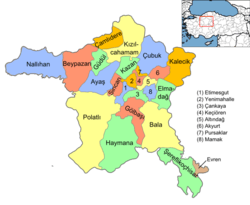
Çankaya, Ankara
| Çankaya | |
|---|---|
| District | |
|
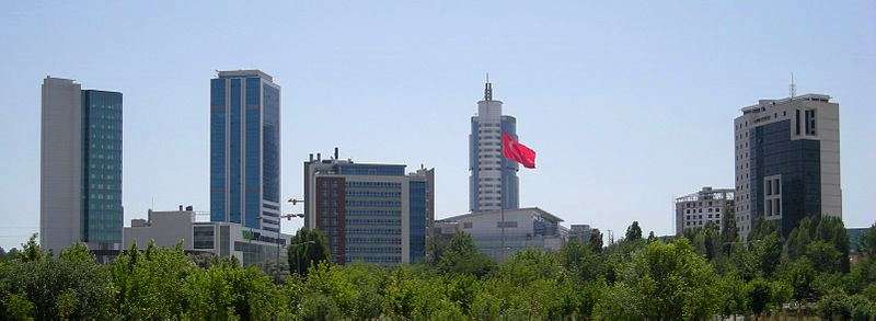
A view of Kızılay Square from the northwest, with the Emek Business Center (1959–1965). | |
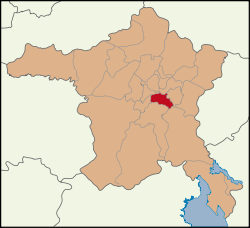 Location of Ankara Çankaya within Turkey. | |
 Çankaya Location of Ankara Çankaya within Turkey. | |
| Coordinates: 39°55′28″N 32°53′08″E / 39.92444°N 32.88556°ECoordinates: 39°55′28″N 32°53′08″E / 39.92444°N 32.88556°E | |
| Country |
|
| Region | Central Anatolia |
| Province | Ankara |
| Government | |
| • Governor | M. Hulusi Arat |
| • Mayor | Alper Taşdelen (CHP) |
| Area[1] | |
| • District | 267.61 km2 (103.32 sq mi) |
| Elevation | 986 m (3,235 ft) |
| Population (2012)[2] | |
| • District | 914.501 |
| • District density | 3.4/km2 (8.9/sq mi) |
| Time zone | EET (UTC+2) |
| • Summer (DST) | EEST (UTC+3) |
| Postal code | 06xxx |
| Area code(s) | 0312 |
| Licence plate | 06 |
| Website | cankayakaymakamligi.gov.tr |

Çankaya is the central metropolitan district of the city of Ankara, the capital of Turkey, and an administrative district of Ankara Province. According to the 2000 census, the population of the urban center is 797,109 (2010 est.) which swells up to 2 million or more people during the day.[3] The district covers an area of 268 km2 (103 sq mi),[4] and the urban center lies at an average elevation of 986 m (3,235 ft).
The President of Turkey resides here, in the "Çankaya Köşkü" presidential compound. The area is also home to many of the capital's embassies, government departments and best-known landmarks. Çankaya is the heart of the city, a fashionable business and cultural centre as well as the centre of government.
History
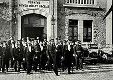
Until the founding of the Republic of Turkey in 1923, Çankaya was a hillside of orchards and gardens to the south of the city, which had grown up in time, surrounding the Ankara Castle (Kale) on the opposite hill. Everything changed in the 1920s when Mustafa Kemal Atatürk came to stay in one of the garden houses. Atatürk selected Ankara as capital of the new republic and in the 1920s and 30s the city quickly grew, especially in the direction of Çankaya. In 1934 the writer Yakup Kadri Karaosmanoğlu described the area as "a wooden bridge, a dirt road, and when you come round the hill you see a hillside, green in gentle contours. That's Çankaya." Çankaya eventually developed into one of the largest central districts of Ankara in later years.
Culture

The early buildings of the republic were in grand Ottoman style, but today Çankaya also contains a number of impressive modern buildings. The district is home to a great number of museums, theatres, cinemas, cultural associations, booksellers, publishers and libraries, including the National Library in a new building. Many of the streets in the district are named after poets, writers and thinkers.
Most of Ankara's best-known high schools and a great number of university buildings are in the district, including the large campuses of METU, Bilkent University and (most of) Hacettepe University. Çankaya University, a private institution owned by businessman Sıtkı Alp, was opened in a number of former school buildings in 1997.
Prominent neighbourhoods
- Anıttepe - a quiet residential neighbourhood in the city center, with parks and sports facilities, next to Atatürk's hilltop mausoleum, the Anıtkabir. The neighbourhood contains a number of public buildings, including the housing units of retired military officers, and an increasing number of shops and offices. The main avenue is Akdeniz Caddesi which means Mediterranean Avenue. The name comes from Atatürk's Turkish War of Independence order Armies, your first destination is the Mediterranean (Ordular... İlk hedefiniz Akdenizdir. İleri! - and the streets are named in the order of Ordular Sokak, Ilk Sokak, Hedef Sokak and Akdeniz Caddesi).
- Ayrancı - A residential district of modest apartment buildings (maximum 5 storeys) on a steep hillside. Until the 1960s this neighbourhood was still full of orchards and gardens.
- Bağcılar - Another new district, a valley of apartment buildings that until the 1970s was made up largely of orchards.
- Bahçelievler - the name means garden-houses, today there are mainly apartment buildings in this green, residential district centred on 7 nci Cadde (7th Avenue), the crowded shopping and strolling avenue of coffee shops and burger restaurants. The district is popular with students, as there are many cafés, bars, fast-food outlets, and easy transport to Hacettepe, Bilkent and Başkent University. Important buildings include the Turkish National Library and the Ankara Ice Palace. The streets in the district mainly have numbers rather than names and one number has unfortunately gone down in history. 15 nci Sokak, number 56, apartment 2 was the location of the code-name 56/2 Bahçelievler massacre in October 1978, in which seven students, members of the Turkish Workers' Party were strangled by right-wing assassins associated with gang-leader Haluk Kırcı.
- Balgat - a large city-centre district of low-price apartment buildings, behind Middle East Technical University. Home to many politicians including one of the ex-premiers Necmettin Erbakan and many of his Saadet party members. Prominent buildings include the large headquarters of the commission that oversees government spending (Sayıştay), the Training and Doctrine Command HQ of the Turkish Armed Forces, the Energy Commission (Energy Market Regulatory Authority) (EPDK) and the headquarters of many political parties including the governing AKP, the centre-right DYP and the nationalist MHP. The Ministry of Foreign Affairs, General Directore of Civil Aviation, Undersecretary of Foreign Trade, Treasury and other key public offices are nearby. Balgat was the subject of a 1950s study by anthropologist Daniel Lerner (The Passing of Traditional Society.)
- Bilkent - One of the youngest neighbourhoods of Ankara, named after the leading private university of the nation, Bilkent University, which is the heart and soul of the neighourhood. Famous with its expensive and luxury housings, as well as significant shopping malls, sports centers and a large scale of leisure activities. Residents are mostly wealthy families and students.
- Cebeci - Named for the Ottoman armoury that was located here, Cebeci is a residential district of narrow streets, popular with students; the faculties of Political Sciences, Law and Education of Ankara University are located here. The Cebeci Asri cemetery was the first modern burial ground in Ankara and is the final resting place of many prominent figures, including assassinated journalists Uğur Mumcu, Bahriye Üçok.
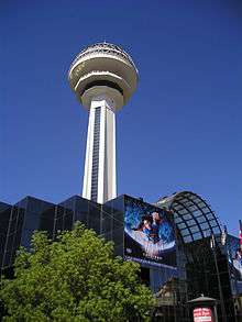
- Çankaya - The main center of the Çankaya district. Traditionally, the residents are among the wealthiest class of the city, mostly politicians, high-ranked bureaucrats, foreign service officers and business people. Residential quarters of the President, Prime Minister and the most prominent ministers, as well as the majority of foreign embassies are found here. Atakule is placed in the heart of Çankaya neighbourhood.
- Çukurambar - A former slum district, now the original cottages of workers (with their little gardens) are being replaced with modern apartment buildings. The Foreign Ministry is located here and there is still open land belonging to the municipal farm/forest park Atatürk Forest Farm and Zoo.
- Emek - an area of two-storey houses, centred on "8. Cadde", a busy avenue of kebab houses.
- Gaziosmanpaşa - one of Ankara's smartest neighbourhoods, luxury housing overlooking the city centre from a hilltop. GOP was formerly known as 14 May after the date of the first secret ballot in Turkey (in 1950) as the new housing built there was popular with MPs of the Demokrat Parti, who won that election. After the party was brought down by a military coup in 1960 the area was named after the Ottoman general Gazi Osman Pasha.
- Harbiye - home of the Army War Academy (Kara Harp Okulu)
- Ilker - a windswept neighbourhood on the eastern side of the hill, one of Ankara's highest points.
- Incesu - the valley of the Incesu stream, which now runs in channels underground.
- Karakusunlar - the odd name has a story to it; when Atatürk arrived with his troops during the Turkish War of Independence, Ankara was under snow and they were unable to find a dry place to camp. Atatürk's order let them camp on the snow (kara kursunlar) has become the name of this district where the scene took place. The village is now a busy district of apartment buildings on a steep slope, behind the Middle East Technical University
- Kavaklıdere - A neighbourhood of tree-lined streets, centred on Ankara's busiest shopping avenue Tunalı Hilmi Caddesi, with its array of cinemas(currently closed down), bookshops, bars, cafés, patisseries, fast-food outlets and Ankara landmarks including the luxury shopping mall Karum, and Kuğulu Park (kuğu means swan in Turkish, although in truth most of the birds in the pond here are ducks.) Until the 1970s this area consisted largely of vineyards and the Kavaklıdere Winery was in this district, where the Sheraton Hotel now stands. The name means stream with poplars in Turkish, but the stream runs underground today and there are few poplars.
- Keklikpınarı - steep hilltop district with chilly weather and a view of the whole city; the point where Atatürk entered Ankara on January 27, 1919, as commemorated by the İlkadım (first steps) Park. Until the 1960s this was a tiny village outside the city.
- Kırkkonaklar - a gecekondu district (now apartment buildings) overlooking the highway, far from the city centre, behind the posh Gazi Osman Paşa district.
- Kızılay - the heart of the city, a mess of bustling streets tightly packed with people swarming in and out of schools and evening classes, cafés, and shops (especially bookshops); with many more rushing to and from work in the many shops and offices in the district. Millions of people come into the district each day for work, school and shopping. The pavements are crowded with hawkers and buskers and are decorated with life-size statues in bronze, sitting, reading, or mining coal. The main avenue has long been the venue for most of Ankara's protest marches and demonstrations, especially by government workers and civil servants.
- Bakanlıklar - a smart area, location of the parliament and many government ministries, (although most are moving to new premises on the Eskişehir road) as well as thousands of shops, including Ankara's market of second-hand books.
- Kumrular Sokak - a tree-lined street of cafés and bookshops.
- Sakarya Caddesi - a street of bars and fish restaurants, Ankara's heart to drink rakı.
- Kızılırmak Sokak - with its cinemas, cafés and evening classes for young people cramming for the university entrance exam.
- Kocatepe - A hill crowned with Ankara's largest mosque. Also known for a high-quality brand of Turkish coffee.
- Küçükesat - a quiet neighbourhood of residential streets, lined with trees, little groceries and kebab sellers and thus popular with retired civil servants (although recently more bars have opened and the main avenue, which is now paraded by Ankara's transvestites.) It is also slightly confusing that the majority of the street-names begin with the letter b.
- Maltepe - an old neighbourhood, once full of workers housing and little workshops, now in decline and best known for its seedy nightclubs, and a large open market for cheap manufactured goods from the former Soviet Union, with commercial copyright infringement of films and software.
- Mebusevleri – a quiet area of little houses and gardens, (although many are now being replaced by apartment buildings), near the Anıtkabir.
- Mustafa Kemal - One of the most luxurious neighborhoods of Ankara, which is along the Eskişehir Road and is near Bilkent, METU and Söğütözü, home to new built Ministry for European Union Affairs, Ministry of Food, Agriculture, and Livestock, Ministry of Science, Industry and Technology, Presidency of the Council of State, etc. Famous with its co-educational private schools, expensive housings, mostly villas and luxury apartments, and its several skyscrapers such as the Building of the Union of Chambers and Commodity Exchanges of Turkey (TOBB) and Tepe Prime Business Residence Avenue as well. Two largest modern shopping malls called Kentpark (Harvey Nichols) and Cepa are located in Mustafa Kemal. Additionally, some international schools, mainly Pakistan Embassy International Study Group and Lycée Franco-Turc de Tevfik Fikret, are in this neighborhood.
- Oran Sitesi - Luxury housing complex with a forest behind, home to many of Turkey's leading politicians. Prominent buildings include the parliament residences, army accommodation, the headquarters of the Turkish Radio and Television Corporation and a number of quality restaurants.
- Öveçler - Residential area, 4üncü Cadde is home to a number of IT companies, IT and language training institutes and also the HQ of the Informatics Associations of Turkey (TBD), founded by academic Aydın Köksal.
- Söğütözü - the area on the Eskişehir road where all the inter-city bus terminals are located. Also the big Bayındır hospital, the Gazi military officer's club, and now a number of new buildings housing government ministries and the headquarters of the opposition party CHP.
- 100. Yıl Sitesi - Used to be a rundown area of low-quality public housing. The blocks were built as housing units for workers, but they are at the borders of the Middle East Technical University, thus very popular with students. Built in 1981, the centenary of Atatürk's birth, hence the name. It is now home to many modern buildings home to middle class as well as foreign workers. It is where the leader of the opposition CHP Kemal Kılıçdaroğlu has his residence.
Climate
The climate in Çankaya is cold and temperate. The winter months are much rainier than the summer months in Çankaya. The Köppen-Geiger climate classification is Dsa. The average annual temperature in Çankaya is 11.5 °C. In a year, the average rainfall is 384 mm.
| Climate data for Çankaya (1950 - 2014) | |||||||||||||
|---|---|---|---|---|---|---|---|---|---|---|---|---|---|
| Month | Jan | Feb | Mar | Apr | May | Jun | Jul | Aug | Sep | Oct | Nov | Dec | Year |
| Average high °C (°F) | 3.8 (38.8) |
6.6 (43.9) |
12.1 (53.8) |
17.4 (63.3) |
22.2 (72) |
26.4 (79.5) |
30.1 (86.2) |
29.6 (85.3) |
25.7 (78.3) |
19.7 (67.5) |
13.2 (55.8) |
6.4 (43.5) |
17.7 (63.9) |
| Daily mean °C (°F) | −0.1 (31.8) |
2.2 (36) |
6.3 (43.3) |
11.1 (52) |
15.4 (59.7) |
19.0 (66.2) |
22.4 (72.3) |
21.8 (71.2) |
17.8 (64) |
12.5 (54.5) |
7.3 (45.1) |
2.6 (36.7) |
11.5 (52.7) |
| Average low °C (°F) | −4.0 (24.8) |
−2.1 (28.2) |
0.5 (32.9) |
4.8 (40.6) |
8.6 (47.5) |
11.6 (52.9) |
14.7 (58.5) |
14.0 (57.2) |
10.0 (50) |
5.3 (41.5) |
1.4 (34.5) |
−1.1 (30) |
5.9 (42.6) |
| Average precipitation mm (inches) | 42.2 (1.661) |
37.0 (1.457) |
38.8 (1.528) |
47.7 (1.878) |
49.7 (1.957) |
35.0 (1.378) |
14.5 (0.571) |
10.5 (0.413) |
19.2 (0.756) |
29.4 (1.157) |
32.6 (1.283) |
45.4 (1.787) |
402 (15.826) |
| Average precipitation days | 12.2 | 11.0 | 10.9 | 11.9 | 12.5 | 8.6 | 3.7 | 2.8 | 3.9 | 6.8 | 8.5 | 11.8 | 104.6 |
| Mean monthly sunshine hours | 77.5 | 98.9 | 161.2 | 189.0 | 260.4 | 306.0 | 350.3 | 328.6 | 276.0 | 198.4 | 132.0 | 71.3 | 2,449.6 |
Places of interest
- The Museum of Anatolian Civilizations
- Anıtkabir the mausoleum of Atatürk
- Ankara Ethnography Museum
- Atakule Tower
- Çankaya Köşkü - the residence of the President of Turkey
- Pembe Köşk - the residence of Turkish President Ismet Inönü from 1925 to 1973
- THF Sport Hall
Notes
- ↑ "Area of regions (including lakes), km²". Regional Statistics Database. Turkish Statistical Institute. 2002. Retrieved 2013-03-05.
- ↑ "Population of province/district centers and towns/villages by districts - 2012". Address Based Population Registration System (ABPRS) Database. Turkish Statistical Institute. Retrieved 2013-02-27.
- ↑ Statistical Institute
- ↑ Statoids. "Statistical information on districts of Turkey". Retrieved 2008-04-23.
References
- Falling Rain Genomics, Inc. "Geographical information on Çankaya, Turkey". Retrieved 2008-03-28.
- Kenthaber.com. "General information on Çankaya district of Ankara" (in Turkish). Retrieved 2008-03-28.
External links
| Wikimedia Commons has media related to Çankaya. |
- Presidency of the Republic of Turkey, official website (Turkish) / (English)
- District governor's official website (Turkish) / (English)
- District municipality's official website (Turkish) / (English)
- The Kavaklıdere resident's association (Turkish)