Kalecik, Ankara
| Kalecik | |
|---|---|
| District | |
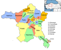 Location of Kalecik, Ankara within Turkey. | |
 Kalecik Location of Kalecik, Ankara within Turkey. | |
| Coordinates: 40°05′50″N 33°24′30″E / 40.09722°N 33.40833°ECoordinates: 40°05′50″N 33°24′30″E / 40.09722°N 33.40833°E | |
| Country |
|
| Region | Central Anatolia |
| Province | Ankara |
| Government | |
| • Governor | İrfan Demiröz |
| • Mayor | Nevzat Şahin (CHP) |
| Area[1] | |
| • District | 1,340.46 km2 (517.55 sq mi) |
| Elevation | 725 m (2,379 ft) |
| Population (2012)[2] | |
| • Urban | 8,730 |
| • District | 13,648 |
| • District density | 10/km2 (26/sq mi) |
| Time zone | EET (UTC+2) |
| • Summer (DST) | EEST (UTC+3) |
| Postal code | 06xxx |
| Area code(s) | 0312 |
| Licence plate | 06 |
| Website | www.kalecik.bel.tr |
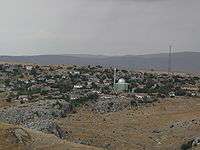
Kalecik is a town and district of Ankara Province in the Central Anatolia region of Turkey. According to 2010 census, population of the district is 14,517 of which 9,450 live in the town of Kalecik.[3][4] The district covers an area of 1,340 km2 (517 sq mi),[5] and the average elevation is 725 m (2,379 ft).
Kalecik stands on a plain with the eastern boundary formed by the River Kızılırmak while there are mountains to the south and the west. This agricultural district is known for its wine; other major crops include sugar beet and grains.
The popular grape variety Kalecik Karası grows successfully near the Kızılırmak and is used to make some of Turkey's best red wine.
History
The area has a history going back to the Hittites and even earlier (4000 BC). In the Ottoman Empire period this was a thriving town recorded by the 17th-century traveler Evliya Çelebi as being a trading city with tanneries, coppersmiths, and weavers.
Education
The vocational school of higher education in Kalecik (Turkish: Kalecik Meslek Yüksekokulu), part of Ankara University, educates in viticulture and winemaking.[6]
Places of interest
- Kalecik Castle, an Ancient Roman ruin on the rock above the town
- Ottoman architecture, including a number of mosques and the seven-arch Develioğlu Köprüsü bridge over the Kızılırmak at 40°02′29″N 33°26′38″E / 40.0414°N 33.4440°E.
Villages in the district
- Afşar
- Akkaynak
- Akkuzulu
- Aktepe
- Akçataş
- Alibeyli
- Altıntaş
- Arkbörk
- Beykavağı
- Buğra
- Dağdemir
- Demirtaş
- Değirmenkaya
- Elmapınar
- Eskiköy
- Eşmedere
- Gökdere
- Gökçeören
- Gölköy
- Gümüşpınar
- Hacıköy
- Hancılı
- Hasayaz
- Karahüyük
- Karalar
- Karatepe
- Kargın
- Keklicek
- Koyunbaba
- Kuyucak
- Kılçak
- Kınık
- Kızılkaya
- Mahmutlar
- Samanlıkköy
- Satılarköy
- Tavşancık
- Tilkiköy
- Uyurca
- Yalımköy
- Yeniçöte
- Yeşilöz
- Yurtyenice
- Yüzbeyli
- Yılanlı
- Çandır
- Çaykaya
- Çiftlikköy
- Şemsettinköy
- Şeyhmahmut
Notes
- ↑ "Area of regions (including lakes), km²". Regional Statistics Database. Turkish Statistical Institute. 2002. Retrieved 2013-03-05.
- ↑ "Population of province/district centers and towns/villages by districts - 2012". Address Based Population Registration System (ABPRS) Database. Turkish Statistical Institute. Retrieved 2013-02-27.
- ↑ Statistical Institute
- ↑ GeoHive. "Statistical information on Turkey's administrative units". Retrieved 2008-03-30.
- ↑ Statoids. "Statistical information on districts of Turkey". Retrieved 2008-05-02.
- ↑ "Şarap Üretim Teknolojisi Programı" (in Turkish). Kalecik Meslek Yüksekokulu. Retrieved 2015-07-28.
References
- Falling Rain Genomics, Inc. "Geographical information on Kalecik, Turkey". Retrieved 2008-03-30.
- Kenthaber.com. "General information on Kalecik, Ankara" (in Turkish). Retrieved 2008-03-31.