Arab, Alabama
| Arab, Alabama | |
|---|---|
| City | |
| Motto: "Proud of our past... embracing the future" | |
 | |
| Coordinates: 34°19′40″N 86°29′55″W / 34.32778°N 86.49861°W | |
| Country | United States |
| State | Alabama |
| Counties | Marshall, Cullman |
| Government | |
| • Type | City Council/Mayor |
| • Mayor | Bob Joslin |
| Area | |
| • Total | 13.1 sq mi (34.0 km2) |
| • Land | 13.0 sq mi (33.6 km2) |
| • Water | 0.1 sq mi (0.3 km2) |
| Elevation | 1,089 ft (332 m) |
| Population (2010) | |
| • Total | 8,050 |
| • Density | 620/sq mi (239.4/km2) |
| Time zone | Central (CST) (UTC-6) |
| • Summer (DST) | CDT (UTC-5) |
| ZIP code | 35016 |
| Area code(s) | 256 , 938 |
| FIPS code | 01-02116 |
| GNIS feature ID | 0113194 |
| Website |
www |
Arab (/ˈeɪ.ræəb/) is a city in Marshall and Cullman counties in the northern part of the U.S. state of Alabama, located 10 miles (16 km) from Guntersville Lake and Guntersville Dam, and is included in the Huntsville-Decatur Combined Statistical Area. As of the 2010 census, the population of the city was 8,050.[1]
Etymology
The name of the town was an unintentional misspelling by the U.S. Postal Service in 1882 of the city's intended name, taken from Arad Thompson, the son of the town founder and first postmaster Stephen Tuttle Thompson. Two other names for the town were sent to the Postal Service for consideration: "Ink" and "Bird". It has frequently been noted on lists of unusual place names.[2]
History
Arab was incorporated in 1892. [3]
Geography
Arab is located on top of Brindlee Mountain at 34°19′40″N 86°29′55″W / 34.32778°N 86.49861°W (34.327863, -86.498613).[4] The city is primarily in southern Marshall County; a small portion extends south into Cullman County.
According to the U.S. Census Bureau, the city has a total area of 13.1 square miles (34.0 km2), of which 14.0 square miles (36.3 km2) is land and 0.12 square miles (0.3 km2), or 1.02%, is water.[1] The town's elevation is 1,124 feet (343 m) above sea level.
Infrastructure
Electricity service in Arab is provided through Arab Electric Cooperative, which buys power through Tennessee Valley Authority. Water service in Arab is provided through Arab Water Works, which gets water from Browns Creek in Guntersville Lake. Natural gas is also provided in Arab through Marshall County Gas District, which is based out of Guntersville.
Government
Arab has a mayor-council form of city government consisting of five council members and a mayor. City elections occur every four years, coinciding with the presidential elections. Council seats are at-large and are not associated with districts. Arab City Schools is the public school district.
Demographics
| Historical population | |||
|---|---|---|---|
| Census | Pop. | %± | |
| 1920 | 264 | — | |
| 1930 | 425 | 61.0% | |
| 1940 | 640 | 50.6% | |
| 1950 | 1,592 | 148.8% | |
| 1960 | 2,989 | 87.8% | |
| 1970 | 4,399 | 47.2% | |
| 1980 | 6,053 | 37.6% | |
| 1990 | 6,321 | 4.4% | |
| 2000 | 7,174 | 13.5% | |
| 2010 | 8,050 | 12.2% | |
| Est. 2015 | 8,295 | [5] | 3.0% |
| U.S. Decennial Census[6] 2013 Estimate[7] | |||
2000 census data
As of the census[8] of 2000, there were 7,174 people, 3,012 households, and 2,075 families residing in the city. The population density was 561.8 inhabitants per square mile (216.9/km2). There were 3,223 housing units at an average density of 252.4 square miles (654 km2) . The racial makeup of the city was 98.29% White, 0.18% Black or African American, 0.49% Native American, 0.39% Asian, 0.17% from other races, and 0.49% from two or more races. 0.66% of the population were Hispanic or Latino of any race.
There were 3,012 households out of which 31.2% had children under the age of 18 living with them, 54.3% were married couples living together, 11.3% had a female householder with no husband present, and 31.1% were non-families. 28.2% of all households were made up of individuals and 13.7% had someone living alone who was 65 years of age or older. The average household size was 2.35 and the average family size was 2.87.
In the city the population was spread out with 23.9% under the age of 18, 7.2% from 18 to 24, 27.6% from 25 to 44, 23.6% from 45 to 64, and 17.8% who were 65 years of age or older. The median age was 40 years. For every 100 females there were 87.2 males. For every 100 females age 18 and over, there were 82.8 males.
The median income for a household in the city was $36,716, and the median income for a family was $45,761. Males had a median income of $32,425 versus $24,265 for females. The per capita income for the city was $20,035. About 8.2% of families and 10.0% of the population were below the poverty line, including 12.5% of those under age 18 and 14.9% of those age 65 or over.
2010 census
As of the census[9] of 2010, there were 8,050 people, 3,359 households, and 2,257 families residing in the city. The population density was 620 inhabitants per square mile (240/km2). There were 3,693 housing units at an average density of 284.1 square miles (736 km2). The racial makeup of the city was 96.6% White, 0.1% Black or African American, 0.6% Native American, 0.7% Asian, 0.7% from other races, and 1.1% from two or more races. 1.7% of the population were Hispanic or Latino of any race.
There were 3,359 households out of which 28.9% had children under the age of 18 living with them, 50.4% were married couples living together, 13.0% had a female householder with no husband present, and 32.8% were non-families. 29.6% of all households were made up of individuals and 14.9% had someone living alone who was 65 years of age or older. The average household size was 2.37 and the average family size was 2.92.
In the city the population was spread out with 23.7% under the age of 18, 8.3% from 18 to 24, 22.0% from 25 to 44, 27.0% from 45 to 64, and 19.1% who were 65 years of age or older. The median age was 42.2 years. For every 100 females there were 88.6 males. For every 100 females age 18 and over, there were 91.4 males.
The median income for a household in the city was $42,435, and the median income for a family was $64,432. Males had a median income of $44,401 versus $40,062 for females. The per capita income for the city was $23,986. About 13.3% of families and 18.1% of the population were below the poverty line, including 27.7% of those under age 18 and 14.8% of those age 65 or over.
Transportation
Notable people
- Vernon Derrick, fiddle and mandolin player[10]
- Fred Nall Hollis, artist[11]
- Jill King, singer/songwriter[12]
- Jack Lively, Major League Baseball pitcher[13]
- Wayne Mills, country music singer[14]
- Monica Potter, actress[15]
References
- 1 2 "Geographic Identifiers: 2010 Demographic Profile Data (G001): Arab city, Alabama". U.S. Census Bureau, American Factfinder. Retrieved June 11, 2014.
- ↑ Parker, Quentin (2010). Welcome to Horneytown, North Carolina, Population: 15: An insider's guide to 201 of the world's weirdest and wildest places. Adams Media.
- ↑ Foscue, Virginia. Place Names in Alabama. University of Alabama Press, 1989.
- ↑ "US Gazetteer files: 2010, 2000, and 1990". United States Census Bureau. 2011-02-12. Retrieved 2011-04-23.
- ↑ "Annual Estimates of the Resident Population for Incorporated Places: April 1, 2010 to July 1, 2015". Retrieved July 2, 2016.
- ↑ "U.S. Decennial Census". Census.gov. Archived from the original on May 11, 2015. Retrieved June 6, 2013.
- ↑ "Annual Estimates of the Resident Population: April 1, 2010 to July 1, 2013". Retrieved June 3, 2014.
- ↑ "American FactFinder". United States Census Bureau. Archived from the original on 2013-09-11. Retrieved 2008-01-31.
- ↑ "American FactFinder". United States Census Bureau. Archived from the original on 2013-09-11. Retrieved 2015-08-03.
- ↑ Maze, Steve. "Vernon Derrick". Arab Today Archives. Retrieved November 30, 2014.
- ↑ Moore, David (March 11, 2009). "Mary Hollis' friends invited to memorial service Sunday". The Arab Tribune. Retrieved November 30, 2014.
- ↑ Cohoon, Rick. "Jill King biography". AllMusic. Retrieved 2008-01-07.
- ↑ "Jack Lively Bio". Baseball Reference. Retrieved 31 January 2013.
- ↑ Stein, Kelsey (December 8, 2013). "Slain country musician Wayne Mills' funeral in Arab will be live-streamed online Sunday afternoon". Alabama Media Group. Retrieved November 30, 2014.
- ↑ Urbancich, John (May 29, 1997). "Ex-Clevelander Soars In "Con Air"". Sun Newspapers, Cleveland. Retrieved November 30, 2014.
External links
Coordinates: 34°19′40″N 86°29′55″W / 34.327863°N 86.498613°W
Municipalities and communities of Cullman County, Alabama, United States | ||
|---|---|---|
| Cities | 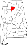 | |
| Towns | ||
| CDPs | ||
| Unincorporated communities | ||
| Footnotes | ‡This populated place also has portions in an adjacent county or counties | |
Municipalities and communities of Marshall County, Alabama, United States | ||
|---|---|---|
| Cities | 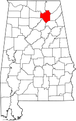 | |
| Towns | ||
| CDPs | ||
| Unincorporated communities | ||
| Ghost town | ||
| Footnotes | ‡This populated place also has portions in an adjacent county or counties | |