Boaz, Alabama
| Boaz, Alabama | ||
|---|---|---|
| City | ||
|
Boaz in 2012 | ||
| ||
| Nickname(s): City of Possibilities | ||
 Location in Marshall County and the state of Alabama | ||
| Coordinates: 34°12′10″N 86°9′37″W / 34.20278°N 86.16028°W | ||
| Country | United States | |
| State | Alabama | |
| Counties | Marshall, Etowah | |
| Government | ||
| • Type | Mayor and Council | |
| • Mayor | Tim Walker | |
| Area | ||
| • Total | 14.61 sq mi (37.85 km2) | |
| • Land | 14.55 sq mi (37.68 km2) | |
| • Water | 0.06 sq mi (0.16 km2) | |
| Elevation | 1,089 ft (332 m) | |
| Population (2010) | ||
| • Total | 9,551 | |
| • Estimate (2014) | 9,689 | |
| • Density | 666/sq mi (257.1/km2) | |
| Time zone | Central (CST) (UTC-6) | |
| • Summer (DST) | CDT (UTC-5) | |
| ZIP code | 35957 and 35956 | |
| Area code(s) | 256 | |
| FIPS code | 01-07912 | |
| GNIS feature ID | 0114631 | |
| Website |
www | |

Boaz is a city in Etowah and Marshall counties in the U.S. state of Alabama. It is part of the Gadsden, Alabama Metropolitan Statistical Area. As of the 2010 census, the population of the city was 9,551.[1] Boaz was known mainly for its outlet shops.
History
First settled in the 1850s, the town of Boaz was officially founded November 11, 1878 by the Sparks Family of Georgia.[2] A post office has been in operation since 1887.[3] The city was named after Boaz, from the Hebrew Bible.[4] It was incorporated in 1897.
Geography
Boaz is located in southeastern Marshall County at 34°12′10″N 86°9′38″W / 34.20278°N 86.16056°W (34.202793, −86.160457),[5] and extends south into Etowah County. It is bordered to the north by Albertville and to the southeast by Sardis City. U.S. Route 431 passes through the east side of the city, leading north 6 miles (10 km) to Albertville and southeast 20 miles (32 km) to Gadsden. Boaz is located on top of Sand Mountain (a plateau), at an elevation of 1,080 feet (330 m) above sea level.
According to the U.S. Census Bureau the city has a total area of 14.6 square miles (37.8 km2), of which 14.6 square miles (37.7 km2) is land and 0.1 square miles (0.2 km2), or 0.43%, is water.[1]
Demographics
| Historical population | |||
|---|---|---|---|
| Census | Pop. | %± | |
| 1900 | 253 | — | |
| 1910 | 1,010 | 299.2% | |
| 1920 | 1,369 | 35.5% | |
| 1930 | 1,691 | 23.5% | |
| 1940 | 1,927 | 14.0% | |
| 1950 | 3,078 | 59.7% | |
| 1960 | 4,654 | 51.2% | |
| 1970 | 5,635 | 21.1% | |
| 1980 | 7,151 | 26.9% | |
| 1990 | 6,928 | −3.1% | |
| 2000 | 7,411 | 7.0% | |
| 2010 | 9,551 | 28.9% | |
| Est. 2015 | 9,688 | [6] | 1.4% |
| U.S. Decennial Census[7] | |||
2010 census
As of the census of 2010, there were 9,551 people, 3,712 households, and 2,479 families residing in the city. The population density was 782.9 people per square mile (302.2/km2). There were 4,036 housing units at an average density of 330.8 per square mile (127.7/km2). The racial makeup of the city was 87.3% White, 1.8% Black or African American, 0.4% Native American, 0.7% Asian, 0.3% Pacific Islander, 7.9% from other races, and 1.6% from two or more races. 14.2% of the population were Hispanic or Latino of any race.
There were 3,712 households out of which 30.7% had children under the age of 18 living with them, 46.7% were married couples living together, 14.3% had a female householder with no husband present, and 33.2% were non-families. 29.6% of all households were made up of individuals and 14.7% had someone living alone who was 65 years of age or older. The average household size was 2.52 and the average family size was 3.11.
In the city the population was spread out with 25.9% under the age of 18, 9.5% from 18 to 24, 26.0% from 25 to 44, 22.2% from 45 to 64, and 16.4% who were 65 years of age or older. The median age was 36 years. For every 100 females there were 90.0 males. For every 100 females age 18 and over, there were 95.4 males.
The median income for a household in the city was $31,172, and the median income for a family was $42,973. Males had a median income of $32,446 versus $27,924 for females. The per capita income for the city was $17,697. About 11.7% of families and 16.0 of the population were below the poverty line, including 24.1% of those under age 18 and 17.1% of those age 65 or over.
2000 census
As of the census of 2000, there were 7,411 people, 3,155 households, and 2,085 families residing in the city. The population density was 607.7 people per square mile (234.5/km2). There were 3,468 housing units at an average density of 284.4 per square mile (109.8/km2). The racial makeup of the city was 93.50% White, 1.31% Black or African American, 0.47% Native American, 0.45% Asian, 0.04% Pacific Islander, 3.01% from other races, and 1.23% from two or more races. 4.98% of the population were Hispanic or Latino of any race.
There were 3,155 households out of which 28.7% had children under the age of 18 living with them, 50.8% were married couples living together, 12.6% had a female householder with no husband present, and 33.9% were non-families. 30.7% of all households were made up of individuals and 16.3% had someone living alone who was 65 years of age or older. The average household size was 2.30 and the average family size was 2.86.
In the city the population was spread out with 23.0% under the age of 18, 8.3% from 18 to 24, 26.2% from 25 to 44, 23.3% from 45 to 64, and 19.2% who were 65 years of age or older. The median age was 39 years. For every 100 females there were 83.8 males. For every 100 females age 18 and over, there were 78.5 males.
The median income for a household in the city was $25,699, and the median income for a family was $34,018. Males had a median income of $29,504 versus $21,750 for females. The per capita income for the city was $15,664. About 13.9% of families and 18.7% of the population were below the poverty line, including 20.7% of those under age 18 and 25.4% of those age 65 or over.
Schools
In May 2004, five schools broke away from the Marshall County School system and formed the Boaz City School System. Boaz is also home to Snead State Community College.
Climate
Climate is characterized by relatively high temperatures and evenly distributed precipitation throughout the year. The Köppen Climate Classification subtype for this climate is "Cfa" (Humid Subtropical Climate).
Notable people
- James Fischer, engineer who developed high-purity silicon technology for Texas Instruments
- Tim Hodge, voice actor and director for Big Idea Entertainment
- Rose Maddox, country music singer-songwriter and fiddle player
- Eddie Priest, former Major League Baseball pitcher
- John Q. Roberts, United States Navy officer who received the Navy Cross posthumously for his actions in combat during World War II
References
- 1 2 "Geographic Identifiers: 2010 Demographic Profile Data (G001): Boaz city, Alabama". American Factfinder. U.S. Census Bureau. Retrieved January 21, 2016.
- ↑ James P. Kaetz. "Boaz". Encyclopedia of Alabama. Retrieved 2016-10-13.
- ↑ "Marshall County". Jim Forte Postal History. Retrieved 30 October 2015.
- ↑ "Tenbroeck in DeKalb County was named for runaway horse". Gadsden Times. Jun 17, 1984. pp. B1. Retrieved 30 October 2015.
- ↑ "US Gazetteer files: 2010, 2000, and 1990". United States Census Bureau. 2011-02-12. Retrieved 2011-04-23.
- ↑ "Annual Estimates of the Resident Population for Incorporated Places: April 1, 2010 to July 1, 2015". Retrieved July 2, 2016.
- ↑ "U.S. Decennial Census". Census.gov. Archived from the original on May 11, 2015. Retrieved June 6, 2013.
External links
Coordinates: 34°12′10″N 86°09′38″W / 34.202793°N 86.160457°W
Municipalities and communities of Etowah County, Alabama, United States | ||
|---|---|---|
| Cities |  | |
| Towns | ||
| CDPs | ||
| Unincorporated communities | ||
| Footnotes | ‡This populated place also has portions in an adjacent county or counties | |
Municipalities and communities of Marshall County, Alabama, United States | ||
|---|---|---|
| Cities | 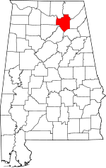 | |
| Towns | ||
| CDPs | ||
| Unincorporated communities | ||
| Ghost town | ||
| Footnotes | ‡This populated place also has portions in an adjacent county or counties | |