Lawrence County, Alabama
| Lawrence County, Alabama | |
|---|---|
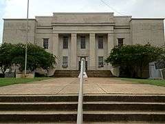 Lawrence County Courthouse in Moulton | |
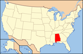
 Location in the U.S. state of Alabama | |
 Alabama's location in the U.S. | |
| Founded | February 6, 1818 |
| Named for | James Lawrence |
| Seat | Moulton |
| Largest city | Moulton |
| Area | |
| • Total | 717 sq mi (1,857 km2) |
| • Land | 691 sq mi (1,790 km2) |
| • Water | 27 sq mi (70 km2), 3.7% |
| Population (est.) | |
| • (2015) | 33,115 |
| • Density | 50/sq mi (19/km²) |
| Congressional district | 4th |
| Time zone | Central: UTC-6/-5 |
| Website |
www |
|
Footnotes:
| |
Lawrence County is a county of the U.S. state of Alabama. As of the 2010 census, the population was 34,339,[1] with the most Native American residents of any county in the state. The county seat is Moulton.[2] The county was named after James Lawrence, a captain in the United States Navy from New Jersey.[3]
Lawrence County is included in the Decatur, AL Metropolitan Statistical Area, which is also included in the Huntsville-Decatur-Albertville, AL Combined Statistical Area.
History
For thousands of years, this area was inhabited by differing cultures of indigenous peoples. People of the Copena culture in the Middle Woodland period (1-500 CE) built complex earthworks as part of their religious and political system. Their burial mound and ceremonial platform mound, the largest in the state, are preserved at Oakville Indian Mounds Park and Museum. The museum includes exhibits on the Cherokee, who inhabited the area at the time of European encounter. Other historic Native American tribes were Choctaw and Creek.
Lawrence County was established by European Americans on February 6, 1818. Under the Indian Removal Act of 1830, the U.S. government forced most tribes to go west to Indian Territory to the west of the Mississippi River, to make way for American settlers and development.
Numerous Cherokee and mixed-race European-Cherokee descendants, sometimes called "Black Dutch", have stayed in the Lawrence County area. The county has the highest number of self-identified Native Americans in the state, including 4,000 members of the Echota Cherokee Tribe of Alabama, which is state recognized.
Geography
According to the U.S. Census Bureau, the county has a total area of 717 square miles (1,860 km2), of which 691 square miles (1,790 km2) is land and 27 square miles (70 km2) (3.7%) is water.[4]
River
Adjacent counties
- Limestone County (northeast)
- Morgan County (east)
- Cullman County (southeast)
- Winston County (south)
- Franklin County (west)
- Colbert County (west)
- Lauderdale County (northwest)
National protected area
Transportation
Major highways
Rail
Demographics
| Historical population | |||
|---|---|---|---|
| Census | Pop. | %± | |
| 1820 | 8,652 | — | |
| 1830 | 14,984 | 73.2% | |
| 1840 | 13,313 | −11.2% | |
| 1850 | 15,258 | 14.6% | |
| 1860 | 13,975 | −8.4% | |
| 1870 | 16,658 | 19.2% | |
| 1880 | 21,392 | 28.4% | |
| 1890 | 20,725 | −3.1% | |
| 1900 | 20,124 | −2.9% | |
| 1910 | 21,984 | 9.2% | |
| 1920 | 24,307 | 10.6% | |
| 1930 | 26,942 | 10.8% | |
| 1940 | 27,880 | 3.5% | |
| 1950 | 27,128 | −2.7% | |
| 1960 | 24,501 | −9.7% | |
| 1970 | 27,281 | 11.3% | |
| 1980 | 30,170 | 10.6% | |
| 1990 | 31,513 | 4.5% | |
| 2000 | 34,803 | 10.4% | |
| 2010 | 34,339 | −1.3% | |
| Est. 2015 | 33,115 | [5] | −3.6% |
| U.S. Decennial Census[6] 1790–1960[7] 1900–1990[8] 1990–2000[9] 2010–2015[1] | |||
As of the census[10] of 2000, there were 34,803 people, 13,538 households, and 10,194 families residing in the county. The population density was 50 people per square mile (19/km2). There were 15,009 housing units at an average density of 22 per square mile (8/km2). The racial makeup of the county was 77.77% White, 13.36% Black or African American, 5.36% Native American, 0.10% Asian, 0.01% Pacific Islander, 0.33% from other races, and 3.08% from two or more races. 1.05% of the population were Hispanic or Latino of any race.
In 2000, the largest ancestry groups in Lawrence County were English 61.2%, African 13.36%, Scots-Irish 4.1% and Welsh 2.0%.
There were 13,538 households out of which 34.70% had children under the age of 18 living with them, 60.50% were married couples living together, 11.20% had a female householder with no husband present, and 24.70% were non-families. 22.60% of all households were made up of individuals and 9.50% had someone living alone who was 65 years of age or older. The average household size was 2.55 and the average family size was 2.99.
In the county the population was spread out with 25.70% under the age of 18, 8.40% from 18 to 24, 30.10% from 25 to 44, 23.70% from 45 to 64, and 12.10% who were 65 years of age or older. The median age was 36 years. For every 100 females there were 96.20 males. For every 100 females age 18 and over, there were 92.40 males.
The median income for a household in the county was $31,549, and the median income for a family was $38,565. Males had a median income of $31,519 versus $20,480 for females. The per capita income for the county was $16,515. About 13.10% of families and 15.30% of the population were below the poverty line, including 16.80% of those under age 18 and 24.50% of those age 65 or over.
2010 census
As of the census[11] of 2010, there were 34,339 people, 13,654 households, and 9,985 families residing in the county. The population density was 50 people per square mile (19/km2). There were 15,229 housing units at an average density of 22 per square mile (8/km2). The racial makeup of the county was 77.6% White, 11.5% Black or African American, 5.7% Native American, 0.1% Asian, 0.0% Pacific Islander, 0.8% from other races, and 4.3% from two or more races. 1.7% of the population were Hispanic or Latino of any race.
There were 13,654 households out of which 29.4% had children under the age of 18 living with them, 55.7% were married couples living together, 12.6% had a female householder with no husband present, and 26.9% were non-families. 24.2% of all households were made up of individuals and 10.2% had someone living alone who was 65 years of age or older. The average household size was 2.50 and the average family size was 2.95.
In the county the population was spread out with 23.2% under the age of 18, 8.4% from 18 to 24, 24.8% from 25 to 44, 29.1% from 45 to 64, and 14.6% who were 65 years of age or older. The median age was 40.6 years. For every 100 females there were 95.7 males. For every 100 females age 18 and over, there were 97.4 males.
The median income for a household in the county was $40,516, and the median income for a family was $48,425. Males had a median income of $45,787 versus $27,341 for females. The per capita income for the county was $19,370. About 10.3% of families and 13.6% of the population were below the poverty line, including 17.3% of those under age 18 and 11.0% of those age 65 or over.
Education
Lawrence County is home to four high schools: East Lawrence High School (4A), Hatton High School (2A), Lawrence County High School (5A), and R.A. Hubbard High School (1A). Lawrence County also has six elementary schools and two middle schools. Other educational facilities include the Lawrence County Center of Technology and the Judy Jester Learning Center.[12]
Former high schools, Hazlewood High School, Speake High School, and Mt. Hope High School were closed in 2009.[13]
Government
| Year | GOP | DNC | Others |
|---|---|---|---|
| 2016 | 73.0% 10,732 | 24.5% 3,611 | 2.5% 268 |
| 2012 | 62.9% 8,855 | 35.9% 5,055 | 1.2% 169 |
| 2008 | 63.2% 9,277 | 35.2% 5,164 | 1.6% 239 |
| 2004 | 55.2% 7,730 | 44.0% 6,155 | 0.8% 116 |
| 2000 | 46.5% 5,671 | 51.7% 6,296 | 1.8% 218 |
Communities
Cities
- Moulton (county seat)
Towns
CDPs
Unincorporated communities
Places of interest
Lawrence County is home to part of the William B. Bankhead National Forest, Oakville Indian Mounds, and Jesse Owens Memorial Park. The Black Warrior Path, which starts in Cullman County, runs through this county and passes the Oakville Indian Mounds. It was used by Native Americans for hundreds of years, and was later used by pioneer settlers.
Events
Every year, Lawrence County hosts numerous events, including the AHSAA Cross Country state championships at the Oakville Indian Mounds, the Lawrence County Basketball Tournament in Moulton, and the Alabama Indian Festival at the Oakville Indian Mounds.
See also
- National Register of Historic Places listings in Lawrence County, Alabama
- Properties on the Alabama Register of Landmarks and Heritage in Lawrence County, Alabama
References
- 1 2 "State & County QuickFacts". United States Census Bureau. Retrieved May 16, 2014.
- ↑ "Find a County". National Association of Counties. Retrieved 2011-06-07.
- ↑ Gannett, Henry (1905). The Origin of Certain Place Names in the United States. U.S. Government Printing Office. p. 182.
- ↑ "2010 Census Gazetteer Files". United States Census Bureau. August 22, 2012. Retrieved August 22, 2015.
- ↑ "County Totals Dataset: Population, Population Change and Estimated Components of Population Change: April 1, 2010 to July 1, 2015". Retrieved July 2, 2016.
- ↑ "U.S. Decennial Census". United States Census Bureau. Retrieved August 22, 2015.
- ↑ "Historical Census Browser". University of Virginia Library. Retrieved August 22, 2015.
- ↑ Forstall, Richard L., ed. (March 24, 1995). "Population of Counties by Decennial Census: 1900 to 1990". United States Census Bureau. Retrieved August 22, 2015.
- ↑ "Census 2000 PHC-T-4. Ranking Tables for Counties: 1990 and 2000" (PDF). United States Census Bureau. April 2, 2001. Retrieved August 22, 2015.
- ↑ "American FactFinder". United States Census Bureau. Retrieved 2011-05-14.
- ↑ "American FactFinder". United States Census Bureau. Retrieved 2015-07-30.
- ↑ http://www.lawrenceal.org/
- ↑ http://www.cullmantimes.com/localsports/x1048558949/Ex-Hazlewood-football-stars-Langham-Goode-have-mixed-emotions-about-school-s-closing
- ↑ "Dave Leip's Atlas of U.S. Presidential Elections". Retrieved November 21, 2016.
External links
- Lawrence County Chamber of Commerce
- East Lawrence High School
- Lawrence County School System
- Lawrence County Sheriff's Office
 |
Lauderdale County | Limestone County | | |
| Franklin County and Colbert County | |
Morgan County | ||
| ||||
| | ||||
| Winston County | Cullman County |
Municipalities and communities of Lawrence County, Alabama, United States | ||
|---|---|---|
| City | | |
| Towns | ||
| CDP | ||
| Unincorporated communities | ||
Coordinates: 34°31′17″N 87°18′37″W / 34.52139°N 87.31028°W