Morgan County, Alabama
| Morgan County, Alabama | |
|---|---|
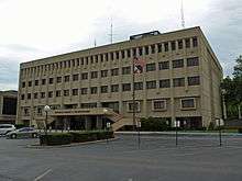 The Morgan County Courthouse in Decatur | |
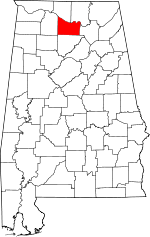 Location in the U.S. state of Alabama | |
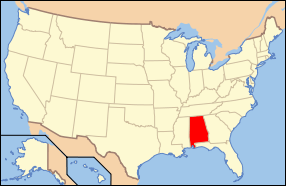 Alabama's location in the U.S. | |
| Founded | February 6[1], 1818[1] |
| Named for | Daniel Morgan |
| Seat | Decatur |
| Largest city | Decatur |
| Area | |
| • Total | 599 sq mi (1,551 km2) |
| • Land | 579 sq mi (1,500 km2) |
| • Water | 20 sq mi (52 km2), 3.3% |
| Population (est.) | |
| • (2015) | 119,565 |
| • Density | 207/sq mi (80/km²) |
| Congressional district | 5th |
| Time zone | Central: UTC-6/-5 |
| Website |
www |
|
Footnotes:
| |
Morgan County is a county in the north central part of the U.S. state of Alabama. As of the 2010 census the population was 119,490.[2] The county seat is Decatur.[3] The county was created by the Alabama Territorial legislature on February 6, 1818 from land acquired from the Cherokee Indians in the Treaty of Turkeytown, and was originally called Cotaco County.[1] On June 14, 1821 it was renamed in honor of American Revolutionary War General Daniel Morgan of Virginia.[4] It is a prohibition or dry county, though the city of Decatur is wet.
Morgan County is included in the Decatur, AL Metropolitan Statistical Area, which is also included in the Huntsville-Decatur-Albertville, AL Combined Statistical Area. It is a part of the North, Northwest, and North-Central regions of Alabama.
Geography
According to the U.S. Census Bureau, the county has a total area of 599 square miles (1,550 km2), of which 579 square miles (1,500 km2) is land and 20 square miles (52 km2) (3.3%) is water.[5]
River
Adjacent counties
- Madison County (northeast)
- Marshall County (east)
- Cullman County (south)
- Lawrence County (west)
- Limestone County (northwest)
National protected area
Demographics
| Historical population | |||
|---|---|---|---|
| Census | Pop. | %± | |
| 1820 | 5,263 | — | |
| 1830 | 9,062 | 72.2% | |
| 1840 | 9,841 | 8.6% | |
| 1850 | 10,125 | 2.9% | |
| 1860 | 11,335 | 12.0% | |
| 1870 | 12,187 | 7.5% | |
| 1880 | 16,428 | 34.8% | |
| 1890 | 24,089 | 46.6% | |
| 1900 | 28,820 | 19.6% | |
| 1910 | 33,781 | 17.2% | |
| 1920 | 40,196 | 19.0% | |
| 1930 | 46,176 | 14.9% | |
| 1940 | 48,148 | 4.3% | |
| 1950 | 52,924 | 9.9% | |
| 1960 | 60,454 | 14.2% | |
| 1970 | 77,306 | 27.9% | |
| 1980 | 90,231 | 16.7% | |
| 1990 | 100,043 | 10.9% | |
| 2000 | 111,064 | 11.0% | |
| 2010 | 119,490 | 7.6% | |
| Est. 2015 | 119,565 | [6] | 0.1% |
| U.S. Decennial Census[7] 1790–1960[8] 1900–1990[9] 1990–2000[10] 2010–2015[2] | |||
As of the census[11] of 2000, there were 111,064 people, 43,602 households, and 31,437 families residing in the county. The population density was 191 people per square mile (74/km2). There were 47,388 housing units at an average density of 81 per square mile (31/km2). The racial makeup of the county was 85.07% White, 11.24% Black or African American, 0.67% Native American, 0.45% Asian, 0.07% Pacific Islander, 1.25% from other races, and 1.25% from two or more races. 3.28% of the population were Hispanic or Latino of any race.
According to the census[12] of 2000, the largest ancestry groups in Morgan County were English 60.1%, Scots-Irish 12.71%, and African 11.24%
There were 43,602 households out of which 33.50% had children under the age of 18 living with them, 57.40% were married couples living together, 11.20% had a female householder with no husband present, and 27.90% were non-families. 24.80% of all households were made up of individuals and 9.40% had someone living alone who was 65 years of age or older. The average household size was 2.51 and the average family size was 2.99.
In the county the population was spread out with 25.30% under the age of 18, 8.40% from 18 to 24, 30.10% from 25 to 44, 23.80% from 45 to 64, and 12.30% who were 65 years of age or older. The median age was 37 years. For every 100 females there were 96.20 males. For every 100 females age 18 and over, there were 93.50 males.
The median income for a household in the county was $37,803, and the median income for a family was $45,827. Males had a median income of $35,759 versus $21,885 for females. The per capita income for the county was $19,223. About 9.70% of families and 12.30% of the population were below the poverty line, including 15.90% of those under age 18 and 12.80% of those age 65 or over.
2010 census
As of the census[13] of 2010, there were 119,490 people, 47,030 households, and 33,135 families residing in the county. The population density was 206.4 people per square mile (79.7/km2). There were 51,193 housing units at an average density of 88 per square mile (34/km2). The racial makeup of the county was 79.8% White, 11.9% Black or African American, 0.9% Native American, 0.6% Asian, 0.1% Pacific Islander, 4.8% from other races, and 2.0% from two or more races. 7.7% of the population were Hispanic or Latino of any race.
There were 47,030 households out of which 30.0% had children under the age of 18 living with them, 52.9% were married couples living together, 12.9% had a female householder with no husband present, and 29.5% were non-families. 25.9% of all households were made up of individuals and 9.8% had someone living alone who was 65 years of age or older. The average household size was 2.50 and the average family size was 2.99.
In the county the population was spread out with 24.0% under the age of 18, 8.4% from 18 to 24, 26.1% from 25 to 44, 27.5% from 45 to 64, and 14.1% who were 65 years of age or older. The median age was 39 years. For every 100 females there were 97.2 males. For every 100 females age 18 and over, there were 100.4 males.
The median income for a household in the county was $44,349, and the median income for a family was $54,653. Males had a median income of $43,455 versus $29,270 for females. The per capita income for the county was $23,090. About 10.9% of families and 15.0% of the population were below the poverty line, including 21.9% of those under age 18 and 12.0% of those age 65 or over.
Government
| Year | GOP | DNC | Others |
|---|---|---|---|
| 2016 | 74.0% 37,392 | 22.2% 11,216 | 3.8% 1,901 |
| 2012 | 71.8% 35,309 | 27.2% 13,401 | 1.0% 488 |
| 2008 | 71.3% 36,014 | 27.5% 13,895 | 1.2% 633 |
| 2004 | 69.1% 32,477 | 30.1% 14,131 | 0.8% 399 |
| 2000 | 60.4% 25,774 | 37.6% 16,060 | 2.0% 847 |
Transportation
Major highways
Rail
Communities
Cities
- Decatur (county seat; part of Decatur is in Limestone County)
- Hartselle
Towns
Unincorporated communities
Ghost town
See also
- National Register of Historic Places listings in Morgan County, Alabama
- Properties on the Alabama Register of Landmarks and Heritage in Morgan County, Alabama
References
- 1 2 3 Acts Passed at the First Session of the First General Assembly, of the Alabama Territory: In the Forty Second Year of American Independence (1818). St. Stephens, Alabama, printed by Thomas Eastin. Reprinted T.L. Cole, Washington, D.C., July 1912. Pages 8-12. "An Act to establish the counties of Cotaco, Lawrence and Franklin...Approved-6th February, 1818."
- 1 2 "State & County QuickFacts". United States Census Bureau. Retrieved May 16, 2014.
- ↑ "Find a County". National Association of Counties. Retrieved 2011-06-07.
- ↑ Acts Passed at the Called Session of the General Assembly of the State of Alabama Begun and Held in the Town of Cahawba, on the First Monday in June, One Thousand Eight Hundred and Twenty One (1821). Cahawba, Alabama: Printed by Allen & Brickell, State Printers. Reprint by Statute Law Book Co., Washington, D.C. Nov. 1913. Page 40. "An Act to change the name of Ococoposa, and for other purposes...Approved, June 14, 1821."
- ↑ "2010 Census Gazetteer Files". United States Census Bureau. August 22, 2012. Retrieved August 22, 2015.
- ↑ "County Totals Dataset: Population, Population Change and Estimated Components of Population Change: April 1, 2010 to July 1, 2015". Retrieved July 2, 2016.
- ↑ "U.S. Decennial Census". United States Census Bureau. Retrieved August 22, 2015.
- ↑ "Historical Census Browser". University of Virginia Library. Retrieved August 22, 2015.
- ↑ Forstall, Richard L., ed. (March 24, 1995). "Population of Counties by Decennial Census: 1900 to 1990". United States Census Bureau. Retrieved August 22, 2015.
- ↑ "Census 2000 PHC-T-4. Ranking Tables for Counties: 1990 and 2000" (PDF). United States Census Bureau. April 2, 2001. Retrieved August 22, 2015.
- ↑ "American FactFinder". United States Census Bureau. Retrieved 2011-05-14.
- ↑ "American FactFinder". United States Census Bureau. Retrieved 2008-01-31.
- ↑ "American FactFinder". United States Census Bureau. Retrieved 2015-08-05.
- ↑ "Dave Leip's Atlas of U.S. Presidential Elections". Retrieved November 21, 2016.
External links
| Wikimedia Commons has media related to Morgan County, Alabama. |
 |
Limestone County | Madison County | | |
| Lawrence County | |
Marshall County | ||
| ||||
| | ||||
| Cullman County |
Municipalities and communities of Morgan County, Alabama, United States | ||
|---|---|---|
| Cities | | |
| Towns | ||
| Unincorporated communities | ||
| Ghost town | ||
| Footnotes | ‡This populated place also has portions in an adjacent county or counties | |
Coordinates: 34°27′06″N 86°51′26″W / 34.45167°N 86.85722°W