Araras
| Araras | |||
|---|---|---|---|
| Municipality | |||
| City of Araras | |||
|
Fountain in Barão de Araras Square with the 100th Anniversary City Monument at the back | |||
| |||
| Nickname(s): Cidade das árvores | |||
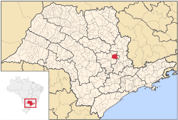
 Location of Araras | |||
 Araras Location in Brazil | |||
| Coordinates: 22°21′26″S 47°23′04″W / 22.35722°S 47.38444°WCoordinates: 22°21′26″S 47°23′04″W / 22.35722°S 47.38444°W | |||
| Country |
| ||
| Region | Southeast | ||
| State | São Paulo | ||
| Mesoregion | Piracicaba | ||
| Microregion | Limeira | ||
| Founded | August 15, 1862 | ||
| Government | |||
| • Mayor | Nelson Dimas Brambilla (PT) | ||
| Area[1] | |||
| • Total | 644.831 km2 (248.971 sq mi) | ||
| Elevation | 629 m (2,064 ft) | ||
| Population (2010)[1] | |||
| • Total | 118,843 | ||
| • Density | 180/km2 (480/sq mi) | ||
| Demonym(s) | Ararense | ||
| Time zone | Brasilia Official Time (UTC-3) | ||
| • Summer (DST) | Brazilian Daylight Saving Time (UTC-2) | ||
| Postal Code | 13600-000 | ||
| Area code(s) | (+55) 19 | ||
| Website |
www | ||
Araras (Portuguese pronunciation: [ɐˈɾaɾɐs]) is a municipality located in the interior of State of São Paulo, Brazil. The population is 118,898 as of the 2010 IBGE Census.[1]
Etymology
Araras means macaws.
Sports
União São João Esporte Clube, founded in 1981, is the most successful football club of the city.[2]
References
This article is issued from Wikipedia - version of the 7/23/2016. The text is available under the Creative Commons Attribution/Share Alike but additional terms may apply for the media files.

