Ribeirão Pires
| Ribeirão Pires | |||
|---|---|---|---|
| Municipality | |||
|
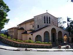
First church of Ribeirão Pires | |||
| |||
 Location in São Paulo state | |||
 Ribeirão Pires Location in Brazil | |||
| Coordinates: 23°42′55″S 46°25′10″W / 23.71528°S 46.41944°WCoordinates: 23°42′55″S 46°25′10″W / 23.71528°S 46.41944°W | |||
| Country |
| ||
| Region | Southeast Region | ||
| State | São Paulo | ||
| Government | |||
| • Mayor | Saulo Mariz Benevides (PMDB) | ||
| Area[1] | |||
| • Total | 99.1 km2 (38.3 sq mi) | ||
| Elevation | 800 m (2,600 ft) | ||
| Population (2015)[1] | |||
| • Total | 120,396 | ||
| • Density | 1,200/km2 (3,100/sq mi) | ||
| Time zone | BRT/BRST (UTC-3/-2) | ||
| Website |
www | ||

Ribeirão Pires is a city in the Metropolitan Region of São Paulo (state), Brazil. It is part of the "ABC Region." The population is 120,396 (2015 est.) in an area of 99.1 km².[1] The elevation is 763 m.
Its neighboring cities are Ferraz de Vasconcelos to the north, Suzano to the northeast and east, Rio Grande da Serra to the southeast and south, Santo Andre southwest and Mauá northwest. The city is served by trains from line 10 of CPTM. It became its own municipality in 1953, following its emancipation from Santo André.
Famous people from Ribeirão Pires
References
This article is issued from Wikipedia - version of the 10/22/2016. The text is available under the Creative Commons Attribution/Share Alike but additional terms may apply for the media files.