Mogi Guaçu
This article is about the city. For the river, see Mojiguaçu River.
| Mogi Guaçu | |||
|---|---|---|---|
| Municipality | |||
| |||
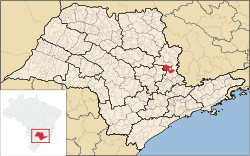 Location in São Paulo state | |||
 Mogi Guaçu Location in Brazil | |||
| Coordinates: 22°22′19″S 46°56′31″W / 22.37194°S 46.94194°WCoordinates: 22°22′19″S 46°56′31″W / 22.37194°S 46.94194°W | |||
| Country |
| ||
| Region | Southeast Region | ||
| State | São Paulo | ||
| Government | |||
| • Mayor | Walter Caveanha (2013–2017) | ||
| Area | |||
| • Total | 813 km2 (314 sq mi) | ||
| Elevation | 591 m (1,939 ft) | ||
| Population (2015) | |||
| • Total | 147,233 | ||
| • Density | 180/km2 (470/sq mi) | ||
| Time zone | BRT/BRST (UTC-3/-2) | ||
| Postal code | 13840-000 | ||
| Area code | +55 19 | ||
| Website |
www | ||

Mogi Guaçu is a municipality in the state of São Paulo in Brazil. The population is 147,233 (2015 est.) in an area of 813 km².[1] The city is at an average elevation (above sea level) of 591 m. Mogi Guaçu is a place name that probably originates from the Tupi language. It means "large river of snakes".[2] The city was founded on April 9, 1877.
The municipality contains the 469 hectares (1,160 acres) Mogi-Guaçu Biological Reserve, a fully protected conservation area created in 1942.[3]
Sister Cities
References
- ↑ Instituto Brasileiro de Geografia e Estatística
- ↑ NAVARRO, E. A. Dicionário de tupi antigo: a língua indígena clássica do Brasil. São Paulo. Global. 2013. p. 588.
- ↑ Núcleo de Pesquisa Reserva Biológica de Mogi Guaçu (in Portuguese), Secretaria do Meio Ambiente do Estado de São Paulo, retrieved 2016-04-28
This article is issued from Wikipedia - version of the 6/24/2016. The text is available under the Creative Commons Attribution/Share Alike but additional terms may apply for the media files.